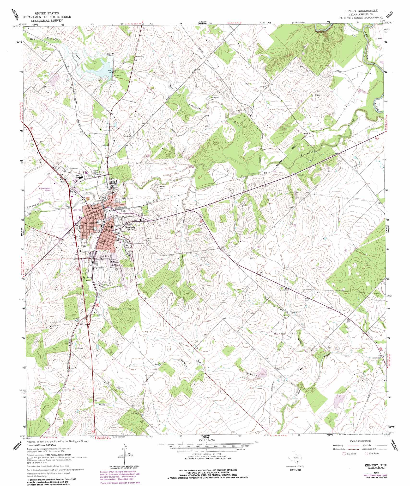
Kenedy Topo Map Texas
To zoom in, hover over the map of Kenedy
USGS Topo Quad 28097g7 - 1:24,000 scale
| Topo Map Name: | Kenedy |
| USGS Topo Quad ID: | 28097g7 |
| Print Size: | ca. 21 1/4" wide x 27" high |
| Southeast Coordinates: | 28.75° N latitude / 97.75° W longitude |
| Map Center Coordinates: | 28.8125° N latitude / 97.8125° W longitude |
| U.S. State: | TX |
| Filename: | o28097g7.jpg |
| Download Map JPG Image: | Kenedy topo map 1:24,000 scale |
| Map Type: | Topographic |
| Topo Series: | 7.5´ |
| Map Scale: | 1:24,000 |
| Source of Map Images: | United States Geological Survey (USGS) |
| Alternate Map Versions: |
Kenedy TX 1961, updated 1963 Download PDF Buy paper map Kenedy TX 1961, updated 1963 Download PDF Buy paper map Kenedy TX 1961, updated 1987 Download PDF Buy paper map Kenedy TX 2010 Download PDF Buy paper map Kenedy TX 2013 Download PDF Buy paper map Kenedy TX 2016 Download PDF Buy paper map |
1:24,000 Topo Quads surrounding Kenedy
Poth |
Kosciusko |
Ecleto |
Garfield |
New Davy |
Falls City |
Karnes City |
Helena |
Runge |
Yorktown West |
Coy City |
Lenz |
Kenedy |
Choate |
Runge Se |
Pawnee |
Monteola |
Tulsita |
Berclair Nw |
Charco |
Ray Point |
Mineral |
Tuleta |
Lazy F Ranch |
Berclair |
> Back to 28097e1 at 1:100,000 scale
> Back to 28096a1 at 1:250,000 scale
> Back to U.S. Topo Maps home
Kenedy topo map: Gazetteer
Kenedy: Airports
Karnes County Airport elevation 89m 291′Kenedy: Dams
Dam Number 11 elevation 89m 291′Soil Conservation Service Site 11 Dam elevation 92m 301′
Soil Conservation Service Site 2 Dam elevation 86m 282′
Soil Conservation Service Site 3 Dam elevation 80m 262′
Kenedy: Oilfields
Hondo Creek Oil Field elevation 86m 282′Kenedy: Parks
Ball Park elevation 86m 282′Kenedy: Populated Places
Kenedy elevation 81m 265′Kenedy: Reservoirs
Soil Conservation Service Site 11 Reservoir elevation 92m 301′Soil Conservation Service Site 2 Reservoir elevation 86m 282′
Soil Conservation Service Site 3 Reservoir elevation 80m 262′
Kenedy: Streams
Dry Escondido Creek elevation 70m 229′Nichols Creek elevation 76m 249′
Panther Creek elevation 82m 269′
Kenedy: Valleys
Carr Hollow elevation 73m 239′Cow Hollow elevation 75m 246′
Possum Hollow elevation 98m 321′
Rock Hollow elevation 75m 246′
Kenedy digital topo map on disk
Buy this Kenedy topo map showing relief, roads, GPS coordinates and other geographical features, as a high-resolution digital map file on DVD: