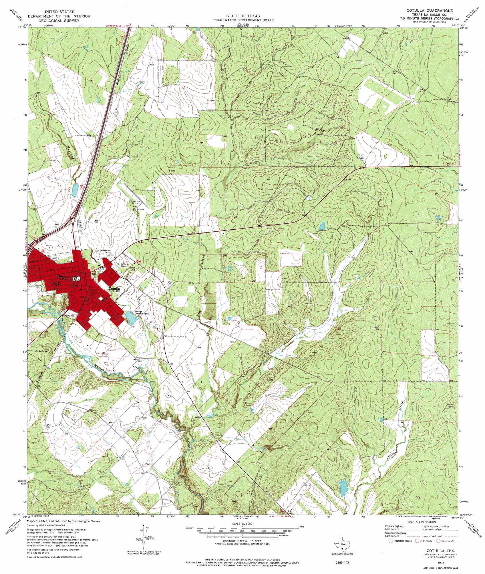
Cotulla Topo Map Texas
To zoom in, hover over the map of Cotulla
USGS Topo Quad 28099d2 - 1:24,000 scale
| Topo Map Name: | Cotulla |
| USGS Topo Quad ID: | 28099d2 |
| Print Size: | ca. 21 1/4" wide x 27" high |
| Southeast Coordinates: | 28.375° N latitude / 99.125° W longitude |
| Map Center Coordinates: | 28.4375° N latitude / 99.1875° W longitude |
| U.S. State: | TX |
| Filename: | o28099d2.jpg |
| Download Map JPG Image: | Cotulla topo map 1:24,000 scale |
| Map Type: | Topographic |
| Topo Series: | 7.5´ |
| Map Scale: | 1:24,000 |
| Source of Map Images: | United States Geological Survey (USGS) |
| Alternate Map Versions: |
Cotulla TX 1974, updated 1977 Download PDF Buy paper map Cotulla TX 2010 Download PDF Buy paper map Cotulla TX 2013 Download PDF Buy paper map Cotulla TX 2016 Download PDF Buy paper map |
1:24,000 Topo Quads surrounding Cotulla
Snake Creek |
Woodward Ne |
Dilley |
Dilley Ne |
Las Flores |
Las Vegas |
Woodward |
Millett |
Burns Ranch |
Cayman Lake |
Flying W Ranch |
Harris Lake |
Cotulla |
Los Angeles |
Dull |
Blocker Tank |
Artesia Wells |
Holland Dam |
Charco Marrano Creek |
The White Kitchen |
Mesteno Creek North |
Atlee |
Caiman Creek Nw |
Caiman Creek Ne |
Piedra Creek Nw |
> Back to 28099a1 at 1:100,000 scale
> Back to 28098a1 at 1:250,000 scale
> Back to U.S. Topo Maps home
Cotulla topo map: Gazetteer
Cotulla: Airports
Cotulla-La Salle County Airport elevation 140m 459′Cotulla: Dams
Allerkamp Reservoir Dam elevation 113m 370′Burkett Dam elevation 120m 393′
Cohenour Reservoir Dam elevation 114m 374′
Macomber Reservoir Dam elevation 120m 393′
Cotulla: Parks
Alexander Park elevation 131m 429′Cotulla: Populated Places
Cotulla elevation 130m 426′Zamora Acres Colonia elevation 125m 410′
Cotulla: Reservoirs
Allerkamp Reservoir elevation 113m 370′Burkett Lake elevation 120m 393′
Cohenour Reservoir elevation 114m 374′
Macomber Reservoir elevation 120m 393′
Cotulla: Streams
Elm Creek elevation 112m 367′Mustang Creek elevation 113m 370′
Cotulla digital topo map on disk
Buy this Cotulla topo map showing relief, roads, GPS coordinates and other geographical features, as a high-resolution digital map file on DVD: