Batesville Nw Topo Map Texas
To zoom in, hover over the map of Batesville Nw
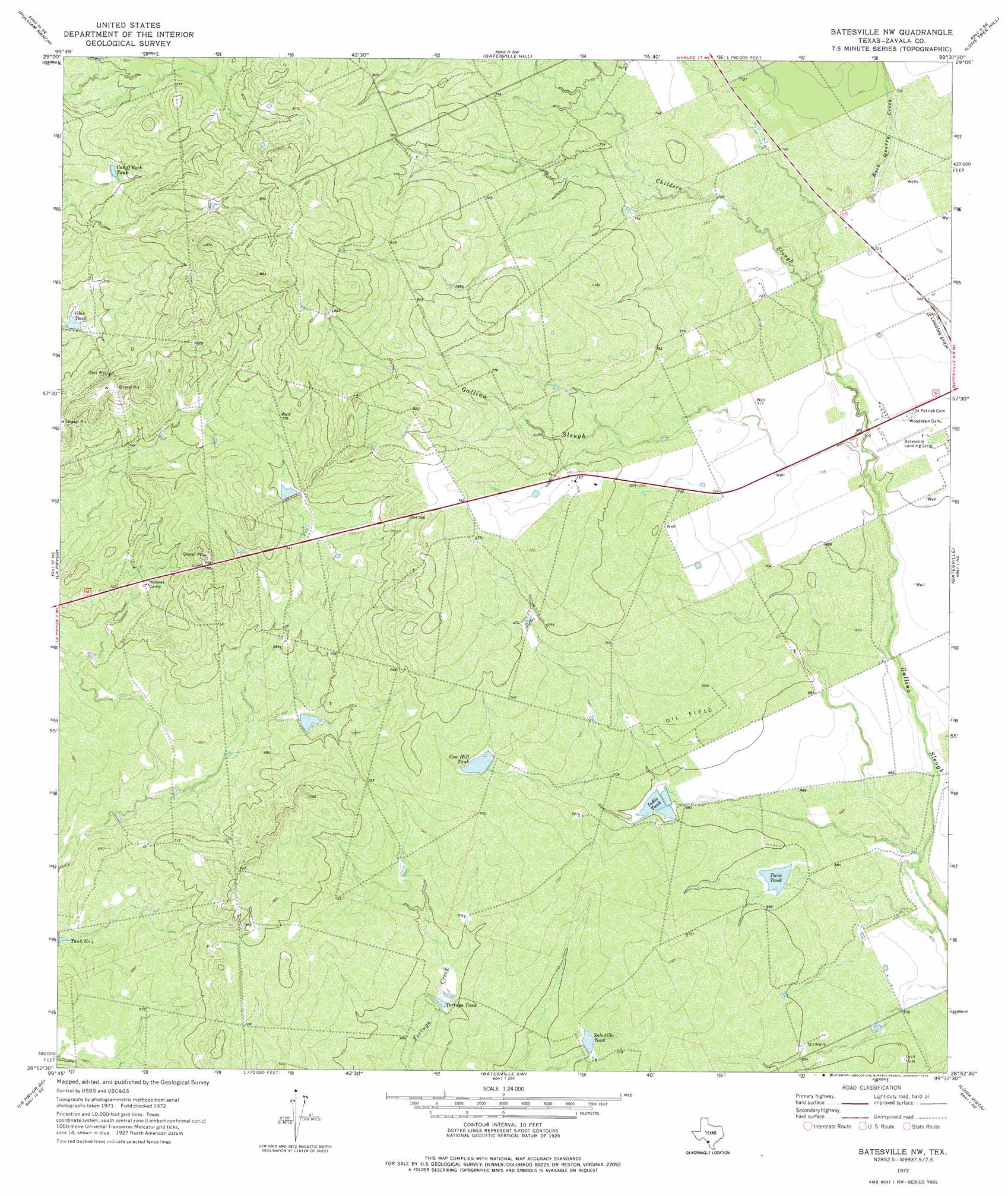
USGS Topo Quad 28099h6 - 1:24,000 scale
| Topo Map Name: | Batesville Nw |
| USGS Topo Quad ID: | 28099h6 |
| Print Size: | ca. 21 1/4" wide x 27" high |
| Southeast Coordinates: | 28.875° N latitude / 99.625° W longitude |
| Map Center Coordinates: | 28.9375° N latitude / 99.6875° W longitude |
| U.S. State: | TX |
| Filename: | o28099h6.jpg |
| Download Map JPG Image: | Batesville Nw topo map 1:24,000 scale |
| Map Type: | Topographic |
| Topo Series: | 7.5´ |
| Map Scale: | 1:24,000 |
| Source of Map Images: | United States Geological Survey (USGS) |
| Alternate Map Versions: |
Batesville NW TX 1972, updated 1975 Download PDF Buy paper map Batesville NW TX 2010 Download PDF Buy paper map Batesville NW TX 2013 Download PDF Buy paper map Batesville NW TX 2016 Download PDF Buy paper map |
1:24,000 Topo Quads surrounding Batesville Nw
Hacienda |
Uvalde |
Garner Field |
Garner Field Ne |
Irishman Hill |
Sand Mountain |
Pulliam Ranch |
Batesville Hill |
Lone Tree Hill |
Gross Tank |
La Pryor Nw |
La Pryor |
Batesville Nw |
Batesville |
Johnnie Little Hill |
Beef Hollow Creek |
La Pryor Se |
Batesville Sw |
Loma Vista |
West Ranch |
Carrizo Springs Nw |
Crystal City |
Woodard Lake |
Sugar Creek |
Snake Creek |
> Back to 28099e1 at 1:100,000 scale
> Back to 28098a1 at 1:250,000 scale
> Back to U.S. Topo Maps home
Batesville Nw topo map: Gazetteer
Batesville Nw: Dams
Cow Hill Tank Dam elevation 222m 728′Indio Dam elevation 216m 708′
Kiefer Lake Dam elevation 227m 744′
Twin Tank Dam elevation 211m 692′
Batesville Nw: Reservoirs
Cow Hill Tank elevation 220m 721′Cutoff Rock Tank elevation 229m 751′
Indio Tank elevation 211m 692′
Kiefer Lake elevation 227m 744′
Obis Tank elevation 226m 741′
Saladillo Tank elevation 214m 702′
Tortuga Tank elevation 210m 688′
Twin Tank elevation 211m 692′
Batesville Nw: Streams
Childers Slough elevation 217m 711′Gallina Creek elevation 212m 695′
Rock Quarry Creek elevation 219m 718′
Batesville Nw: Wells
Obis Well elevation 247m 810′Batesville Nw digital topo map on disk
Buy this Batesville Nw topo map showing relief, roads, GPS coordinates and other geographical features, as a high-resolution digital map file on DVD: