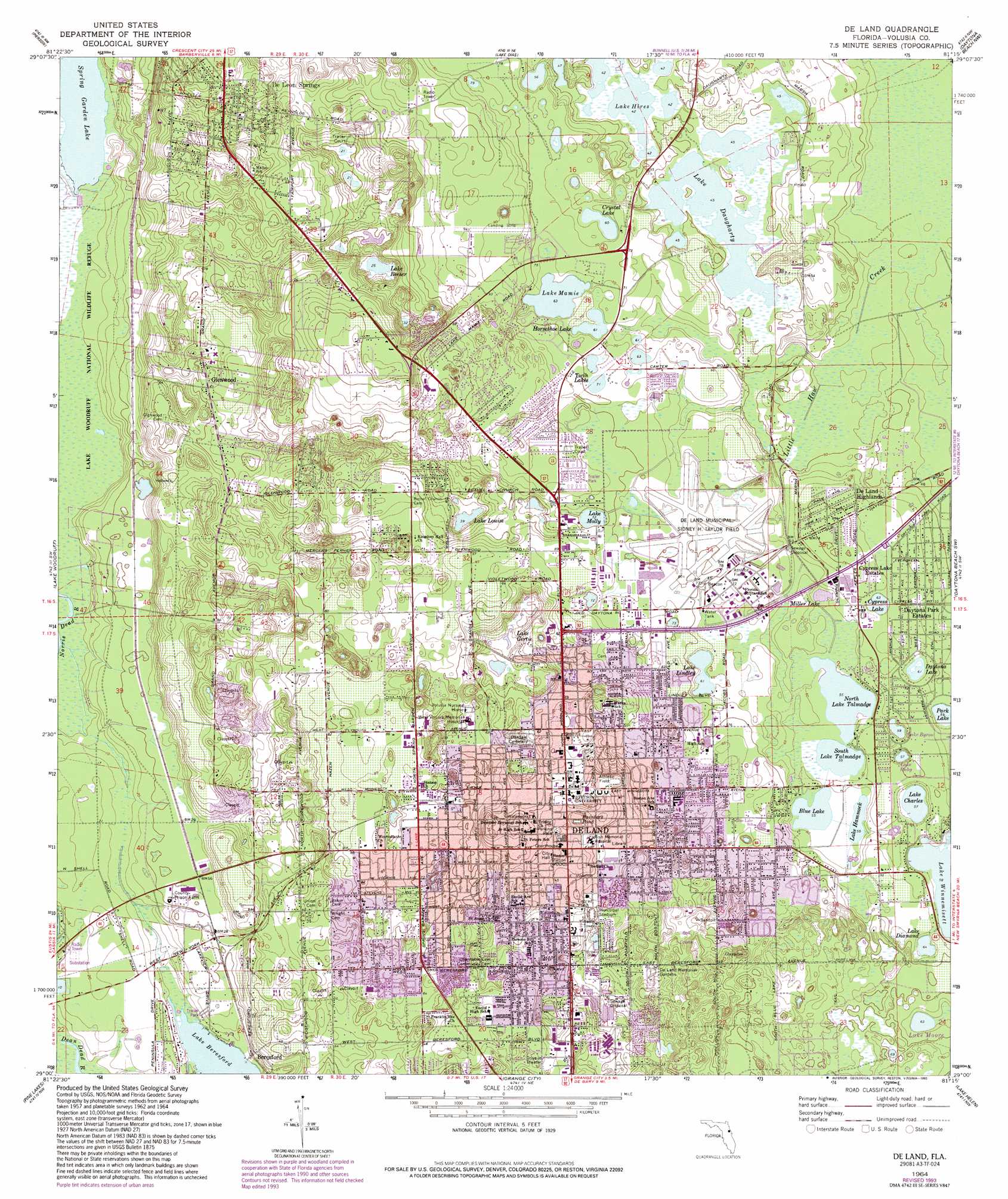
De Land Topo Map Florida
To zoom in, hover over the map of De Land
USGS Topo Quad 29081a3 - 1:24,000 scale
| Topo Map Name: | De Land |
| USGS Topo Quad ID: | 29081a3 |
| Print Size: | ca. 21 1/4" wide x 27" high |
| Southeast Coordinates: | 29° N latitude / 81.25° W longitude |
| Map Center Coordinates: | 29.0625° N latitude / 81.3125° W longitude |
| U.S. State: | FL |
| Filename: | O29081A3.jpg |
| Download Map JPG Image: | De Land topo map 1:24,000 scale |
| Map Type: | Topographic |
| Topo Series: | 7.5´ |
| Map Scale: | 1:24,000 |
| Source of Map Images: | United States Geological Survey (USGS) |
| Alternate Map Versions: |
De Land FL 1964, updated 1965 Download PDF Buy paper map De Land FL 1964, updated 1972 Download PDF Buy paper map De Land FL 1964, updated 1981 Download PDF Buy paper map De Land FL 1964, updated 1993 Download PDF Buy paper map DeLand FL 2012 Download PDF Buy paper map DeLand FL 2015 Download PDF Buy paper map |
1:24,000 Topo Quads surrounding De Land
Welaka Se |
Seville |
Codys Corner |
Favoretta |
Ormond Beach |
Astor |
Pierson |
Lake Dias |
Daytona Beach Nw |
Daytona Beach |
Alexander Springs |
Lake Woodruff |
De Land |
Daytona Beach Sw |
Samsula |
Paisley |
Pine Lakes |
Orange City |
Lake Helen |
Lake Ashby |
Sorrento |
Sanford Sw |
Sanford |
Osteen |
Osceola |
> Back to 29081a1 at 1:100,000 scale
> Back to 29080a1 at 1:250,000 scale
> Back to U.S. Topo Maps home
De Land topo map: Gazetteer
De Land: Airports
Bob Lee Flight Strip elevation 27m 88′De Land Municipal-Sidney H Taylor Field elevation 21m 68′
West Volusia Memorial Hospital Heliport elevation 22m 72′
West Volusia Memorial Hospital Helistop elevation 23m 75′
De Land: Guts
Dean Dead River elevation 1m 3′De Land: Lakes
Blue Lake elevation 16m 52′Cypress Lake elevation 19m 62′
Horseshoe Lake elevation 19m 62′
Lake Byron elevation 18m 59′
Lake Charles elevation 17m 55′
Lake Crystal elevation 18m 59′
Lake Daugharty elevation 13m 42′
Lake Daytona elevation 19m 62′
Lake Diamond elevation 19m 62′
Lake Gertie elevation 9m 29′
Lake Hammock elevation 16m 52′
Lake Hires elevation 13m 42′
Lake Lindley elevation 18m 59′
Lake Louise elevation 12m 39′
Lake Mamie elevation 19m 62′
Lake Molly elevation 22m 72′
Lake Moore elevation 19m 62′
Lake North Talmadge elevation 16m 52′
Lake Reeser elevation 7m 22′
Lake Ruby elevation 17m 55′
Lake South Talmadge elevation 16m 52′
Lake Winnemisett elevation 17m 55′
Miller Lake elevation 16m 52′
North Lake Talmadge elevation 16m 52′
Painters Pond elevation 7m 22′
Park Lake elevation 18m 59′
South Lake Talmadge elevation 16m 52′
Spring Garden Lake elevation 0m 0′
Twin Lakes elevation 22m 72′
De Land: Parks
Chisholm Field elevation 11m 36′Conrad Field (historical) elevation 16m 52′
Earl Brown Park elevation 9m 29′
Hester Park elevation 10m 32′
Page Field (historical) elevation 18m 59′
Sperling Sporting Complex elevation 21m 68′
Stetson Soccer Complex elevation 12m 39′
De Land: Populated Places
A Better Place Mobile Home Park elevation 10m 32′A Better Place Phase III Mobile Home Park elevation 11m 36′
Applegate Estates Mobile Home Park elevation 28m 91′
Beresford elevation 5m 16′
Brookwood Mobile Home Park elevation 12m 39′
Cypress Lake Estates elevation 22m 72′
De Land elevation 12m 39′
De Land Highlands elevation 22m 72′
De Leon Springs elevation 15m 49′
Deland Municipal Trailer Park elevation 12m 39′
Fernwood Mobile Home Park elevation 27m 88′
Glenwood elevation 26m 85′
Hawthorne Hills of Deland Mobile Home Park elevation 15m 49′
Hidden Hills Mobile Home Park elevation 18m 59′
Hidden Valley Park Mobile Home Park elevation 15m 49′
Lakeview Terrace Mobile Home Park elevation 5m 16′
Lingering Lane Mobile Home Park elevation 23m 75′
Meadowlea Estates Mobile Home Park elevation 21m 68′
North De Land elevation 24m 78′
Orangewood Mobile Home Park elevation 26m 85′
Palm Mobile Home Park elevation 28m 91′
Phoenix Estates Mobile Home Park elevation 23m 75′
Raintree Village Mobile Home Park elevation 31m 101′
Sago Palm Mobile Home Park elevation 29m 95′
Sha De Land Mobile Home Park elevation 10m 32′
Tallahasse - Yuchi (historical) elevation 8m 26′
The Oaks Mobile Home Park elevation 27m 88′
Town and Country Mobile Home Park elevation 9m 29′
West De Land elevation 15m 49′
Whisperwood Manufactured Home Park elevation 26m 85′
De Land: Post Offices
De Leon Springs Post Office elevation 12m 39′DeLand Post Office elevation 18m 59′
Glenwood Post Office elevation 24m 78′
De Land digital topo map on disk
Buy this De Land topo map showing relief, roads, GPS coordinates and other geographical features, as a high-resolution digital map file on DVD: