Lake Mary Topo Map Florida
To zoom in, hover over the map of Lake Mary
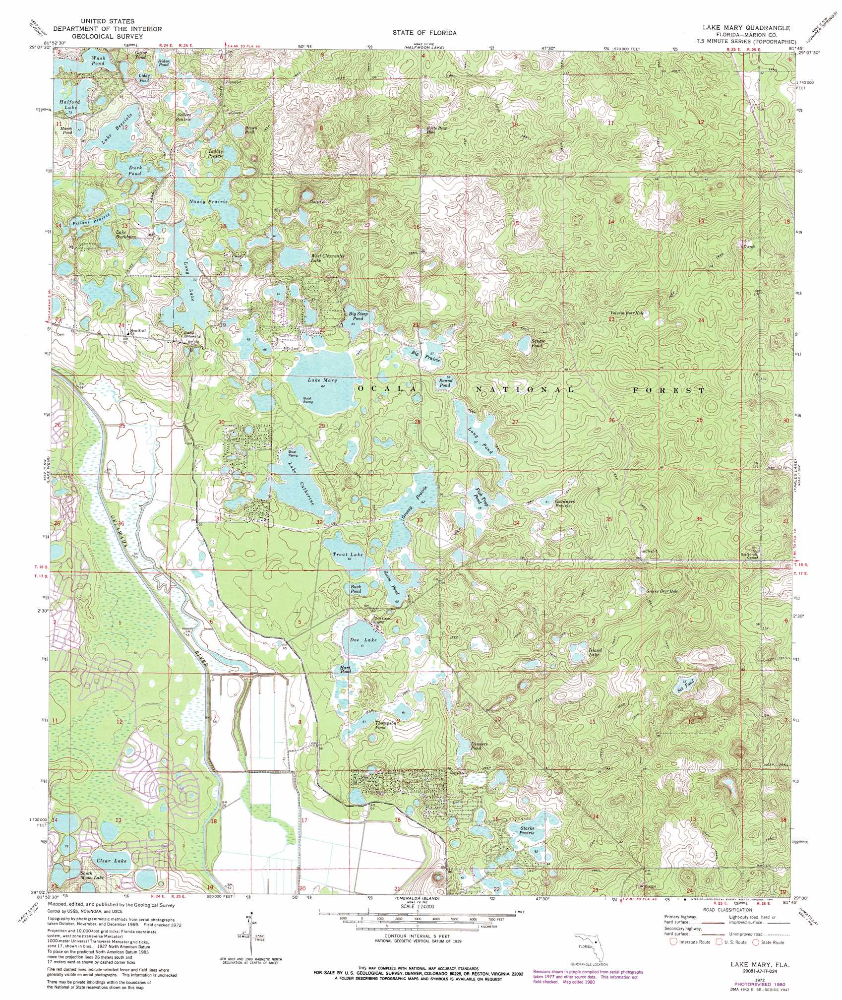
USGS Topo Quad 29081a7 - 1:24,000 scale
| Topo Map Name: | Lake Mary |
| USGS Topo Quad ID: | 29081a7 |
| Print Size: | ca. 21 1/4" wide x 27" high |
| Southeast Coordinates: | 29° N latitude / 81.75° W longitude |
| Map Center Coordinates: | 29.0625° N latitude / 81.8125° W longitude |
| U.S. State: | FL |
| Filename: | O29081A7.jpg |
| Download Map JPG Image: | Lake Mary topo map 1:24,000 scale |
| Map Type: | Topographic |
| Topo Series: | 7.5´ |
| Map Scale: | 1:24,000 |
| Source of Map Images: | United States Geological Survey (USGS) |
| Alternate Map Versions: |
Lake Mary FL 1972, updated 1973 Download PDF Buy paper map Lake Mary FL 1972, updated 1981 Download PDF Buy paper map Lake Mary FL 1972, updated 1987 Download PDF Buy paper map Lake Mary FL 1994, updated 1998 Download PDF Buy paper map Lake Mary FL 2012 Download PDF Buy paper map Lake Mary FL 2015 Download PDF Buy paper map |
| FStopo: | US Forest Service topo Lake Mary is available: Download FStopo PDF Download FStopo TIF |
1:24,000 Topo Quads surrounding Lake Mary
Anthony |
Fort Mccoy |
Lake Kerr |
Salt Springs |
Welaka Se |
Ocala East |
Lynne |
Halfmoon Lake |
Juniper Springs |
Astor |
Belleview |
Lake Weir |
Lake Mary |
Farles Lake |
Alexander Springs |
Oxford |
Lady Lake |
Emeralda Island |
Umatilla |
Paisley |
Wildwood |
Leesburg West |
Leesburg East |
Eustis |
Sorrento |
> Back to 29081a1 at 1:100,000 scale
> Back to 29080a1 at 1:250,000 scale
> Back to U.S. Topo Maps home
Lake Mary topo map: Gazetteer
Lake Mary: Basins
Forts Bear Hole elevation 17m 55′Greens Bear Hole elevation 16m 52′
Lake Mary: Flats
Gardners Prairie elevation 15m 49′Indian Prairie elevation 22m 72′
Nancy Prairie elevation 18m 59′
Pillans Prairie elevation 20m 65′
Sellers Prairie elevation 18m 59′
Lake Mary: Lakes
Aiden Pond elevation 17m 55′Big Prairie elevation 17m 55′
Big Steep Pond elevation 18m 59′
Brown Pond elevation 17m 55′
Buck Pond elevation 19m 62′
Clear Lake elevation 22m 72′
Dinners Pond elevation 17m 55′
Doe Lake elevation 18m 59′
Duck Pond elevation 20m 65′
Fish Trap Pond elevation 17m 55′
Gator Pond elevation 19m 62′
Grassy Prairie elevation 19m 62′
Halford Lake elevation 22m 72′
Hart Pond elevation 19m 62′
Island Lake elevation 16m 52′
Lake Bessiola elevation 22m 72′
Lake Buckhorn elevation 20m 65′
Lake Catherine elevation 19m 62′
Lake Mary elevation 19m 62′
Liddy Pond elevation 18m 59′
Long Lake elevation 21m 68′
Long Pond elevation 17m 55′
Marsh Pond elevation 23m 75′
Round Pond elevation 17m 55′
Set Pond elevation 16m 52′
South Moon Lake elevation 21m 68′
Squaw Pond elevation 16m 52′
Starks Prairie elevation 19m 62′
Swim Pond elevation 19m 62′
Thompson Pond elevation 18m 59′
Trout Lake elevation 19m 62′
Volusia Bear Hole elevation 16m 52′
Wash Pond elevation 22m 72′
West Clearwater Lake elevation 17m 55′
Lake Mary: Populated Places
Big Scrub elevation 22m 72′Forest Lakes Park elevation 19m 62′
Lake Mary: Trails
Prairie Trail elevation 24m 78′Lake Mary digital topo map on disk
Buy this Lake Mary topo map showing relief, roads, GPS coordinates and other geographical features, as a high-resolution digital map file on DVD: