Astor Topo Map Florida
To zoom in, hover over the map of Astor
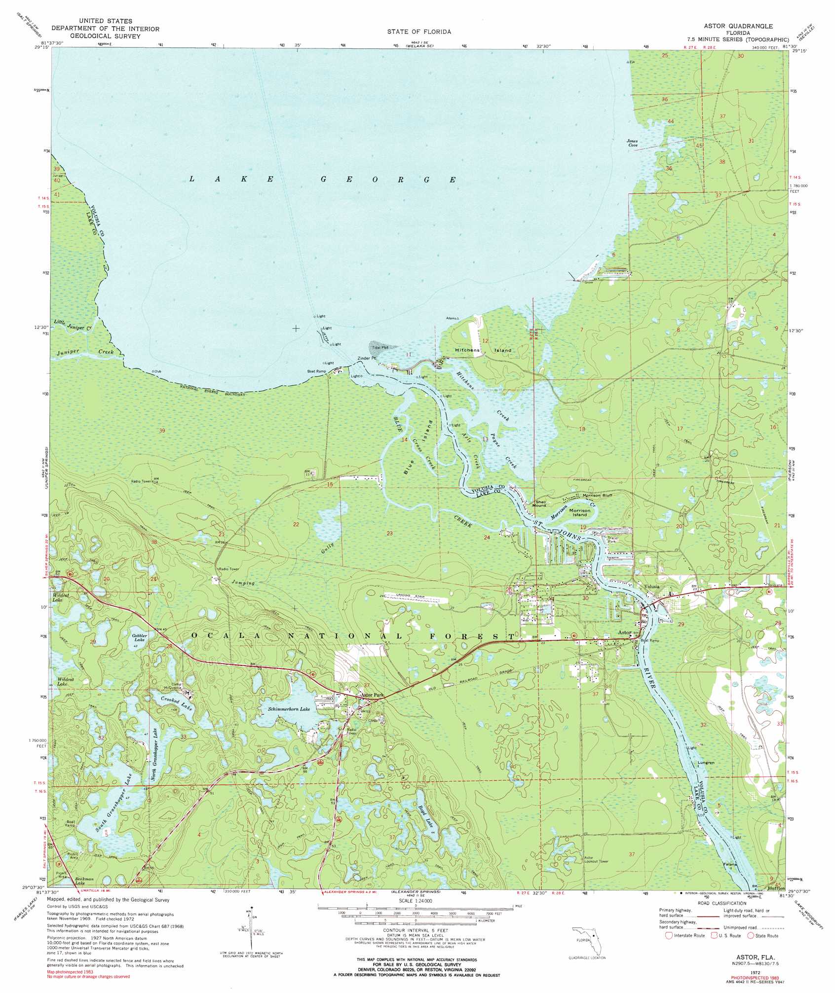
USGS Topo Quad 29081b5 - 1:24,000 scale
| Topo Map Name: | Astor |
| USGS Topo Quad ID: | 29081b5 |
| Print Size: | ca. 21 1/4" wide x 27" high |
| Southeast Coordinates: | 29.125° N latitude / 81.5° W longitude |
| Map Center Coordinates: | 29.1875° N latitude / 81.5625° W longitude |
| U.S. State: | FL |
| Filename: | O29081B5.jpg |
| Download Map JPG Image: | Astor topo map 1:24,000 scale |
| Map Type: | Topographic |
| Topo Series: | 7.5´ |
| Map Scale: | 1:24,000 |
| Source of Map Images: | United States Geological Survey (USGS) |
| Alternate Map Versions: |
Astor FL 1972, updated 1973 Download PDF Buy paper map Astor FL 1972, updated 1990 Download PDF Buy paper map Astor FL 1972, updated 1990 Download PDF Buy paper map Astor FL 2012 Download PDF Buy paper map Astor FL 2015 Download PDF Buy paper map |
| FStopo: | US Forest Service topo Astor is available: Download FStopo PDF Download FStopo TIF |
1:24,000 Topo Quads surrounding Astor
Lake Delancy |
Welaka |
Crescent City |
Saint Johns Park |
Bunnell |
Lake Kerr |
Salt Springs |
Welaka Se |
Seville |
Codys Corner |
Halfmoon Lake |
Juniper Springs |
Astor |
Pierson |
Lake Dias |
Lake Mary |
Farles Lake |
Alexander Springs |
Lake Woodruff |
De Land |
Emeralda Island |
Umatilla |
Paisley |
Pine Lakes |
Orange City |
> Back to 29081a1 at 1:100,000 scale
> Back to 29080a1 at 1:250,000 scale
> Back to U.S. Topo Maps home
Astor topo map: Gazetteer
Astor: Bars
Volusia Bar elevation 0m 0′Astor: Bays
Hitchens Creek elevation 0m 0′Jones Cove elevation 0m 0′
Payne Creek elevation 0m 0′
Astor: Bends
Morrison Creek elevation 0m 0′Astor: Channels
Cross Creek elevation 0m 0′Astor: Cliffs
Morrison Bluff elevation 1m 3′Astor: Islands
Blue Island elevation 0m 0′Falana Island elevation 0m 0′
Hitchens Island elevation 1m 3′
Lungren Island elevation 0m 0′
Morrison Island elevation 1m 3′
Astor: Lakes
Boyd Lake elevation 13m 42′Crooked Lake elevation 14m 45′
Gobbler Lake elevation 13m 42′
North Grasshopper Lake elevation 14m 45′
Schimmerhorn Lake elevation 14m 45′
South Grasshopper Lake elevation 14m 45′
Astor: Parks
Astor Recreation Park elevation 6m 19′Beakman Lake Recreation Area elevation 16m 52′
Astor: Populated Places
A and B Mobile Home Park elevation 3m 9′Astor elevation 1m 3′
Astor Park elevation 14m 45′
Blairs Jungle Den Mobile Home Park elevation 1m 3′
Bluffton elevation 3m 9′
Manhatten elevation 1m 3′
Volusia elevation 5m 16′
Astor: Post Offices
Astor Post Office elevation 5m 16′Astor: Streams
Axle Creek elevation 0m 0′Blue Creek elevation 0m 0′
Jumping Gully elevation 0m 0′
Juniper Creek elevation 0m 0′
Little Juniper Creek elevation 0m 0′
Astor: Summits
Shell Mound elevation 2m 6′Astor digital topo map on disk
Buy this Astor topo map showing relief, roads, GPS coordinates and other geographical features, as a high-resolution digital map file on DVD: