Ormond Beach Topo Map Florida
To zoom in, hover over the map of Ormond Beach
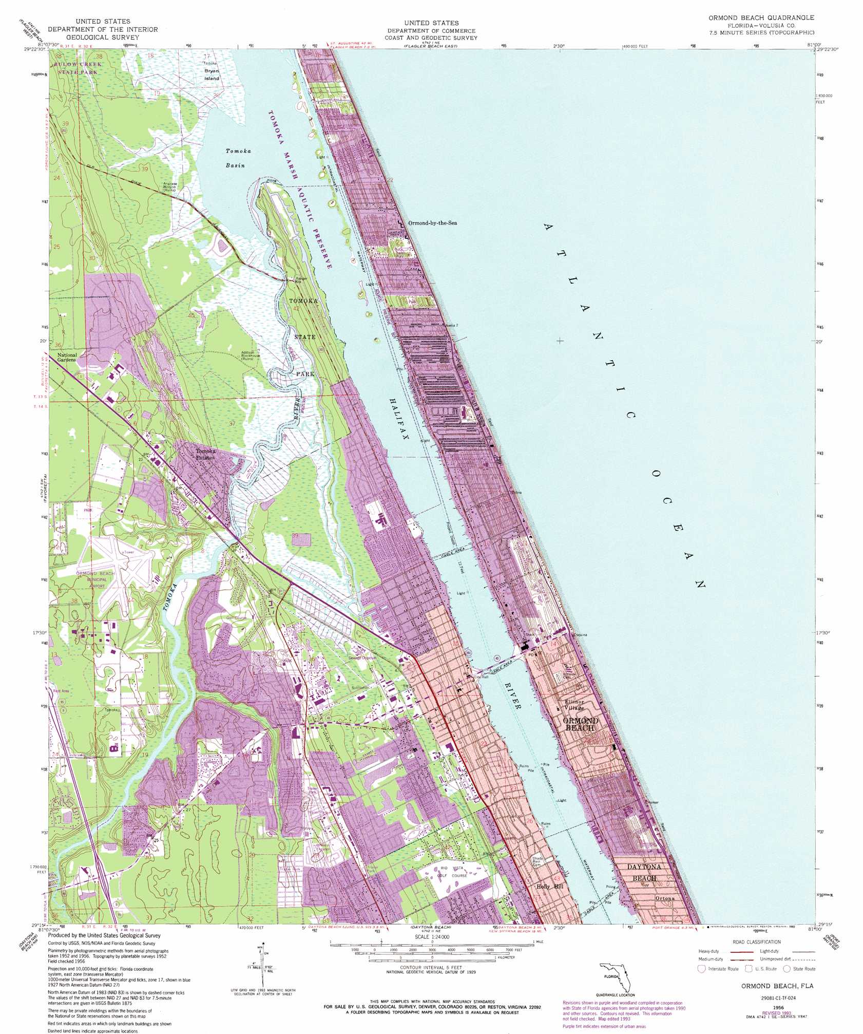
USGS Topo Quad 29081c1 - 1:24,000 scale
| Topo Map Name: | Ormond Beach |
| USGS Topo Quad ID: | 29081c1 |
| Print Size: | ca. 21 1/4" wide x 27" high |
| Southeast Coordinates: | 29.25° N latitude / 81° W longitude |
| Map Center Coordinates: | 29.3125° N latitude / 81.0625° W longitude |
| U.S. State: | FL |
| Filename: | O29081C1.jpg |
| Download Map JPG Image: | Ormond Beach topo map 1:24,000 scale |
| Map Type: | Topographic |
| Topo Series: | 7.5´ |
| Map Scale: | 1:24,000 |
| Source of Map Images: | United States Geological Survey (USGS) |
| Alternate Map Versions: |
Ormond Beach FL 1956, updated 1960 Download PDF Buy paper map Ormond Beach FL 1956, updated 1972 Download PDF Buy paper map Ormond Beach FL 1956, updated 1981 Download PDF Buy paper map Ormond Beach FL 1956, updated 1993 Download PDF Buy paper map Ormond Beach FL 2012 Download PDF Buy paper map Ormond Beach FL 2015 Download PDF Buy paper map |
1:24,000 Topo Quads surrounding Ormond Beach
Espanola |
Beverly Beach |
|||
Bunnell |
Flagler Beach West |
Flagler Beach East |
||
Codys Corner |
Favoretta |
Ormond Beach |
||
Lake Dias |
Daytona Beach Nw |
Daytona Beach |
Port Orange |
|
De Land |
Daytona Beach Sw |
Samsula |
New Smyrna Beach |
> Back to 29081a1 at 1:100,000 scale
> Back to 29080a1 at 1:250,000 scale
> Back to U.S. Topo Maps home
Ormond Beach topo map: Gazetteer
Ormond Beach: Airports
Ormond Beach Municipal Airport elevation 8m 26′Ormond Beach: Bays
Tomoka Basin elevation 0m 0′Ormond Beach: Islands
Bryan Island elevation 0m 0′Ormond Beach: Parks
Addison Blockhouse Historic State Park elevation 0m 0′Bicentennial Park elevation 4m 13′
Ormond Beach Sports Complex elevation 8m 26′
Tomoka State Park elevation 4m 13′
Ormond Beach: Populated Places
Arroyo Mobile Home Park elevation 8m 26′Bear Creek Mobile Home Park elevation 6m 19′
Camelot Mobile Home Park elevation 11m 36′
El Ray Trailer Park elevation 2m 6′
Ellinor Village elevation 4m 13′
Granada Mobile Home Park elevation 3m 9′
Holiday Village Mobile Home Park elevation 7m 22′
Kurras Mobile Village elevation 8m 26′
Life Mobile Home Park elevation 9m 29′
Ormond Beach elevation 2m 6′
Ormond-by-the-Sea elevation 4m 13′
Ortona elevation 4m 13′
Perrywood Villa Mobile Home Community elevation 2m 6′
Ridgecrest Mobile Home Park elevation 1m 3′
Shady Oaks Mobile Home Park elevation 7m 22′
Shangri La Mobile Villa elevation 7m 22′
Sweetgum Mobile Home Park elevation 8m 26′
Tomoka Estates elevation 6m 19′
Westwood Mobile Home Park elevation 10m 32′
Ormond Beach: Post Offices
Ormond Beach Post Office elevation 4m 13′Ormond Beach Post Office (historical) elevation 2m 6′
U S Contract Post Office 32176 elevation 6m 19′
U S Post Office elevation 8m 26′
Ormond Beach: Streams
Groover Branch elevation 0m 0′Little Tomoka River elevation 0m 0′
Tomoka River elevation 0m 0′
Ormond Beach digital topo map on disk
Buy this Ormond Beach topo map showing relief, roads, GPS coordinates and other geographical features, as a high-resolution digital map file on DVD: