Fort Mccoy Topo Map Florida
To zoom in, hover over the map of Fort Mccoy
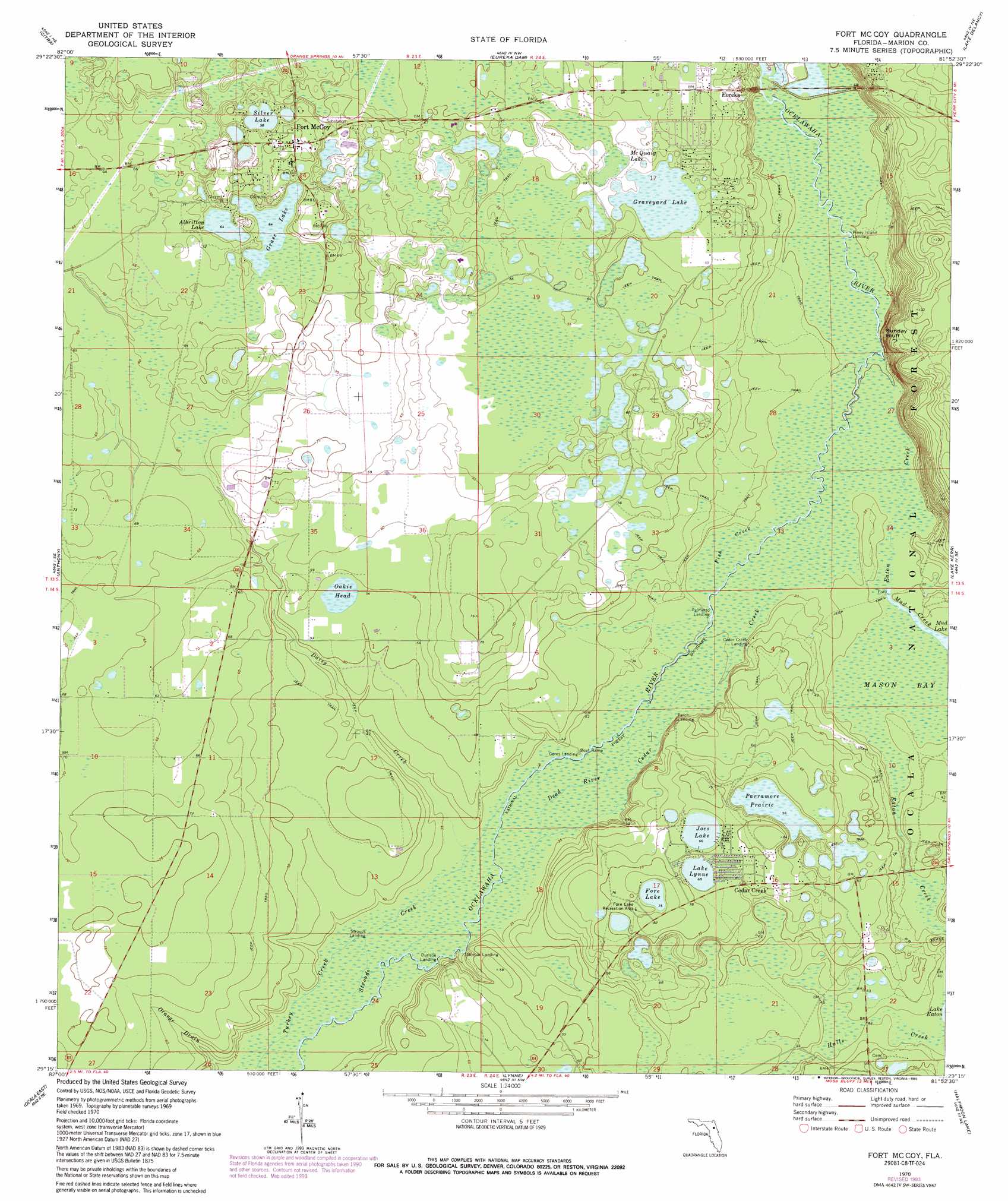
USGS Topo Quad 29081c8 - 1:24,000 scale
| Topo Map Name: | Fort Mccoy |
| USGS Topo Quad ID: | 29081c8 |
| Print Size: | ca. 21 1/4" wide x 27" high |
| Southeast Coordinates: | 29.25° N latitude / 81.875° W longitude |
| Map Center Coordinates: | 29.3125° N latitude / 81.9375° W longitude |
| U.S. State: | FL |
| Filename: | O29081C8.jpg |
| Download Map JPG Image: | Fort Mccoy topo map 1:24,000 scale |
| Map Type: | Topographic |
| Topo Series: | 7.5´ |
| Map Scale: | 1:24,000 |
| Source of Map Images: | United States Geological Survey (USGS) |
| Alternate Map Versions: |
Ft McCoy FL 1970, updated 1973 Download PDF Buy paper map Fort Mc Coy FL 1970, updated 1990 Download PDF Buy paper map Fort Mc Coy FL 1970, updated 1993 Download PDF Buy paper map Fort Mc Coy FL 1999, updated 2001 Download PDF Buy paper map Fort McCoy FL 2012 Download PDF Buy paper map Fort McCoy FL 2015 Download PDF Buy paper map |
| FStopo: | US Forest Service topo Fort McCoy is available: Download FStopo PDF Download FStopo TIF |
1:24,000 Topo Quads surrounding Fort Mccoy
Rochelle |
Hawthorne |
Keuka |
Rodman |
Satsuma |
Mcintosh |
Citra |
Eureka Dam |
Lake Delancy |
Welaka |
Reddick |
Anthony |
Fort Mccoy |
Lake Kerr |
Salt Springs |
Ocala West |
Ocala East |
Lynne |
Halfmoon Lake |
Juniper Springs |
Shady |
Belleview |
Lake Weir |
Lake Mary |
Farles Lake |
> Back to 29081a1 at 1:100,000 scale
> Back to 29080a1 at 1:250,000 scale
> Back to U.S. Topo Maps home
Fort Mccoy topo map: Gazetteer
Fort Mccoy: Channels
Fish Creek elevation 8m 26′Fort Mccoy: Cliffs
Sunday Bluff elevation 30m 98′Fort Mccoy: Guts
Mud Creek elevation 8m 26′Fort Mccoy: Lakes
Albritton Lake elevation 19m 62′Fore Lake elevation 23m 75′
Grass Lake elevation 19m 62′
Graveyard Lake elevation 16m 52′
Joes Lake elevation 20m 65′
Lake Lynne elevation 20m 65′
McQuaig Lake elevation 16m 52′
Silver Lake elevation 17m 55′
Fort Mccoy: Parks
Cougar Park elevation 23m 75′Fore Lake Recreation Area elevation 24m 78′
Gore's Landing Park elevation 10m 32′
Fort Mccoy: Populated Places
Cedar Creek elevation 21m 68′Eureka elevation 16m 52′
Fort McCoy elevation 23m 75′
Fort Mccoy: Post Offices
Fort McCoy Post Office elevation 22m 72′Fort Mccoy: Streams
Cedar Creek elevation 8m 26′Daisy Creek elevation 10m 32′
Dead River elevation 10m 32′
Eaton Creek elevation 7m 22′
Strouds Creek elevation 10m 32′
Turkey Creek elevation 10m 32′
Fort Mccoy: Swamps
Mason Bay elevation 8m 26′Oakie Head elevation 16m 52′
Parramore Prairie elevation 17m 55′
Fort Mccoy digital topo map on disk
Buy this Fort Mccoy topo map showing relief, roads, GPS coordinates and other geographical features, as a high-resolution digital map file on DVD: