Bunnell Topo Map Florida
To zoom in, hover over the map of Bunnell
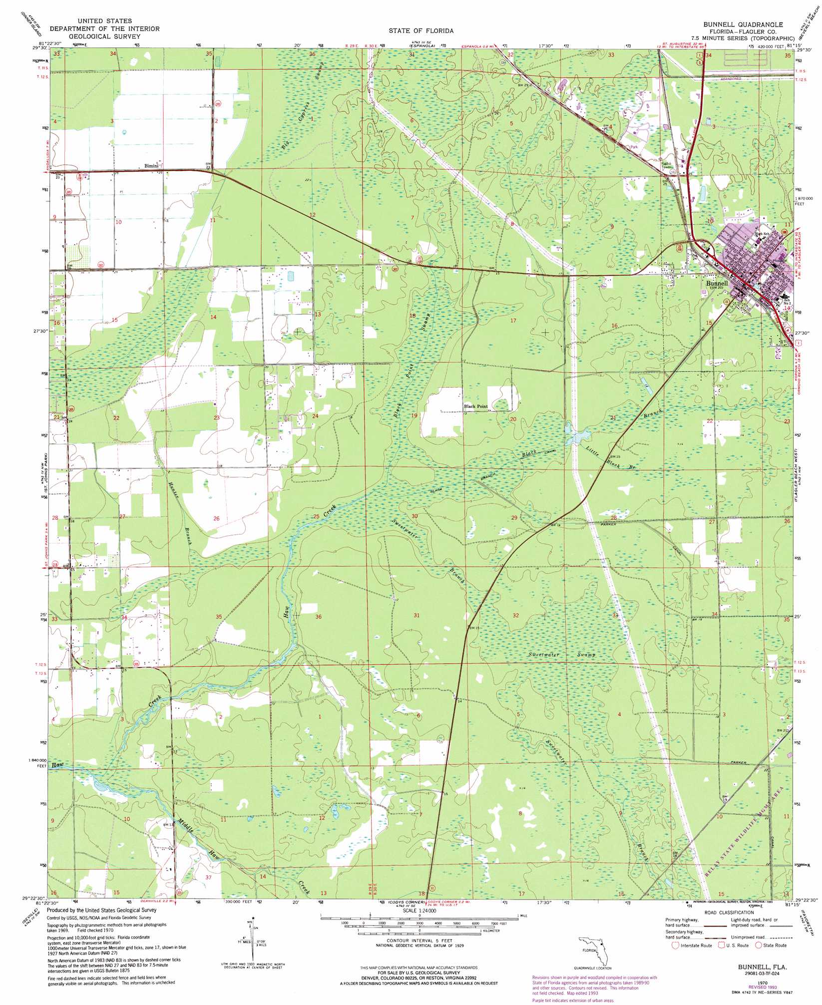
USGS Topo Quad 29081d3 - 1:24,000 scale
| Topo Map Name: | Bunnell |
| USGS Topo Quad ID: | 29081d3 |
| Print Size: | ca. 21 1/4" wide x 27" high |
| Southeast Coordinates: | 29.375° N latitude / 81.25° W longitude |
| Map Center Coordinates: | 29.4375° N latitude / 81.3125° W longitude |
| U.S. State: | FL |
| Filename: | O29081D3.jpg |
| Download Map JPG Image: | Bunnell topo map 1:24,000 scale |
| Map Type: | Topographic |
| Topo Series: | 7.5´ |
| Map Scale: | 1:24,000 |
| Source of Map Images: | United States Geological Survey (USGS) |
| Alternate Map Versions: |
Bunnell FL 1970, updated 1973 Download PDF Buy paper map Bunnell FL 1970, updated 1987 Download PDF Buy paper map Bunnell FL 1970, updated 1993 Download PDF Buy paper map Bunnell FL 2012 Download PDF Buy paper map Bunnell FL 2015 Download PDF Buy paper map |
1:24,000 Topo Quads surrounding Bunnell
Hastings |
Spuds |
Dinner Island Ne |
Matanzas Inlet |
|
San Mateo |
Dinner Island |
Espanola |
Beverly Beach |
|
Crescent City |
Saint Johns Park |
Bunnell |
Flagler Beach West |
Flagler Beach East |
Welaka Se |
Seville |
Codys Corner |
Favoretta |
Ormond Beach |
Astor |
Pierson |
Lake Dias |
Daytona Beach Nw |
Daytona Beach |
> Back to 29081a1 at 1:100,000 scale
> Back to 29080a1 at 1:250,000 scale
> Back to U.S. Topo Maps home
Bunnell topo map: Gazetteer
Bunnell: Airports
Memorial Hospital-Flagler Helistop elevation 6m 19′Bunnell: Canals
Black Branch Canal elevation 1m 3′Bunnell: Populated Places
Bimini elevation 6m 19′Black Point elevation 3m 9′
Bunnell elevation 6m 19′
Bunnell: Post Offices
Bunnell Post Office elevation 6m 19′Bunnell: Streams
Black Branch elevation 1m 3′Hunter Branch elevation 1m 3′
Little Black Branch elevation 3m 9′
Middle Haw Creek elevation 1m 3′
Sweetwater Branch elevation 1m 3′
Bunnell: Swamps
Big Cypress Swamp elevation 7m 22′Black Point Swamp elevation 0m 0′
Sweetwater Swamp elevation 2m 6′
Bunnell digital topo map on disk
Buy this Bunnell topo map showing relief, roads, GPS coordinates and other geographical features, as a high-resolution digital map file on DVD: