Eureka Dam Topo Map Florida
To zoom in, hover over the map of Eureka Dam
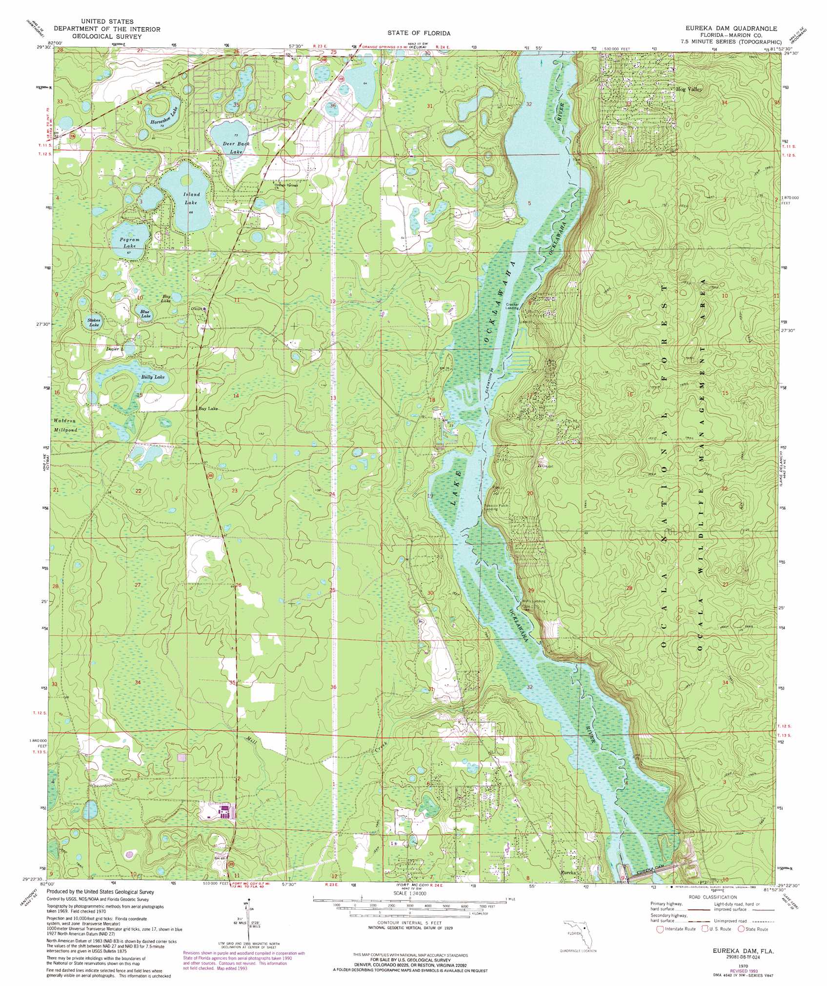
USGS Topo Quad 29081d8 - 1:24,000 scale
| Topo Map Name: | Eureka Dam |
| USGS Topo Quad ID: | 29081d8 |
| Print Size: | ca. 21 1/4" wide x 27" high |
| Southeast Coordinates: | 29.375° N latitude / 81.875° W longitude |
| Map Center Coordinates: | 29.4375° N latitude / 81.9375° W longitude |
| U.S. State: | FL |
| Filename: | O29081D8.jpg |
| Download Map JPG Image: | Eureka Dam topo map 1:24,000 scale |
| Map Type: | Topographic |
| Topo Series: | 7.5´ |
| Map Scale: | 1:24,000 |
| Source of Map Images: | United States Geological Survey (USGS) |
| Alternate Map Versions: |
Eureka Dam FL 1970, updated 1982 Download PDF Buy paper map Eureka Dam FL 1970, updated 1993 Download PDF Buy paper map Eureka Dam FL 2012 Download PDF Buy paper map Eureka Dam FL 2015 Download PDF Buy paper map |
| FStopo: | US Forest Service topo Eureka Dam is available: Download FStopo PDF Download FStopo TIF |
1:24,000 Topo Quads surrounding Eureka Dam
Orange Heights |
Melrose |
Putnam Hall |
Baywood |
Palatka |
Rochelle |
Hawthorne |
Keuka |
Rodman |
Satsuma |
Mcintosh |
Citra |
Eureka Dam |
Lake Delancy |
Welaka |
Reddick |
Anthony |
Fort Mccoy |
Lake Kerr |
Salt Springs |
Ocala West |
Ocala East |
Lynne |
Halfmoon Lake |
Juniper Springs |
> Back to 29081a1 at 1:100,000 scale
> Back to 29080a1 at 1:250,000 scale
> Back to U.S. Topo Maps home
Eureka Dam topo map: Gazetteer
Eureka Dam: Dams
Eureka Dam elevation 10m 32′Eureka Dam: Lakes
Bay Lake elevation 19m 62′Blue Lake elevation 19m 62′
Bully Lake elevation 19m 62′
Deer Back Lake elevation 22m 72′
Dozier Lake elevation 22m 72′
Horseshoe Lake elevation 21m 68′
Island Lake elevation 20m 65′
Pegram Lake elevation 20m 65′
Stokes Lake elevation 22m 72′
Eureka Dam: Parks
Fort McCoy Wildlife Management Area elevation 16m 52′Eureka Dam: Populated Places
Bay Lake elevation 16m 52′Hog Valley elevation 41m 134′
Tobacco Patch Landing elevation 10m 32′
Eureka Dam: Streams
Mill Creek elevation 6m 19′Eureka Dam digital topo map on disk
Buy this Eureka Dam topo map showing relief, roads, GPS coordinates and other geographical features, as a high-resolution digital map file on DVD: