San Mateo Topo Map Florida
To zoom in, hover over the map of San Mateo
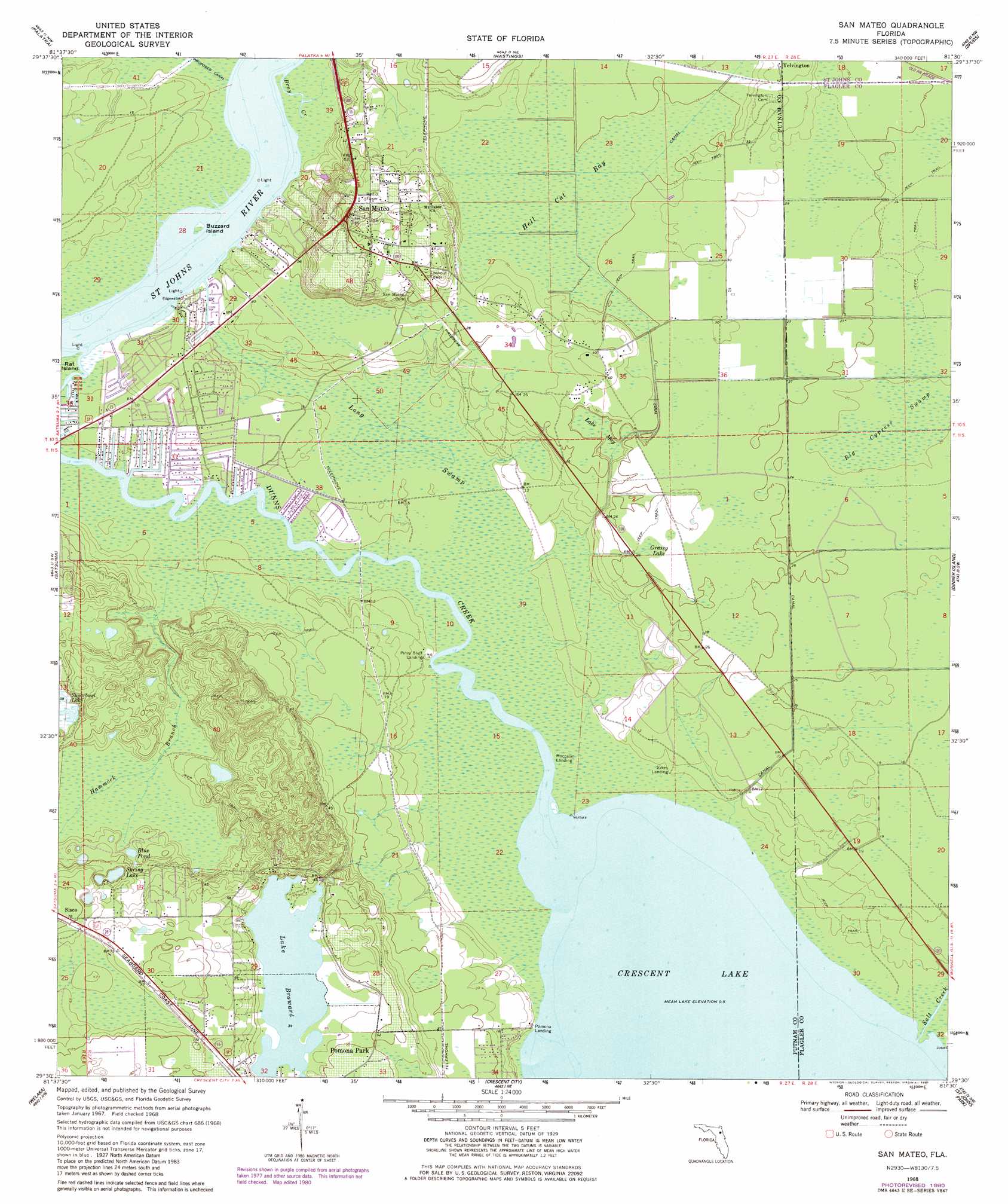
USGS Topo Quad 29081e5 - 1:24,000 scale
| Topo Map Name: | San Mateo |
| USGS Topo Quad ID: | 29081e5 |
| Print Size: | ca. 21 1/4" wide x 27" high |
| Southeast Coordinates: | 29.5° N latitude / 81.5° W longitude |
| Map Center Coordinates: | 29.5625° N latitude / 81.5625° W longitude |
| U.S. State: | FL |
| Filename: | O29081E5.jpg |
| Download Map JPG Image: | San Mateo topo map 1:24,000 scale |
| Map Type: | Topographic |
| Topo Series: | 7.5´ |
| Map Scale: | 1:24,000 |
| Source of Map Images: | United States Geological Survey (USGS) |
| Alternate Map Versions: |
San Mateo FL 1968, updated 1971 Download PDF Buy paper map San Mateo FL 1968, updated 1977 Download PDF Buy paper map San Mateo FL 1968, updated 1981 Download PDF Buy paper map San Mateo FL 2012 Download PDF Buy paper map San Mateo FL 2015 Download PDF Buy paper map |
1:24,000 Topo Quads surrounding San Mateo
Rice Creek |
Bostwick |
Riverdale |
Elkton |
Saint Augustine Beach |
Baywood |
Palatka |
Hastings |
Spuds |
Dinner Island Ne |
Rodman |
Satsuma |
San Mateo |
Dinner Island |
Espanola |
Lake Delancy |
Welaka |
Crescent City |
Saint Johns Park |
Bunnell |
Lake Kerr |
Salt Springs |
Welaka Se |
Seville |
Codys Corner |
> Back to 29081e1 at 1:100,000 scale
> Back to 29080a1 at 1:250,000 scale
> Back to U.S. Topo Maps home
San Mateo topo map: Gazetteer
San Mateo: Bays
Sykes Cove elevation 0m 0′Willow Cove elevation 0m 0′
San Mateo: Capes
Shell Hill Point elevation 0m 0′Willow Point elevation 0m 0′
San Mateo: Channels
Hammock Branch elevation 9m 29′San Mateo: Guts
Bray Creek elevation 0m 0′San Mateo: Islands
Buzzard Island elevation 0m 0′San Mateo: Lakes
Blue Pond elevation 11m 36′Lake Broward elevation 12m 39′
Spring Lake elevation 13m 42′
San Mateo: Populated Places
Pomona Park elevation 13m 42′San Mateo elevation 22m 72′
Sutherlands Still elevation 1m 3′
San Mateo: Streams
Salt Creek elevation 0m 0′San Mateo: Swamps
Big Cypress Swamp elevation 6m 19′Grassy Lake elevation 8m 26′
Hell Cat Bay elevation 7m 22′
Lake May elevation 5m 16′
Long Swamp elevation 1m 3′
San Mateo digital topo map on disk
Buy this San Mateo topo map showing relief, roads, GPS coordinates and other geographical features, as a high-resolution digital map file on DVD: