Saint Augustine Topo Map Florida
To zoom in, hover over the map of Saint Augustine
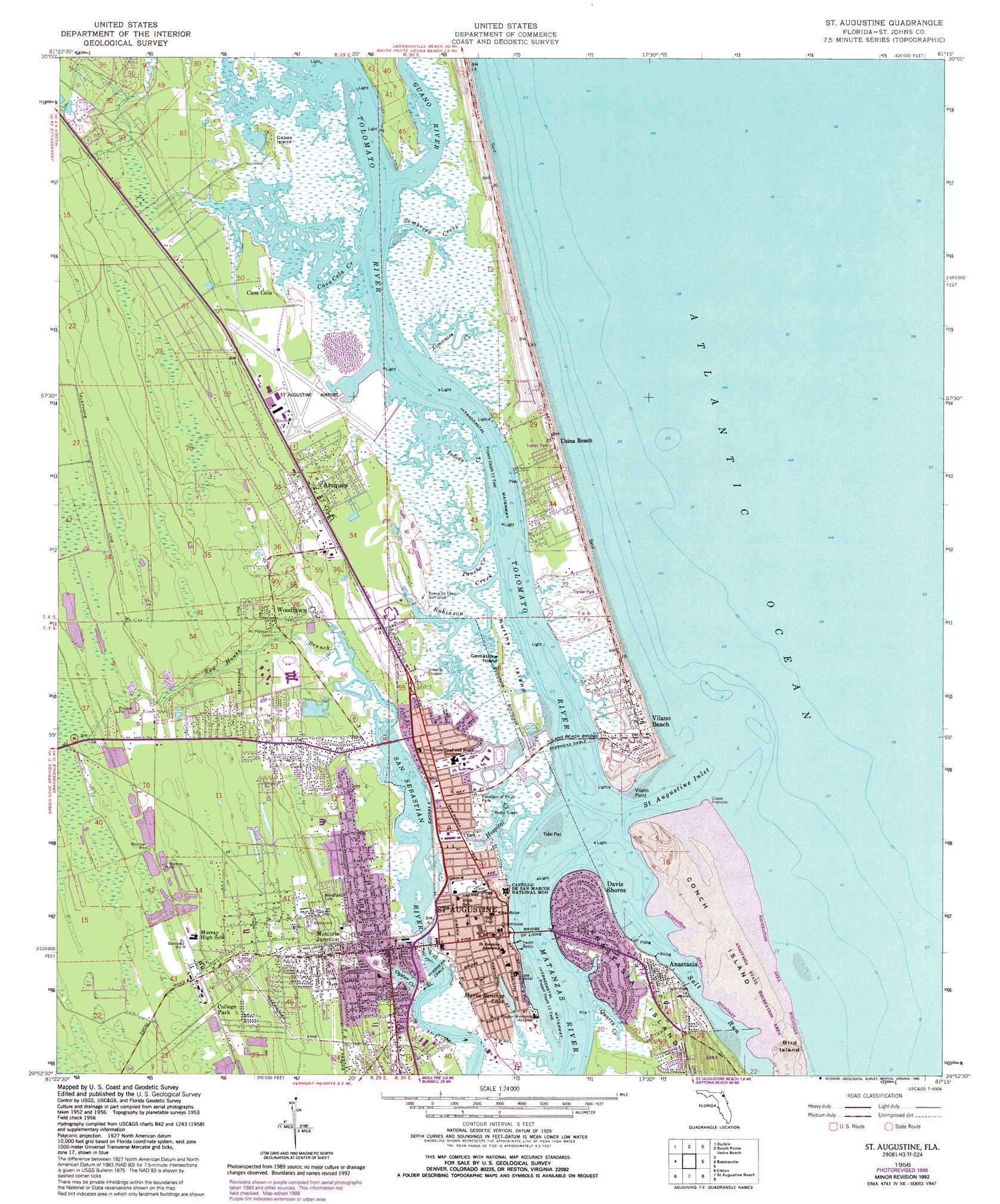
USGS Topo Quad 29081h3 - 1:24,000 scale
| Topo Map Name: | Saint Augustine |
| USGS Topo Quad ID: | 29081h3 |
| Print Size: | ca. 21 1/4" wide x 27" high |
| Southeast Coordinates: | 29.875° N latitude / 81.25° W longitude |
| Map Center Coordinates: | 29.9375° N latitude / 81.3125° W longitude |
| U.S. State: | FL |
| Filename: | O29081H3.jpg |
| Download Map JPG Image: | Saint Augustine topo map 1:24,000 scale |
| Map Type: | Topographic |
| Topo Series: | 7.5´ |
| Map Scale: | 1:24,000 |
| Source of Map Images: | United States Geological Survey (USGS) |
| Alternate Map Versions: |
St. Augustine FL 1937 Download PDF Buy paper map St. Augustine FL 1956, updated 1961 Download PDF Buy paper map St. Augustine FL 1956, updated 1972 Download PDF Buy paper map St. Augustine FL 1956, updated 1988 Download PDF Buy paper map St. Augustine FL 1956, updated 1992 Download PDF Buy paper map Saint Augustine FL 2012 Download PDF Buy paper map Saint Augustine FL 2015 Download PDF Buy paper map |
1:24,000 Topo Quads surrounding Saint Augustine
Bayard |
Palm Valley |
Mickler Landing |
||
Orangedale |
Durbin |
South Ponte Vedra Beach |
||
Picolata |
Bakersville |
Saint Augustine |
||
Riverdale |
Elkton |
Saint Augustine Beach |
||
Hastings |
Spuds |
Dinner Island Ne |
Matanzas Inlet |
> Back to 29081e1 at 1:100,000 scale
> Back to 29080a1 at 1:250,000 scale
> Back to U.S. Topo Maps home
Saint Augustine topo map: Gazetteer
Saint Augustine: Airports
Saint Augustine Airport elevation 1m 3′Saint Augustine: Bridges
Bridge of Lions elevation 0m 0′Vilano Beach Bridge elevation 0m 0′
Saint Augustine: Capes
French Cape elevation 0m 0′Vilano Point elevation 0m 0′
Saint Augustine: Channels
Saint Augustine Inlet elevation 0m 0′Saint Augustine: Islands
Capos Island elevation 3m 9′Comatchie Island elevation 1m 3′
Conch Island elevation 2m 6′
Kurths Island elevation 0m 0′
Saint Augustine: Lakes
Maria Sanchez Lake elevation 0m 0′Saint Augustine: Parks
Castillo de San Marcos National Monument elevation 0m 0′Fountain of Youth Park elevation 1m 3′
Llambias House elevation 2m 6′
Saint Augustine Town Plan Historic District elevation 1m 3′
Saint Augustine: Populated Places
Anastasia elevation 5m 16′Araquey elevation 2m 6′
Bernards Trailer Park elevation 4m 13′
Breeze Trailer Park elevation 6m 19′
Brentwood Mobile Home Park elevation 8m 26′
Casa Cola elevation 2m 6′
College Park elevation 10m 32′
Coquina Oaks Mobile Home elevation 4m 13′
Davis Shores elevation 1m 3′
Dobbs Mobile Home Park elevation 4m 13′
El Rey Residential Court elevation 4m 13′
Frog Hollow Court Mobile Home Park elevation 3m 9′
Gaines Mobile Home Park elevation 10m 32′
Graceland Mobile Home Park elevation 10m 32′
Kingsley Mobile Home Park elevation 1m 3′
Lazy C Mobile Home Park elevation 10m 32′
Moultrie Junction elevation 3m 9′
Newt's Trailer Park elevation 3m 9′
Nombre de Dios (historical) elevation 1m 3′
Saint Augustine elevation 0m 0′
Saint Augustine Family Park Mobile Home Park elevation 10m 32′
Seven Pines Mobile Home Park elevation 10m 32′
Shady Pines II Mobile Home Park elevation 12m 39′
Siesta Mobile Home Park elevation 10m 32′
Usina Beach elevation 5m 16′
Vilano Beach elevation 3m 9′
Villano Beach elevation 3m 9′
Woodlawn elevation 3m 9′
Saint Augustine: Post Offices
Saint Augustine Post Office elevation 1m 3′Saint Augustine: Streams
Casa Cola Creek elevation 0m 0′Guana River elevation 0m 0′
Hospital Creek elevation 0m 0′
Indian Creek elevation 0m 0′
Matanzas River elevation 0m 0′
Oyster Creek elevation 0m 0′
Pancho Creek elevation 0m 0′
Quarry Creek elevation 0m 0′
Red House Branch elevation 1m 3′
Robinson Creek elevation 0m 0′
Salt Run elevation 0m 0′
Sombrero Creek elevation 0m 0′
Tolomato River elevation 0m 0′
Ximanies Creek elevation 0m 0′
Saint Augustine digital topo map on disk
Buy this Saint Augustine topo map showing relief, roads, GPS coordinates and other geographical features, as a high-resolution digital map file on DVD: