Green Cove Springs Topo Map Florida
To zoom in, hover over the map of Green Cove Springs
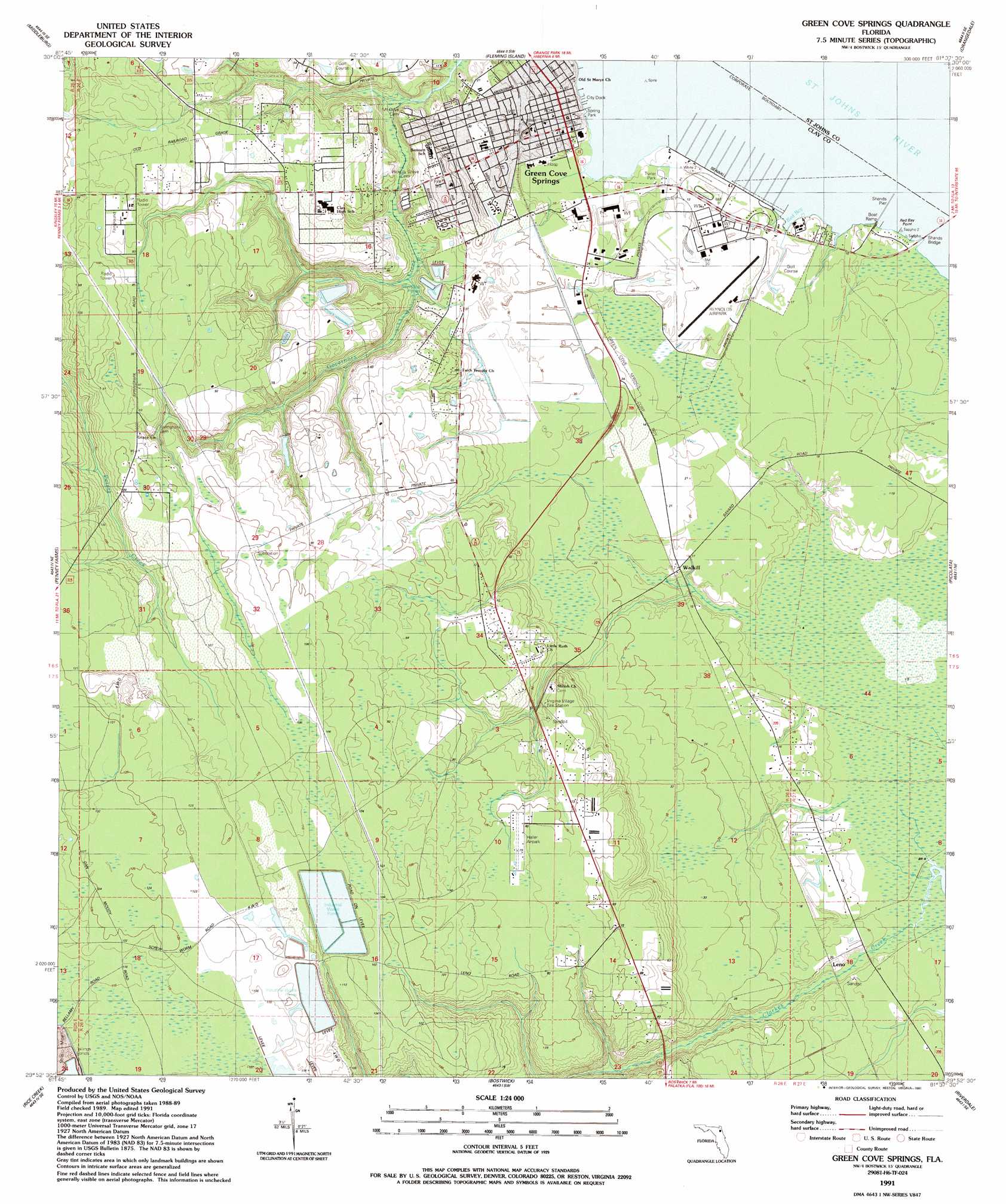
USGS Topo Quad 29081h6 - 1:24,000 scale
| Topo Map Name: | Green Cove Springs |
| USGS Topo Quad ID: | 29081h6 |
| Print Size: | ca. 21 1/4" wide x 27" high |
| Southeast Coordinates: | 29.875° N latitude / 81.625° W longitude |
| Map Center Coordinates: | 29.9375° N latitude / 81.6875° W longitude |
| U.S. State: | FL |
| Filename: | O29081H6.jpg |
| Download Map JPG Image: | Green Cove Springs topo map 1:24,000 scale |
| Map Type: | Topographic |
| Topo Series: | 7.5´ |
| Map Scale: | 1:24,000 |
| Source of Map Images: | United States Geological Survey (USGS) |
| Alternate Map Versions: |
Green Cove Springs FL 1949, updated 1953 Download PDF Buy paper map Green Cove Springs FL 1949, updated 1972 Download PDF Buy paper map Green Cove Springs FL 1949, updated 1980 Download PDF Buy paper map Green Cove Springs FL 1949, updated 1987 Download PDF Buy paper map Green Cove Springs FL 1991, updated 1991 Download PDF Buy paper map Green Cove Springs FL 2012 Download PDF Buy paper map Green Cove Springs FL 2015 Download PDF Buy paper map |
1:24,000 Topo Quads surrounding Green Cove Springs
Fiftone |
Jacksonville Heights |
Orange Park |
Bayard |
Palm Valley |
Middleburg Sw |
Middleburg |
Fleming Island |
Orangedale |
Durbin |
Kingsley |
Penney Farms |
Green Cove Springs |
Picolata |
Bakersville |
Gold Head Branch |
Rice Creek |
Bostwick |
Riverdale |
Elkton |
Putnam Hall |
Baywood |
Palatka |
Hastings |
Spuds |
> Back to 29081e1 at 1:100,000 scale
> Back to 29080a1 at 1:250,000 scale
> Back to U.S. Topo Maps home
Green Cove Springs topo map: Gazetteer
Green Cove Springs: Airports
Haller Airpark elevation 23m 75′Reynolds Airpark elevation 6m 19′
Green Cove Springs: Bays
Red Bay elevation 0m 0′Green Cove Springs: Capes
Red Bay Point elevation 0m 0′Green Cove Springs: Parks
Spring Park elevation 4m 13′Tot Lot Park elevation 5m 16′
Green Cove Springs: Populated Places
Green Cove Springs elevation 5m 16′Idlewild Trailer Park elevation 8m 26′
Johns Mobile Home Park elevation 16m 52′
Leno elevation 4m 13′
Rio Vista Trailer Park elevation 2m 6′
Walkill elevation 5m 16′
Green Cove Springs: Post Offices
Green Cove Springs Post Office elevation 6m 19′Green Cove Springs: Streams
Red Bay Creek elevation 0m 0′Green Cove Springs digital topo map on disk
Buy this Green Cove Springs topo map showing relief, roads, GPS coordinates and other geographical features, as a high-resolution digital map file on DVD: