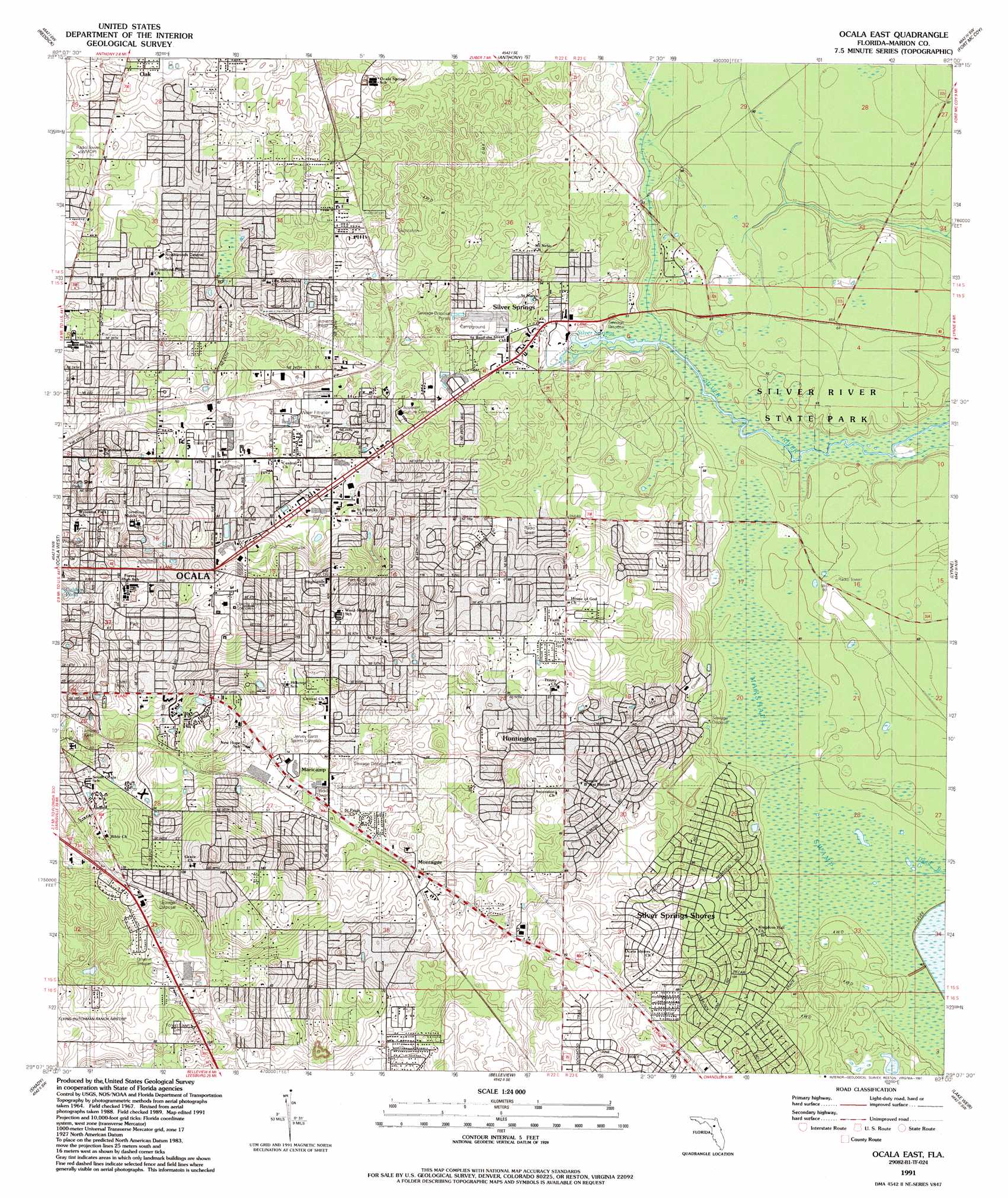
Ocala East Topo Map Florida
To zoom in, hover over the map of Ocala East
USGS Topo Quad 29082b1 - 1:24,000 scale
| Topo Map Name: | Ocala East |
| USGS Topo Quad ID: | 29082b1 |
| Print Size: | ca. 21 1/4" wide x 27" high |
| Southeast Coordinates: | 29.125° N latitude / 82° W longitude |
| Map Center Coordinates: | 29.1875° N latitude / 82.0625° W longitude |
| U.S. State: | FL |
| Filename: | O29082B1.jpg |
| Download Map JPG Image: | Ocala East topo map 1:24,000 scale |
| Map Type: | Topographic |
| Topo Series: | 7.5´ |
| Map Scale: | 1:24,000 |
| Source of Map Images: | United States Geological Survey (USGS) |
| Alternate Map Versions: |
Ocala East FL 1967, updated 1969 Download PDF Buy paper map Ocala East FL 1991, updated 1991 Download PDF Buy paper map Ocala East FL 2012 Download PDF Buy paper map Ocala East FL 2015 Download PDF Buy paper map |
1:24,000 Topo Quads surrounding Ocala East
Flemington |
Mcintosh |
Citra |
Eureka Dam |
Lake Delancy |
Fairfield |
Reddick |
Anthony |
Fort Mccoy |
Lake Kerr |
Cotton Plant |
Ocala West |
Ocala East |
Lynne |
Halfmoon Lake |
Dunnellon Se |
Shady |
Belleview |
Lake Weir |
Lake Mary |
Stokes Ferry |
Lake Panasoffkee Nw |
Oxford |
Lady Lake |
Emeralda Island |
> Back to 29082a1 at 1:100,000 scale
> Back to 29082a1 at 1:250,000 scale
> Back to U.S. Topo Maps home
Ocala East topo map: Gazetteer
Ocala East: Parks
Ocala-Marion County Veterans Memorial Park elevation 34m 111′Robert F Ritterhoff Park elevation 21m 68′
Silver River State Park elevation 15m 49′
Ocala East: Populated Places
Arbors of Ocala Mobile Home Park elevation 21m 68′Blue Skies Estates Mobile Home Park elevation 24m 78′
Cala Springs Mobile Home Park elevation 20m 65′
Camp Roosevelt elevation 35m 114′
Cherry Hill Mobile Home Park elevation 35m 114′
Country Aire Mobile Home Park elevation 20m 65′
Craft Travel Trailer Park elevation 15m 49′
Huntington elevation 26m 85′
Lindale Mobile Home Park elevation 19m 62′
Maricamp elevation 21m 68′
Montague elevation 24m 78′
Nautilus Trailer Park elevation 34m 111′
Rolling Greens Mobile Home Park elevation 28m 91′
Silver Springs elevation 15m 49′
Southeast Side Mobile Home Park elevation 23m 75′
Spanish Oaks Mobile Home Park elevation 16m 52′
Spanish Palm Estates Mobile Home Park elevation 22m 72′
Twin Oaks Mobile Home Park elevation 34m 111′
Wagon Wheel Mobile Home Park elevation 23m 75′
Ocala East: Post Offices
Maricamp Road Branch Post Office elevation 23m 75′Maricamp Road Branch Post Office elevation 24m 78′
Silver Springs Post Office elevation 15m 49′
Ocala East: Springs
Silver Springs elevation 13m 42′Ocala East digital topo map on disk
Buy this Ocala East topo map showing relief, roads, GPS coordinates and other geographical features, as a high-resolution digital map file on DVD: