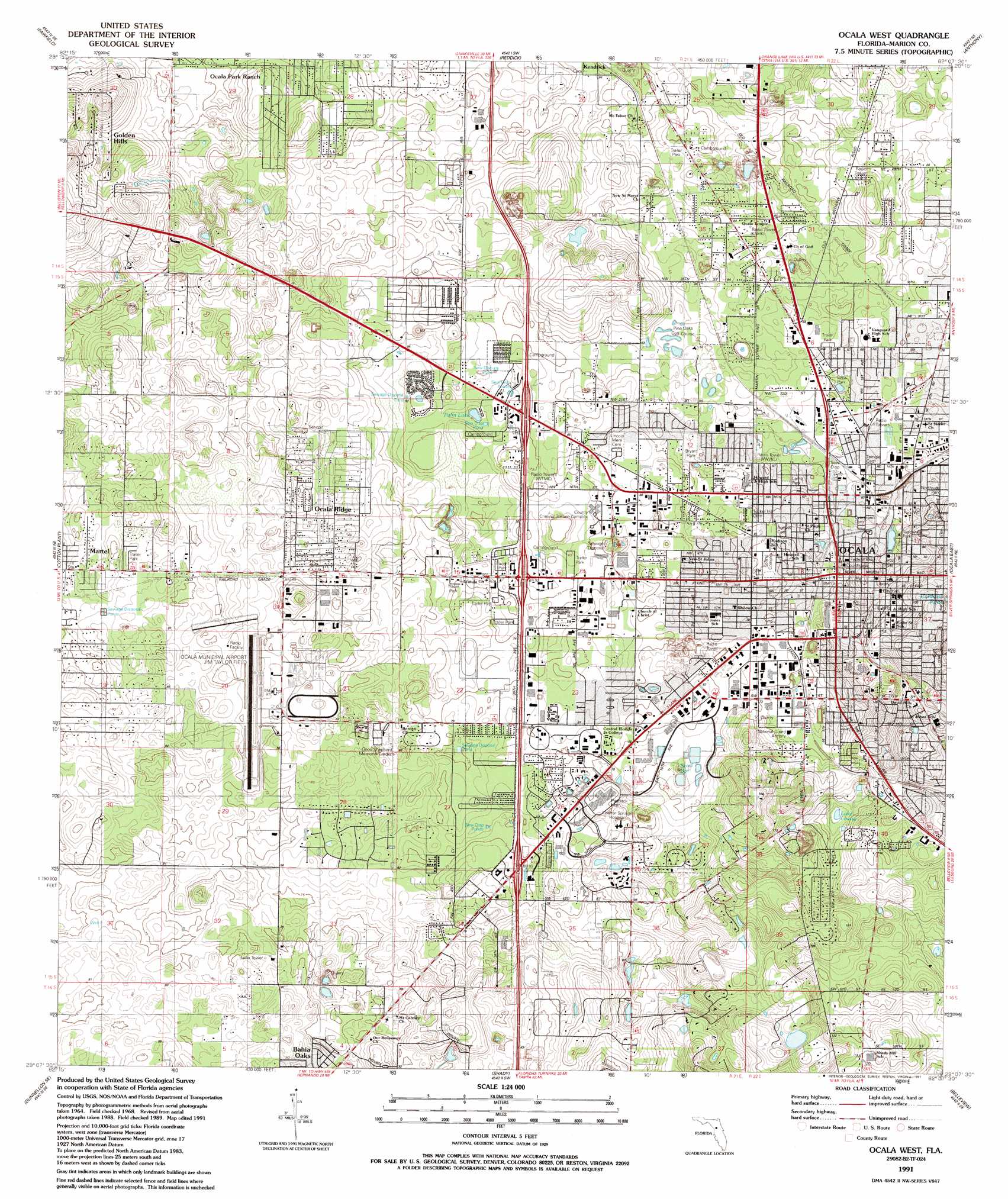
Ocala West Topo Map Florida
To zoom in, hover over the map of Ocala West
USGS Topo Quad 29082b2 - 1:24,000 scale
| Topo Map Name: | Ocala West |
| USGS Topo Quad ID: | 29082b2 |
| Print Size: | ca. 21 1/4" wide x 27" high |
| Southeast Coordinates: | 29.125° N latitude / 82.125° W longitude |
| Map Center Coordinates: | 29.1875° N latitude / 82.1875° W longitude |
| U.S. State: | FL |
| Filename: | O29082B2.jpg |
| Download Map JPG Image: | Ocala West topo map 1:24,000 scale |
| Map Type: | Topographic |
| Topo Series: | 7.5´ |
| Map Scale: | 1:24,000 |
| Source of Map Images: | United States Geological Survey (USGS) |
| Alternate Map Versions: |
Ocala West FL 1968, updated 1969 Download PDF Buy paper map Ocala West FL 1968, updated 1977 Download PDF Buy paper map Ocala West FL 1991, updated 1991 Download PDF Buy paper map Ocala West FL 2012 Download PDF Buy paper map Ocala West FL 2015 Download PDF Buy paper map |
1:24,000 Topo Quads surrounding Ocala West
Williston |
Flemington |
Mcintosh |
Citra |
Eureka Dam |
Morriston |
Fairfield |
Reddick |
Anthony |
Fort Mccoy |
Romeo |
Cotton Plant |
Ocala West |
Ocala East |
Lynne |
Dunnellon |
Dunnellon Se |
Shady |
Belleview |
Lake Weir |
Holder |
Stokes Ferry |
Lake Panasoffkee Nw |
Oxford |
Lady Lake |
> Back to 29082a1 at 1:100,000 scale
> Back to 29082a1 at 1:250,000 scale
> Back to U.S. Topo Maps home
Ocala West topo map: Gazetteer
Ocala West: Airports
Eagles Rest Incorporated Heliport elevation 23m 75′Ocala Heliport elevation 22m 72′
Ocala International Airport-Jim Taylor Field elevation 23m 75′
Ocala Municipal Airport elevation 23m 75′
Ocala West: Lakes
Caldwells Pond elevation 39m 127′Lake Louise elevation 17m 55′
Palm Lake elevation 14m 45′
Ocala West: Parks
Chazal Park elevation 21m 68′Fisher Park elevation 20m 65′
Lamb Park elevation 21m 68′
Lillian F Bryant Park elevation 20m 65′
Northside Park elevation 28m 91′
Toms Park elevation 14m 45′
Tuscawilla Park elevation 19m 62′
Ocala West: Populated Places
Bahia Oaks elevation 27m 88′Country Oaks Mobile Home Park elevation 20m 65′
Country Town Village Mobile Home Park elevation 30m 98′
Dogwood Acres Mobile Home Park elevation 28m 91′
Edgewood Mobile Home Park elevation 20m 65′
Fairfield Village of Ocala Mobile Home Park elevation 27m 88′
Foxwood Farms Mobile Home Park elevation 14m 45′
Golden Hills elevation 31m 101′
Golden Hills Park Mobile Home Park elevation 26m 85′
Happy Acres Mobile Home Park elevation 24m 78′
Martel elevation 26m 85′
Oakcrest Mobile Home Park elevation 22m 72′
Oakwood Mobile Manor Mobile Home Park elevation 21m 68′
Ocala elevation 21m 68′
Ocala Municipal Trailer Park elevation 24m 78′
Ocala Ridge elevation 27m 88′
Ocala Thoroughbred Acres elevation 22m 72′
Penny Park Estates Mobile Home Park elevation 21m 68′
Pine Manor East Mobile Home Park elevation 20m 65′
Pioneer Mobile Home Park elevation 32m 104′
Saddle Oak Club elevation 26m 85′
Saddle Oak Club Mobile Home Park elevation 22m 72′
Shady Grove Mobile Home Park elevation 22m 72′
Sweetwater Oaks Mobile Home Park elevation 23m 75′
The Falls of Ocala Mobile Home Park elevation 25m 82′
West Village Mobile Home Park elevation 19m 62′
Western Mobile Home Park elevation 23m 75′
Westwood Mobile Home Park elevation 24m 78′
White Oaks Mobile Home Park elevation 25m 82′
Ocala West: Post Offices
Ocala Post Office elevation 29m 95′Paddock Branch Post Office elevation 25m 82′
Ocala West: Springs
Scott Spring elevation 18m 59′Ocala West digital topo map on disk
Buy this Ocala West topo map showing relief, roads, GPS coordinates and other geographical features, as a high-resolution digital map file on DVD: