Chiefland Topo Map Florida
To zoom in, hover over the map of Chiefland
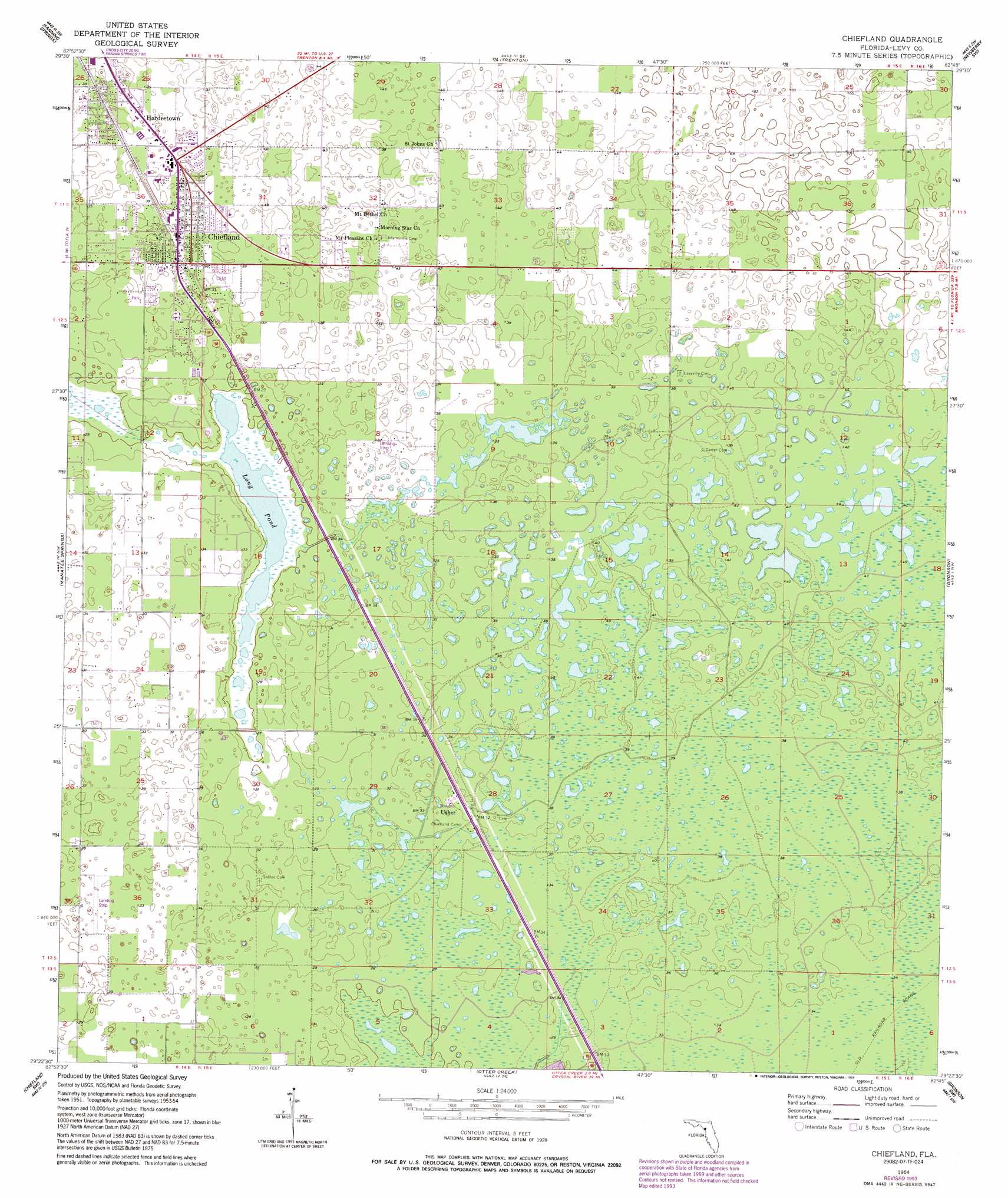
USGS Topo Quad 29082d7 - 1:24,000 scale
| Topo Map Name: | Chiefland |
| USGS Topo Quad ID: | 29082d7 |
| Print Size: | ca. 21 1/4" wide x 27" high |
| Southeast Coordinates: | 29.375° N latitude / 82.75° W longitude |
| Map Center Coordinates: | 29.4375° N latitude / 82.8125° W longitude |
| U.S. State: | FL |
| Filename: | O29082D7.jpg |
| Download Map JPG Image: | Chiefland topo map 1:24,000 scale |
| Map Type: | Topographic |
| Topo Series: | 7.5´ |
| Map Scale: | 1:24,000 |
| Source of Map Images: | United States Geological Survey (USGS) |
| Alternate Map Versions: |
Chiefland FL 1954, updated 1956 Download PDF Buy paper map Chiefland FL 1954, updated 1973 Download PDF Buy paper map Chiefland FL 1954, updated 1988 Download PDF Buy paper map Chiefland FL 1954, updated 1993 Download PDF Buy paper map Chiefland FL 2012 Download PDF Buy paper map Chiefland FL 2015 Download PDF Buy paper map |
1:24,000 Topo Quads surrounding Chiefland
Cross City East |
Wannee |
Fourmile Lake |
Waters Lake |
Newberry |
Eugene |
Suwannee River |
Trenton |
Newberry Sw |
Archer |
Vista |
Manatee Springs |
Chiefland |
Bronson |
Bronson Ne |
East Pass |
Chiefland Sw |
Otter Creek |
Bronson Sw |
Bronson Se |
Cedar Key |
Sumner |
Waccasassa Bay |
Lebanon Station |
Tidewater |
> Back to 29082a1 at 1:100,000 scale
> Back to 29082a1 at 1:250,000 scale
> Back to U.S. Topo Maps home
Chiefland topo map: Gazetteer
Chiefland: Airports
Mills Ranch Airport (historical) elevation 9m 29′Chiefland: Cliffs
Long Pond elevation 7m 22′Chiefland: Lakes
Long Pond elevation 7m 22′Long Pond elevation 7m 22′
Chiefland: Parks
Chiefland High School Football Stadium elevation 11m 36′City of Chiefland Eddie Buie Park elevation 11m 36′
Chiefland: Populated Places
Chiefland elevation 10m 32′Hardeetown elevation 12m 39′
Usher elevation 11m 36′
Chiefland: Post Offices
Chiefland Post Office elevation 11m 36′Chiefland digital topo map on disk
Buy this Chiefland topo map showing relief, roads, GPS coordinates and other geographical features, as a high-resolution digital map file on DVD: