Hawthorne Topo Map Florida
To zoom in, hover over the map of Hawthorne
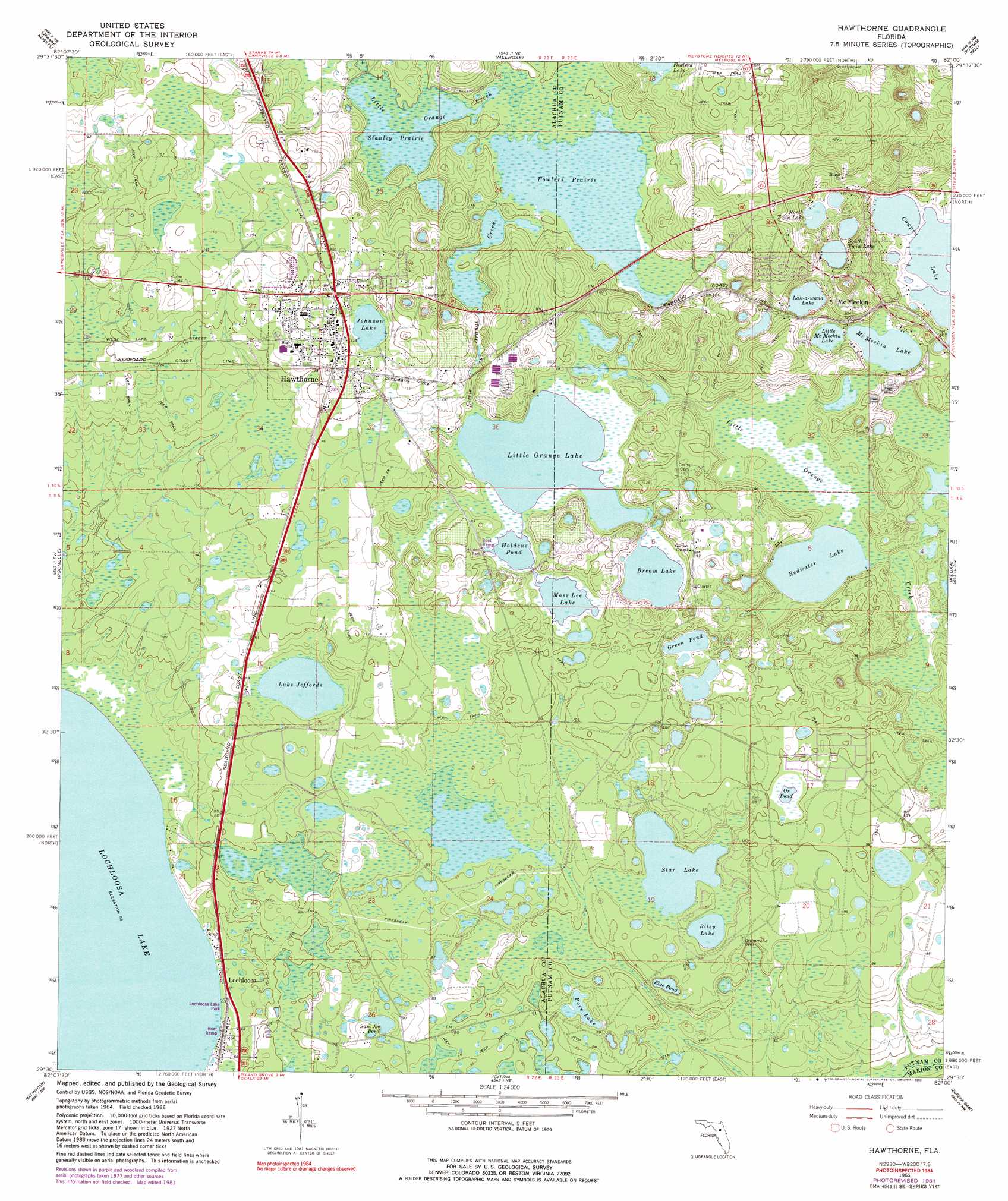
USGS Topo Quad 29082e1 - 1:24,000 scale
| Topo Map Name: | Hawthorne |
| USGS Topo Quad ID: | 29082e1 |
| Print Size: | ca. 21 1/4" wide x 27" high |
| Southeast Coordinates: | 29.5° N latitude / 82° W longitude |
| Map Center Coordinates: | 29.5625° N latitude / 82.0625° W longitude |
| U.S. State: | FL |
| Filename: | O29082E1.jpg |
| Download Map JPG Image: | Hawthorne topo map 1:24,000 scale |
| Map Type: | Topographic |
| Topo Series: | 7.5´ |
| Map Scale: | 1:24,000 |
| Source of Map Images: | United States Geological Survey (USGS) |
| Alternate Map Versions: |
Hawthorne FL 1966, updated 1967 Download PDF Buy paper map Hawthorne FL 1966, updated 1990 Download PDF Buy paper map Hawthorne FL 2012 Download PDF Buy paper map Hawthorne FL 2015 Download PDF Buy paper map |
1:24,000 Topo Quads surrounding Hawthorne
Monteocha |
Waldo |
Keystone Heights |
Gold Head Branch |
Rice Creek |
Gainesville East |
Orange Heights |
Melrose |
Putnam Hall |
Baywood |
Micanopy |
Rochelle |
Hawthorne |
Keuka |
Rodman |
Flemington |
Mcintosh |
Citra |
Eureka Dam |
Lake Delancy |
Fairfield |
Reddick |
Anthony |
Fort Mccoy |
Lake Kerr |
> Back to 29082e1 at 1:100,000 scale
> Back to 29082a1 at 1:250,000 scale
> Back to U.S. Topo Maps home
Hawthorne topo map: Gazetteer
Hawthorne: Flats
Fowlers Prairie elevation 30m 98′Hawthorne: Lakes
Blue Pond elevation 22m 72′Bream Lake elevation 27m 88′
Cowpen Lake elevation 27m 88′
Green Pond elevation 27m 88′
Holdens Pond elevation 27m 88′
Johnson Lake elevation 42m 137′
Lak-a-wana Lake elevation 28m 91′
Lake Issue elevation 28m 91′
Lake Jeffords elevation 25m 82′
Lake Johnson elevation 42m 137′
Little McMeekin Lake elevation 27m 88′
Little Orange Lake elevation 27m 88′
McMeekin Lake elevation 27m 88′
Moss Lee Lake elevation 27m 88′
North Twin Lake elevation 33m 108′
Ox Pond elevation 30m 98′
Pace Lake elevation 24m 78′
Redwater Lake elevation 24m 78′
Riley Lake elevation 24m 78′
Sam Joe Pond elevation 25m 82′
South Twin Lake elevation 31m 101′
Star Lake elevation 24m 78′
Hawthorne: Parks
Hawthorne Recreation Park elevation 44m 144′Hawtorne High School Football Stadium elevation 43m 141′
Holden Park elevation 27m 88′
Lochloosa Lake Park elevation 19m 62′
Hawthorne: Populated Places
Hawthorne elevation 45m 147′Lochloosa elevation 20m 65′
McMeekin elevation 43m 141′
Hawthorne: Post Offices
Hawthorne Post Office elevation 47m 154′Lochloosa Post Office elevation 19m 62′
Hawthorne: Streams
Little Orange Creek elevation 30m 98′Hawthorne: Swamps
Stanley Prairie elevation 30m 98′Hawthorne digital topo map on disk
Buy this Hawthorne topo map showing relief, roads, GPS coordinates and other geographical features, as a high-resolution digital map file on DVD: