Gainesville East Topo Map Florida
To zoom in, hover over the map of Gainesville East
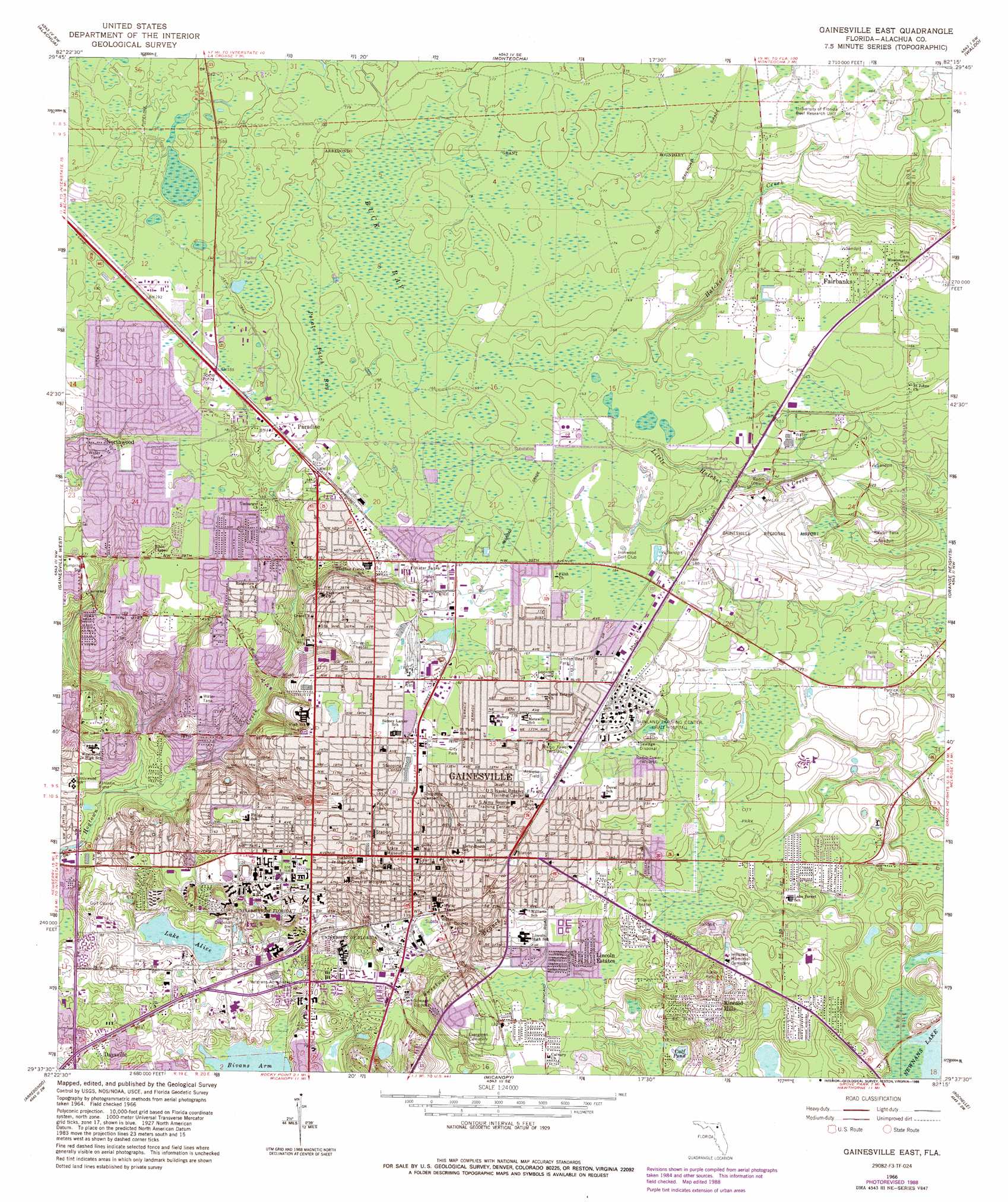
USGS Topo Quad 29082f3 - 1:24,000 scale
| Topo Map Name: | Gainesville East |
| USGS Topo Quad ID: | 29082f3 |
| Print Size: | ca. 21 1/4" wide x 27" high |
| Southeast Coordinates: | 29.625° N latitude / 82.25° W longitude |
| Map Center Coordinates: | 29.6875° N latitude / 82.3125° W longitude |
| U.S. State: | FL |
| Filename: | O29082F3.jpg |
| Download Map JPG Image: | Gainesville East topo map 1:24,000 scale |
| Map Type: | Topographic |
| Topo Series: | 7.5´ |
| Map Scale: | 1:24,000 |
| Source of Map Images: | United States Geological Survey (USGS) |
| Alternate Map Versions: |
Gainesville East FL 1966, updated 1967 Download PDF Buy paper map Gainesville East FL 1966, updated 1972 Download PDF Buy paper map Gainesville East FL 1966, updated 1982 Download PDF Buy paper map Gainesville East FL 1966, updated 1988 Download PDF Buy paper map Gainesville East FL 1994, updated 2000 Download PDF Buy paper map Gainesville East FL 2012 Download PDF Buy paper map Gainesville East FL 2015 Download PDF Buy paper map |
1:24,000 Topo Quads surrounding Gainesville East
Mikesville |
Worthington Springs |
Brooker |
Sampson |
Starke |
High Springs |
Alachua |
Monteocha |
Waldo |
Keystone Heights |
Newberry |
Gainesville West |
Gainesville East |
Orange Heights |
Melrose |
Archer |
Arredondo |
Micanopy |
Rochelle |
Hawthorne |
Bronson Ne |
Williston |
Flemington |
Mcintosh |
Citra |
> Back to 29082e1 at 1:100,000 scale
> Back to 29082a1 at 1:250,000 scale
> Back to U.S. Topo Maps home
Gainesville East topo map: Gazetteer
Gainesville East: Airports
Alachua General Hospital Heliport elevation 45m 147′Gainesville Regional Airport elevation 39m 127′
Shands Cair Heliport elevation 28m 91′
Shands Helistop elevation 28m 91′
University of Florida Heliport elevation 26m 85′
Veterans Administration Medical Center Heliport elevation 28m 91′
Gainesville East: Lakes
Calf Pond elevation 23m 75′Lake Alice elevation 20m 65′
Trout Lake elevation 23m 75′
Gainesville East: Parks
City of Gainesville Northside Park elevation 57m 187′Fred Cone Park elevation 38m 124′
Milton Lewis Stadium elevation 53m 173′
Morningside Nature Center elevation 40m 131′
Smokey Bear Park elevation 52m 170′
T B McPherson Recreation Complex elevation 35m 114′
Westside Recreation Center elevation 28m 91′
Gainesville East: Populated Places
Brittany Estates Mobile Home Park elevation 42m 137′Candlelight Estates Mobile Home Community elevation 52m 170′
Daysville elevation 27m 88′
Fairbanks elevation 51m 167′
Gainesville elevation 54m 177′
Green Grove elevation 35m 114′
Hillcrest Mobile Home Park elevation 48m 157′
Ideal Trailer Park elevation 52m 170′
Kincaid Hills elevation 49m 160′
Kreftwood Estates elevation 33m 108′
Lakeview Estates elevation 23m 75′
Lincoln Estates elevation 38m 124′
Northwood elevation 55m 180′
Paradise elevation 55m 180′
Ruthland elevation 37m 121′
Varsity Mobile Home Villa elevation 48m 157′
Gainesville East: Post Offices
University Post Office elevation 51m 167′Gainesville East: Streams
Little Hatchet Creek elevation 26m 85′Gainesville East: Swamps
Buck Bay elevation 49m 160′Potato Patch Bay elevation 51m 167′
Gainesville East digital topo map on disk
Buy this Gainesville East topo map showing relief, roads, GPS coordinates and other geographical features, as a high-resolution digital map file on DVD: