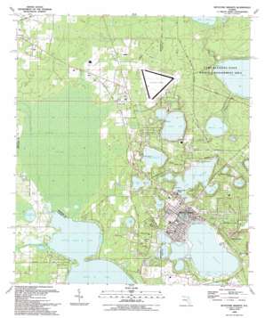
Keystone Heights Topo Map Florida
To zoom in, hover over the map of Keystone Heights
USGS Topo Quad 29082g1 - 1:24,000 scale
| Topo Map Name: | Keystone Heights |
| USGS Topo Quad ID: | 29082g1 |
| Print Size: | ca. 21 1/4" wide x 27" high |
| Southeast Coordinates: | 29.75° N latitude / 82° W longitude |
| Map Center Coordinates: | 29.8125° N latitude / 82.0625° W longitude |
| U.S. State: | FL |
| Filename: | O29082G1.jpg |
| Download Map JPG Image: | Keystone Heights topo map 1:24,000 scale |
| Map Type: | Topographic |
| Topo Series: | 7.5´ |
| Map Scale: | 1:24,000 |
| Source of Map Images: | United States Geological Survey (USGS) |
| Alternate Map Versions: |
Keystone Heights FL 1949, updated 1953 Download PDF Buy paper map Keystone Heights FL 1949, updated 1972 Download PDF Buy paper map Keystone Heights FL 1949, updated 1978 Download PDF Buy paper map Keystone Heights FL 1949, updated 1990 Download PDF Buy paper map Keystone Heights FL 1993, updated 1993 Download PDF Buy paper map Keystone Heights FL 2012 Download PDF Buy paper map Keystone Heights FL 2015 Download PDF Buy paper map |
1:24,000 Topo Quads surrounding Keystone Heights
> Back to 29082e1 at 1:100,000 scale
> Back to 29082a1 at 1:250,000 scale
> Back to U.S. Topo Maps home
Keystone Heights topo map: Gazetteer
Keystone Heights: Airports
Keystone Airpark elevation 57m 187′Keystone Airpark elevation 56m 183′
Keystone Heights: Bays
Brooklyn Bay elevation 33m 108′Keystone Heights: Canals
Santa Fe Canal elevation 45m 147′Keystone Heights: Lakes
Blue Pond elevation 52m 170′Bolt Lake elevation 42m 137′
Camp Crystal Lake elevation 49m 160′
Crystal Lake elevation 33m 108′
Deer Springs Lake elevation 31m 101′
Hickory Pond elevation 47m 154′
Indian Lake elevation 42m 137′
Keystone Lake elevation 36m 118′
Lake Bedford elevation 36m 118′
Lake Brooklyn elevation 34m 111′
Lake Geneva elevation 30m 98′
Little Lake Geneva elevation 49m 160′
Little Santa Fe Lake elevation 43m 141′
Lost Pond elevation 50m 164′
Lowry Lake elevation 40m 131′
Magnolia Lake elevation 38m 124′
Mosquito Lake elevation 43m 141′
Paradise Lake elevation 36m 118′
Perch Pond elevation 52m 170′
Persimmon Pond elevation 31m 101′
Saddlebag Pond elevation 27m 88′
Silver Lake elevation 36m 118′
Keystone Heights: Parks
Keystone Beach elevation 36m 118′Keystone Heights High School Stadium elevation 43m 141′
Magnolia Lake State Park (historical) elevation 46m 150′
McDavid Park elevation 44m 144′
Keystone Heights: Populated Places
Jim Rod Mobile Home Park elevation 35m 114′Keystone Heights elevation 43m 141′
Lake Geneva elevation 42m 137′
Lake Geneva Mobile Home Park elevation 39m 127′
Loch Lommond elevation 42m 137′
Park of the Palms elevation 38m 124′
Santa Fe Beach elevation 43m 141′
Theressa elevation 49m 160′
Keystone Heights: Post Offices
Keystone Heights Post Office elevation 44m 144′Lake Geneva Post Office elevation 36m 118′
Keystone Heights: Streams
Alligator Creek elevation 38m 124′Double Run Creek elevation 45m 147′
Keystone Heights: Swamps
Santa Fe Swamp elevation 45m 147′Keystone Heights digital topo map on disk
Buy this Keystone Heights topo map showing relief, roads, GPS coordinates and other geographical features, as a high-resolution digital map file on DVD:


