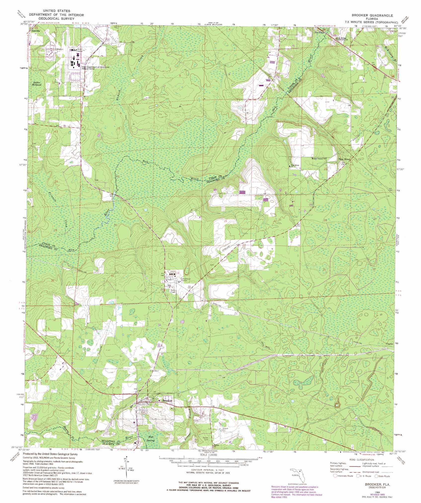
Brooker Topo Map Florida
To zoom in, hover over the map of Brooker
USGS Topo Quad 29082h3 - 1:24,000 scale
| Topo Map Name: | Brooker |
| USGS Topo Quad ID: | 29082h3 |
| Print Size: | ca. 21 1/4" wide x 27" high |
| Southeast Coordinates: | 29.875° N latitude / 82.25° W longitude |
| Map Center Coordinates: | 29.9375° N latitude / 82.3125° W longitude |
| U.S. State: | FL |
| Filename: | O29082H3.jpg |
| Download Map JPG Image: | Brooker topo map 1:24,000 scale |
| Map Type: | Topographic |
| Topo Series: | 7.5´ |
| Map Scale: | 1:24,000 |
| Source of Map Images: | United States Geological Survey (USGS) |
| Alternate Map Versions: |
Brooker FL 1966, updated 1967 Download PDF Buy paper map Brooker FL 1966, updated 1981 Download PDF Buy paper map Brooker FL 1966, updated 1990 Download PDF Buy paper map Brooker FL 1966, updated 1993 Download PDF Buy paper map Brooker FL 2012 Download PDF Buy paper map Brooker FL 2015 Download PDF Buy paper map |
1:24,000 Topo Quads surrounding Brooker
Lake City East |
Olustee |
Sanderson South |
Manning |
Maxville |
Ellisville |
Lulu |
Lake Butler |
Raiford |
Lawtey |
Mikesville |
Worthington Springs |
Brooker |
Sampson |
Starke |
High Springs |
Alachua |
Monteocha |
Waldo |
Keystone Heights |
Newberry |
Gainesville West |
Gainesville East |
Orange Heights |
Melrose |
> Back to 29082e1 at 1:100,000 scale
> Back to 29082a1 at 1:250,000 scale
> Back to U.S. Topo Maps home
Brooker topo map: Gazetteer
Brooker: Airports
Florida Corrections Medical Center Airport elevation 37m 121′Lake Butler Airport elevation 37m 121′
Brooker: Bridges
Long Bridge elevation 27m 88′Brooker: Populated Places
Brooker elevation 39m 127′Clayno elevation 47m 154′
New River elevation 44m 144′
Brooker: Post Offices
Brooker Florida Post Office elevation 38m 124′Brooker Post Office elevation 38m 124′
Brooker: Streams
Braggs Branch elevation 25m 82′Fivemile Creek elevation 19m 62′
Lake Butler Creek elevation 20m 65′
Richard Creek elevation 22m 72′
Rocky Creek elevation 22m 72′
Brooker digital topo map on disk
Buy this Brooker topo map showing relief, roads, GPS coordinates and other geographical features, as a high-resolution digital map file on DVD: