Keaton Beach Topo Map Florida
To zoom in, hover over the map of Keaton Beach
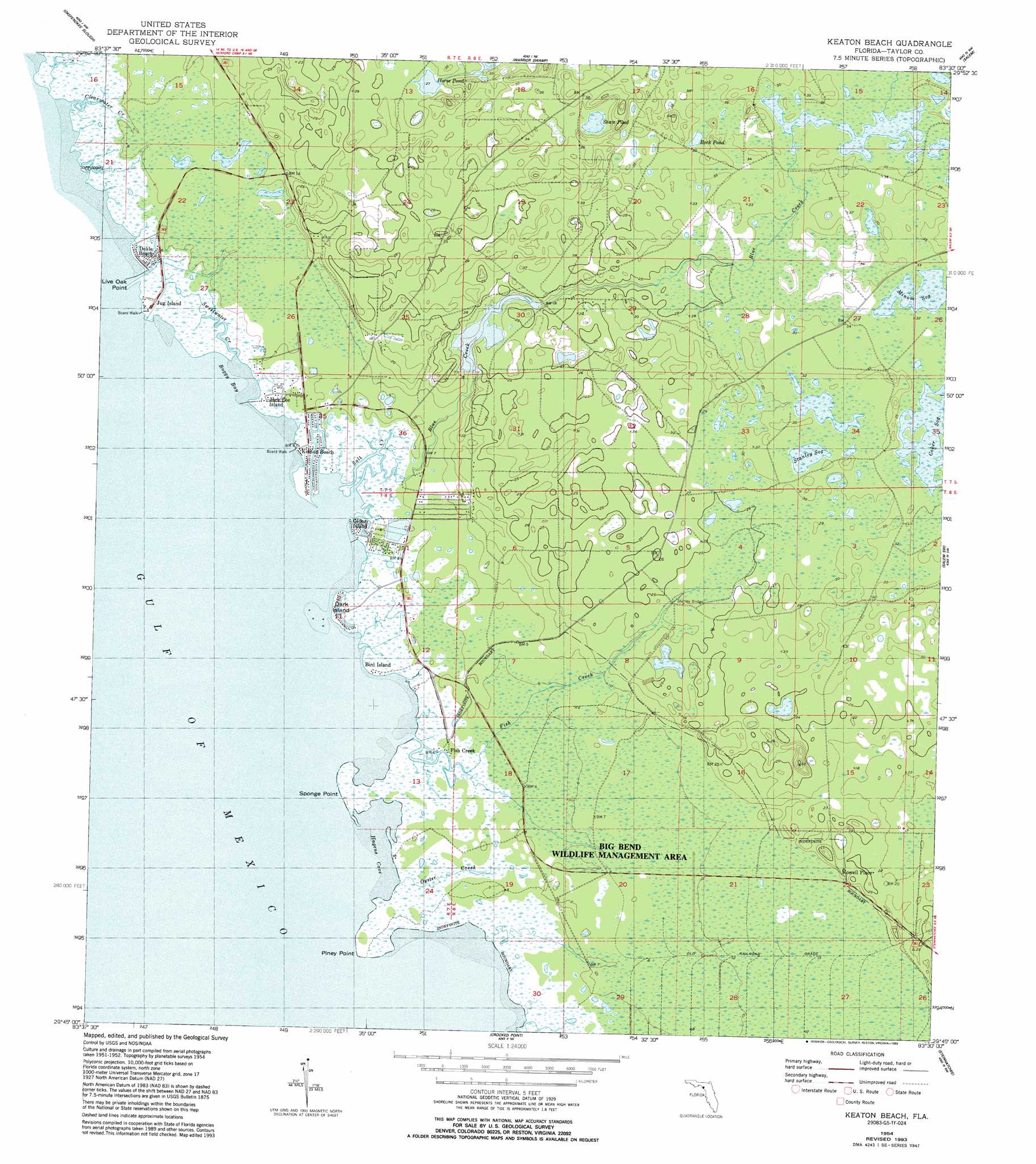
USGS Topo Quad 29083g5 - 1:24,000 scale
| Topo Map Name: | Keaton Beach |
| USGS Topo Quad ID: | 29083g5 |
| Print Size: | ca. 21 1/4" wide x 27" high |
| Southeast Coordinates: | 29.75° N latitude / 83.5° W longitude |
| Map Center Coordinates: | 29.8125° N latitude / 83.5625° W longitude |
| U.S. State: | FL |
| Filename: | O29083G5.jpg |
| Download Map JPG Image: | Keaton Beach topo map 1:24,000 scale |
| Map Type: | Topographic |
| Topo Series: | 7.5´ |
| Map Scale: | 1:24,000 |
| Source of Map Images: | United States Geological Survey (USGS) |
| Alternate Map Versions: |
Keaton Beach FL 1954, updated 1956 Download PDF Buy paper map Keaton Beach FL 1954, updated 1956 Download PDF Buy paper map Keaton Beach FL 1954, updated 1993 Download PDF Buy paper map Keaton Beach FL 2012 Download PDF Buy paper map Keaton Beach FL 2015 Download PDF Buy paper map |
1:24,000 Topo Quads surrounding Keaton Beach
Manlin Hammock |
Hampton Springs |
Perry |
Fenholloway |
Day Se |
Rock Islands |
Okefenokee Slough |
Warrior Swamp |
Salem |
Cooks Hammock |
Keaton Beach |
Salem Sw |
Clara |
||
Crooked Point |
Steinhatchee |
Jena |
||
Steinhatchee Sw |
Steinhatchee Se |
> Back to 29083e1 at 1:100,000 scale
> Back to 29082a1 at 1:250,000 scale
> Back to U.S. Topo Maps home
Keaton Beach topo map: Gazetteer
Keaton Beach: Airports
Sylvanmir Farms Airport elevation 3m 9′Keaton Beach: Bays
Boggy Bay elevation 0m 0′Hagens Cove elevation 0m 0′
Keaton Beach: Bridges
Stanley Bridge elevation 6m 19′Keaton Beach: Capes
Live Oak Point elevation 0m 0′Piney Point elevation 0m 0′
Sponge Point elevation 0m 0′
Keaton Beach: Islands
Dark Island elevation 0m 0′Keaton Beach: Lakes
Horse Pond elevation 8m 26′Rock Pond elevation 10m 32′
Shaw Pond elevation 10m 32′
Keaton Beach: Populated Places
Dekle Beach elevation 1m 3′Fish Creek elevation 1m 3′
Howell Place elevation 7m 22′
Keaton Beach elevation 0m 0′
Keaton Beach: Streams
Blue Creek elevation 1m 3′Fish Creek elevation 1m 3′
Oyster Creek elevation 1m 3′
Salt Creek elevation 0m 0′
Sweetwater Creek elevation 0m 0′
Keaton Beach: Swamps
Coker Sog elevation 10m 32′Minom Sog elevation 10m 32′
Stanley Sog elevation 10m 32′
Keaton Beach digital topo map on disk
Buy this Keaton Beach topo map showing relief, roads, GPS coordinates and other geographical features, as a high-resolution digital map file on DVD: