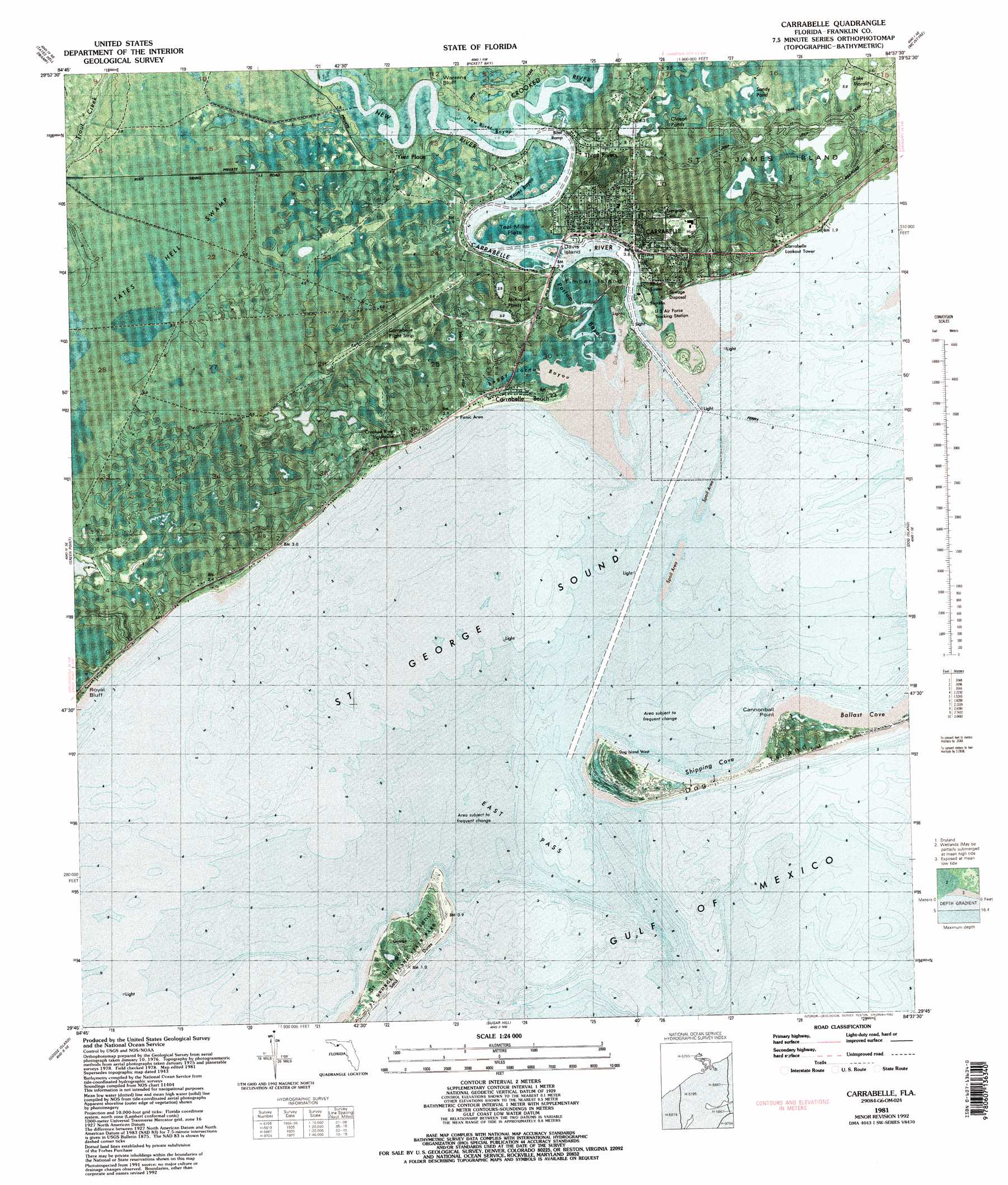
Carrabelle Topo Map Florida
To zoom in, hover over the map of Carrabelle
USGS Topo Quad 29084g6 - 1:24,000 scale
| Topo Map Name: | Carrabelle |
| USGS Topo Quad ID: | 29084g6 |
| Print Size: | ca. 21 1/4" wide x 27" high |
| Southeast Coordinates: | 29.75° N latitude / 84.625° W longitude |
| Map Center Coordinates: | 29.8125° N latitude / 84.6875° W longitude |
| U.S. State: | FL |
| Filename: | P29084g6.jpg |
| Download Map JPG Image: | Carrabelle topo map 1:24,000 scale |
| Map Type: | Orthophoto |
| Topo Series: | 7.5´ |
| Map Scale: | 1:24,000 |
| Source of Map Images: | United States Geological Survey (USGS) |
| Alternate Map Versions: |
Carrabelle FL 1943, updated 1968 Download PDF Buy paper map Carrabelle FL 1944, updated 1960 Download PDF Buy paper map Carrabelle FL 1981, updated 1982 Download PDF Buy paper map Carrabelle FL 1981, updated 1989 Download PDF Buy paper map Carrabelle FL 1981, updated 1992 Download PDF Buy paper map Carrabelle FL 1981, updated 1992 Download PDF Buy paper map Carrabelle FL 2012 Download PDF Buy paper map Carrabelle FL 2015 Download PDF Buy paper map |
1:24,000 Topo Quads surrounding Carrabelle
Sumatra |
Owens Bridge |
Thousand Yard Bay |
Sanborn |
Sopchoppy |
Fort Gadsden |
Tates Hell Swamp |
Pickett Bay |
Mcintyre |
Saint Teresa Beach |
Beverly |
Green Point |
Carrabelle |
Dog Island |
|
Apalachicola |
Goose Island |
Sugar Hill |
||
New Inlet |
> Back to 29084e1 at 1:100,000 scale
> Back to 29084a1 at 1:250,000 scale
> Back to U.S. Topo Maps home
Carrabelle topo map: Gazetteer
Carrabelle: Airports
Carrabelle-Thompson Airport elevation 4m 13′Carrabelle: Bays
Dickerman Cut elevation 0m 0′Kapes Bayou elevation 1m 3′
New River Bayou elevation 0m 0′
Saint George Sound elevation 0m 0′
Carrabelle: Bridges
Tillie Miller Bridge elevation 0m 0′Carrabelle: Channels
Charlie McKissack Cut elevation 0m 0′East Pass elevation 0m 0′
Carrabelle: Cliffs
Royal Bluff elevation 4m 13′Warrens Bluff elevation 1m 3′
Carrabelle: Flats
Teal Miller Flats elevation 1m 3′Carrabelle: Guts
Postun Bayou elevation 1m 3′Carrabelle: Harbors
Carrabelle Harbor elevation 0m 0′Carrabelle: Islands
Davis Island elevation 1m 3′Timber Island elevation 1m 3′
Carrabelle: Lakes
Chason Ponds elevation 4m 13′Lake Morality elevation 5m 16′
McKissack Ponds elevation 1m 3′
Sandy Pond elevation 5m 16′
Carrabelle: Populated Places
Carrabelle elevation 8m 26′Carrabelle Beach elevation 2m 6′
Carrabelle Lighthouse elevation 4m 13′
Yent Place elevation 2m 6′
Carrabelle: Streams
Boggy Jordan Bayou elevation 0m 0′Carrabelle River elevation 0m 0′
Crooked River elevation 1m 3′
New River elevation 1m 3′
Carrabelle: Swamps
Picketts Bay elevation 4m 13′Carrabelle digital topo map on disk
Buy this Carrabelle topo map showing relief, roads, GPS coordinates and other geographical features, as a high-resolution digital map file on DVD:
Gulf Coast (LA, MS, AL, FL) & Southwestern Georgia
Buy digital topo maps: Gulf Coast (LA, MS, AL, FL) & Southwestern Georgia
 & Southwestern Georgia map DVD")