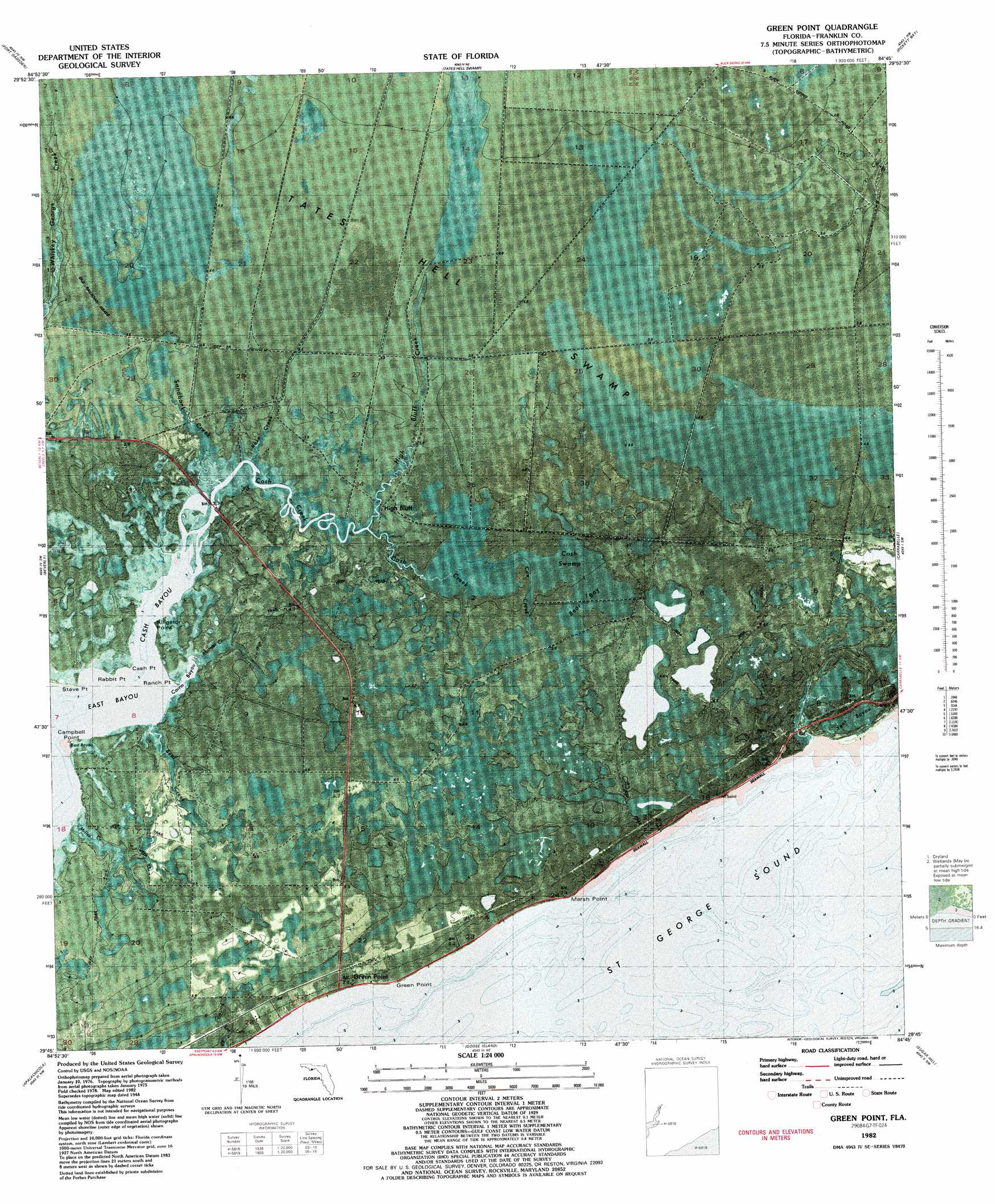
Green Point Topo Map Florida
To zoom in, hover over the map of Green Point
USGS Topo Quad 29084g7 - 1:24,000 scale
| Topo Map Name: | Green Point |
| USGS Topo Quad ID: | 29084g7 |
| Print Size: | ca. 21 1/4" wide x 27" high |
| Southeast Coordinates: | 29.75° N latitude / 84.75° W longitude |
| Map Center Coordinates: | 29.8125° N latitude / 84.8125° W longitude |
| U.S. State: | FL |
| Filename: | P29084g7.jpg |
| Download Map JPG Image: | Green Point topo map 1:24,000 scale |
| Map Type: | Orthophoto |
| Topo Series: | 7.5´ |
| Map Scale: | 1:24,000 |
| Source of Map Images: | United States Geological Survey (USGS) |
| Alternate Map Versions: |
Green Point FL 1944, updated 1960 Download PDF Buy paper map Green Point FL 1982, updated 1982 Download PDF Buy paper map Green Point FL 1982, updated 1989 Download PDF Buy paper map Green Point FL 2012 Download PDF Buy paper map Green Point FL 2015 Download PDF Buy paper map |
1:24,000 Topo Quads surrounding Green Point
Kennedy Creek |
Sumatra |
Owens Bridge |
Thousand Yard Bay |
Sanborn |
Forbes Island |
Fort Gadsden |
Tates Hell Swamp |
Pickett Bay |
Mcintyre |
Jackson River |
Beverly |
Green Point |
Carrabelle |
Dog Island |
West Pass |
Apalachicola |
Goose Island |
Sugar Hill |
|
Cape Saint George |
New Inlet |
> Back to 29084e1 at 1:100,000 scale
> Back to 29084a1 at 1:250,000 scale
> Back to U.S. Topo Maps home
Green Point topo map: Gazetteer
Green Point: Bays
Carrin Bayou elevation 0m 0′Cash Bayou elevation 1m 3′
East Bayou elevation 0m 0′
Green Point: Capes
Alligator Point elevation 0m 0′Campbell Point elevation 1m 3′
Cash Point elevation 0m 0′
Green Point elevation 0m 0′
Marsh Point elevation 1m 3′
Rabbit Point elevation 1m 3′
Ranch Point elevation 1m 3′
Stave Point elevation 1m 3′
Green Point: Guts
Yent Bayou elevation 1m 3′Green Point: Populated Places
Green Point elevation 2m 6′High Bluff elevation 1m 3′
Green Point: Streams
Bear Creek elevation 0m 0′Cash Creek elevation 1m 3′
Cow Creek elevation 1m 3′
High Bluff Creek elevation 1m 3′
Marian Creek elevation 1m 3′
Miller Creek elevation 1m 3′
Rake Creek elevation 1m 3′
Sandbank Creek elevation 1m 3′
Green Point: Swamps
Bear Bay elevation 2m 6′Bird Swamp elevation 4m 13′
Cash Swamp elevation 1m 3′
Otter Creek Swamp elevation 3m 9′
Green Point digital topo map on disk
Buy this Green Point topo map showing relief, roads, GPS coordinates and other geographical features, as a high-resolution digital map file on DVD:
Gulf Coast (LA, MS, AL, FL) & Southwestern Georgia
Buy digital topo maps: Gulf Coast (LA, MS, AL, FL) & Southwestern Georgia
 & Southwestern Georgia map DVD")