Forbes Island Topo Map Florida
To zoom in, hover over the map of Forbes Island
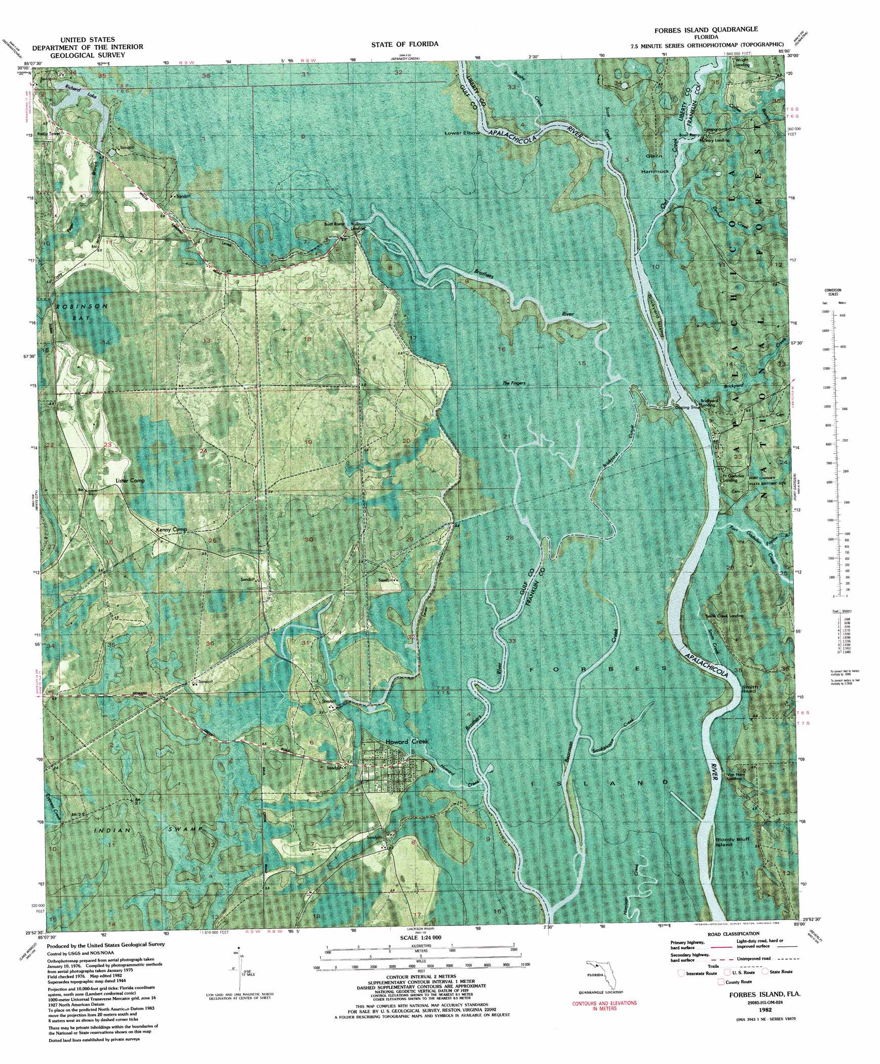
USGS Topo Quad 29085h1 - 1:24,000 scale
| Topo Map Name: | Forbes Island |
| USGS Topo Quad ID: | 29085h1 |
| Print Size: | ca. 21 1/4" wide x 27" high |
| Southeast Coordinates: | 29.875° N latitude / 85° W longitude |
| Map Center Coordinates: | 29.9375° N latitude / 85.0625° W longitude |
| U.S. State: | FL |
| Filename: | P29085H1.jpg |
| Download Map JPG Image: | Forbes Island topo map 1:24,000 scale |
| Map Type: | Orthophoto |
| Topo Series: | 7.5´ |
| Map Scale: | 1:24,000 |
| Source of Map Images: | United States Geological Survey (USGS) |
| Alternate Map Versions: |
Forbes Island FL 1944, updated 1960 Download PDF Buy paper map Forbes Island FL 1944, updated 1960 Download PDF Buy paper map Forbes Island FL 1982, updated 1984 Download PDF Buy paper map Forbes Island FL 2012 Download PDF Buy paper map Forbes Island FL 2015 Download PDF Buy paper map |
| FStopo: | US Forest Service topo Forbes Island is available: Download FStopo PDF Download FStopo TIF |
1:24,000 Topo Quads surrounding Forbes Island
Tenmile Swamp |
Dead Lake |
Orange |
Wilma |
Queens Bay |
Wetappo Creek |
Wewahitchka |
Kennedy Creek |
Sumatra |
Owens Bridge |
Overstreet |
White City |
Forbes Island |
Fort Gadsden |
Tates Hell Swamp |
Port Saint Joe |
Lake Wimico |
Jackson River |
Beverly |
Green Point |
Cape San Blas |
Indian Pass |
West Pass |
Apalachicola |
Goose Island |
> Back to 29085e1 at 1:100,000 scale
> Back to 29084a1 at 1:250,000 scale
> Back to U.S. Topo Maps home
Forbes Island topo map: Gazetteer
Forbes Island: Guts
Brickyard Cut Off elevation 1m 3′Forbes Island: Islands
Bloody Bluff Island elevation 1m 3′Downes Island elevation 2m 6′
Forbes Island elevation 1m 3′
Glenn Hammock elevation 2m 6′
Forbes Island: Parks
Fort Gadsden State Historic Site elevation 3m 9′Fort Gadsden State Park elevation 4m 13′
Forbes Island: Populated Places
Brickyard elevation 2m 6′Ekanachatte (historical) elevation 3m 9′
Forbes Island: Streams
Bearman Creek elevation 0m 0′Brickyard Creek elevation 1m 3′
Brushy Creek elevation 1m 3′
Devon Creek elevation 2m 6′
Fort Gadsden Creek elevation 1m 3′
Howard Creek elevation 0m 0′
Owl Creek elevation 1m 3′
Poplar Branch elevation 1m 3′
Smokehouse Creek elevation 1m 3′
Forbes Island: Swamps
Robinson Bay elevation 3m 9′Van Horn Bay elevation 3m 9′
Forbes Island digital topo map on disk
Buy this Forbes Island topo map showing relief, roads, GPS coordinates and other geographical features, as a high-resolution digital map file on DVD:
Gulf Coast (LA, MS, AL, FL) & Southwestern Georgia
Buy digital topo maps: Gulf Coast (LA, MS, AL, FL) & Southwestern Georgia
 & Southwestern Georgia map DVD")