Garden Island Pass Topo Map Louisiana
To zoom in, hover over the map of Garden Island Pass
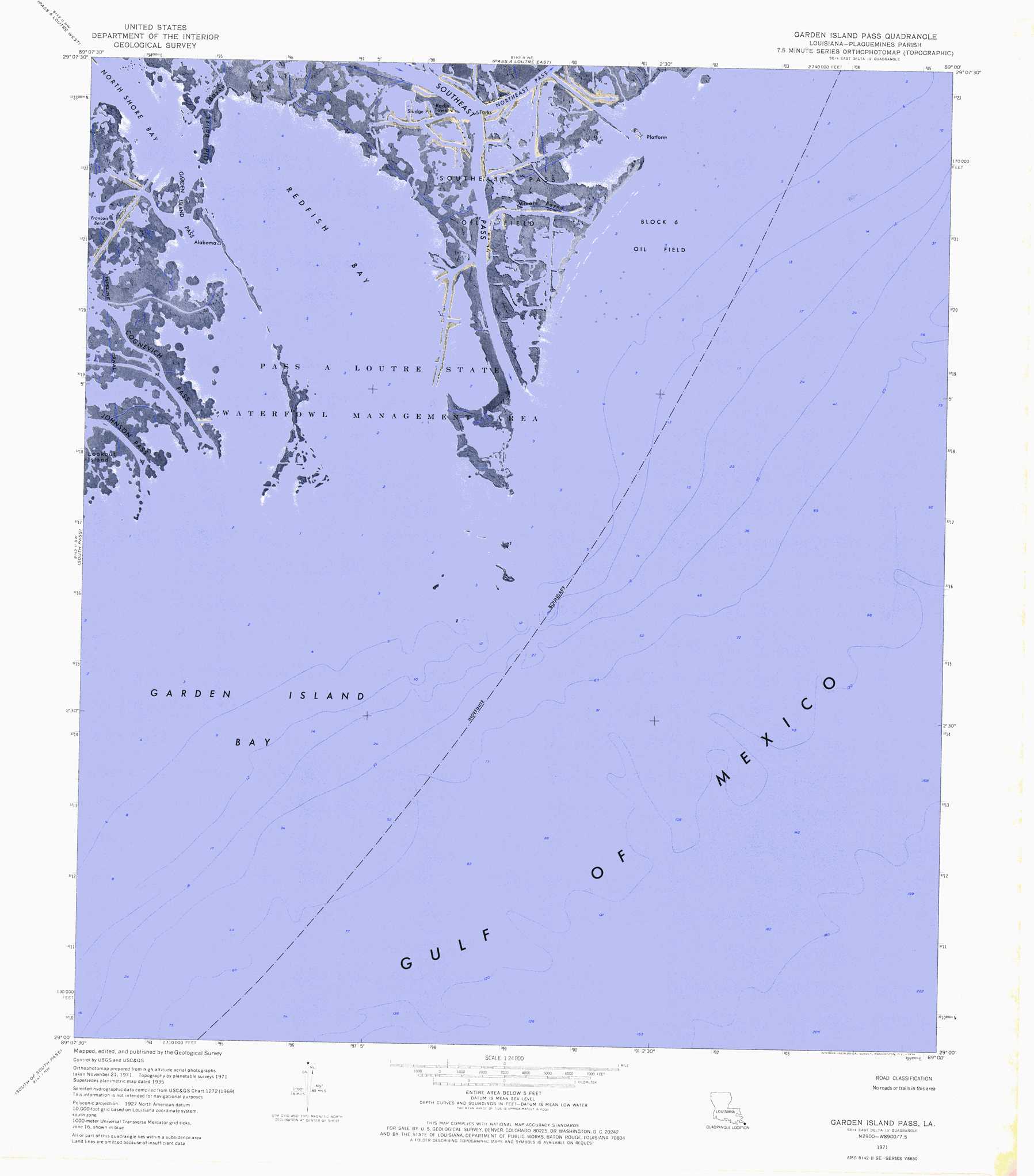
USGS Topo Quad 29089a1 - 1:24,000 scale
| Topo Map Name: | Garden Island Pass |
| USGS Topo Quad ID: | 29089a1 |
| Print Size: | ca. 21 1/4" wide x 27" high |
| Southeast Coordinates: | 29° N latitude / 89° W longitude |
| Map Center Coordinates: | 29.0625° N latitude / 89.0625° W longitude |
| U.S. State: | LA |
| Filename: | p29089a1.jpg |
| Download Map JPG Image: | Garden Island Pass topo map 1:24,000 scale |
| Map Type: | Orthophoto |
| Topo Series: | 7.5´ |
| Map Scale: | 1:24,000 |
| Source of Map Images: | United States Geological Survey (USGS) |
| Alternate Map Versions: |
Garden Island Pass LA 1971, updated 1974 Download PDF Buy paper map Garden Island Pass LA 2012 Download PDF Buy paper map Garden Island Pass LA 2015 Download PDF Buy paper map |
1:24,000 Topo Quads surrounding Garden Island Pass
Venice |
Main Pass |
Breton Islands Se |
||
Pilottown |
Pass A Loutre West |
Pass A Loutre East |
||
Dixon Bay |
South Pass |
Garden Island Pass |
||
Burrwood Bayou East |
South Of South Pass |
|||
> Back to 29089a1 at 1:100,000 scale
> Back to 29088a1 at 1:250,000 scale
> Back to U.S. Topo Maps home
Garden Island Pass topo map: Gazetteer
Garden Island Pass: Bays
Garden Island Bay elevation 0m 0′North Shore Bay elevation 0m 0′
Redfish Bay elevation 0m 0′
Garden Island Pass: Channels
Bayou Ronquille (historical) elevation 0m 0′Buttermilk Channel (historical) elevation 0m 0′
Garden Island Pass elevation 0m 0′
Mississippi Bayou elevation 0m 0′
Redfish Bayou (historical) elevation 0m 0′
Second Bayou elevation 0m 0′
Garden Island Pass: Guts
Micale Bayou elevation 0m 0′Old Balize Bayou elevation 0m 0′
Garden Island Pass: Islands
Garden Island Bay elevation 0m 0′Garden Island Pass: Oilfields
Block 6 Oil Field elevation 0m 0′Southeast Pass Oil Field elevation 4m 13′
Garden Island Pass: Populated Places
Balize (historical) elevation 0m 0′Garden Island Pass digital topo map on disk
Buy this Garden Island Pass topo map showing relief, roads, GPS coordinates and other geographical features, as a high-resolution digital map file on DVD:
Gulf Coast (LA, MS, AL, FL) & Southwestern Georgia
Buy digital topo maps: Gulf Coast (LA, MS, AL, FL) & Southwestern Georgia
 & Southwestern Georgia map DVD")