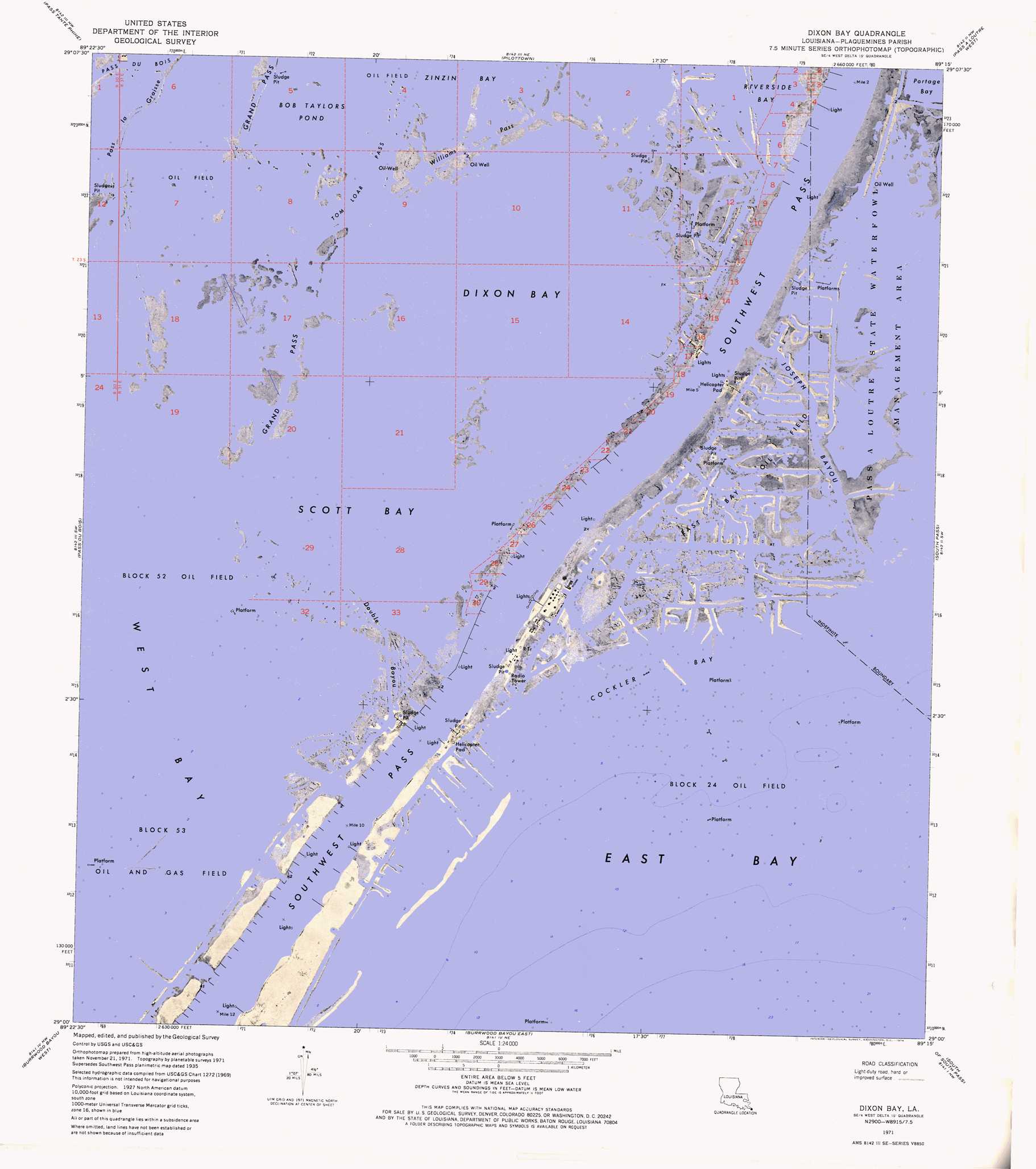
Dixon Bay Topo Map Louisiana
To zoom in, hover over the map of Dixon Bay
USGS Topo Quad 29089a3 - 1:24,000 scale
| Topo Map Name: | Dixon Bay |
| USGS Topo Quad ID: | 29089a3 |
| Print Size: | ca. 21 1/4" wide x 27" high |
| Southeast Coordinates: | 29° N latitude / 89.25° W longitude |
| Map Center Coordinates: | 29.0625° N latitude / 89.3125° W longitude |
| U.S. State: | LA |
| Filename: | p29089a3.jpg |
| Download Map JPG Image: | Dixon Bay topo map 1:24,000 scale |
| Map Type: | Orthophoto |
| Topo Series: | 7.5´ |
| Map Scale: | 1:24,000 |
| Source of Map Images: | United States Geological Survey (USGS) |
| Alternate Map Versions: |
Dixon Bay LA 1971, updated 1974 Download PDF Buy paper map Dixon Bay LA 1971, updated 1974 Download PDF Buy paper map Dixon Bay LA 1998, updated 2002 Download PDF Buy paper map Dixon Bay LA 2012 Download PDF Buy paper map Dixon Bay LA 2015 Download PDF Buy paper map |
1:24,000 Topo Quads surrounding Dixon Bay
Buras |
Triumph |
Venice |
Main Pass |
Breton Islands Se |
Bay Coquette |
Pass Tante Phine |
Pilottown |
Pass A Loutre West |
Pass A Loutre East |
Pass Du Bois |
Dixon Bay |
South Pass |
Garden Island Pass |
|
Burrwood Bayou West |
Burrwood Bayou East |
South Of South Pass |
||
> Back to 29089a1 at 1:100,000 scale
> Back to 29088a1 at 1:250,000 scale
> Back to U.S. Topo Maps home
Dixon Bay topo map: Gazetteer
Dixon Bay: Airports
Chevron Southpass Tank Battery W-2 Heliport elevation 0m 0′E-3 Tank Battery Seaplane Base elevation 0m 0′
Shell Central Facilities East Bay Block 24 Heliport elevation 0m 0′
Shell Central Facilities Seaplane Base elevation 5m 16′
W-1 Tank Battery Seaplane Base elevation 0m 0′
W-2 Tank Battery Seaplane Base elevation 0m 0′
Dixon Bay: Bays
Bay Macoin elevation 0m 0′Bay Ronfleur elevation 0m 0′
Bay Saint Honore elevation 0m 0′
Bob Taylors Pond elevation 0m 0′
Cockler Bay elevation 4m 13′
Dixon Bay elevation 0m 0′
East Bay elevation 0m 0′
Porpoise Bay elevation 0m 0′
Scott Bay elevation 0m 0′
Dixon Bay: Capes
Cockler Point elevation -1m -4′Cockler Point elevation 0m 0′
Dixon Bay: Channels
Caminada Pass elevation 0m 0′Outlet E-1 elevation 0m 0′
Outlet E-2 elevation 0m 0′
Outlet E-3 elevation 0m 0′
Outlet W-1 elevation -2m -7′
Outlet W-2 elevation 0m 0′
Southwest Pass elevation 0m 0′
Dixon Bay: Guts
Bayou Fort Blanc elevation 0m 0′Bayou Saint Honore elevation 0m 0′
Bayou Thunder Von Tranc elevation 0m 0′
Customhouse Bayou (historical) elevation 0m 0′
Double Bayou elevation 0m 0′
Joseph Bayou elevation 0m 0′
Pass La Graisse elevation 0m 0′
Williams Pass elevation 0m 0′
Dixon Bay: Oilfields
Block 24 Oil Field elevation 0m 0′Block 52 Oil Field elevation 0m 0′
Block 53 Oil and Gas Field elevation 0m 0′
East Bay Oil Field elevation 0m 0′
Dixon Bay digital topo map on disk
Buy this Dixon Bay topo map showing relief, roads, GPS coordinates and other geographical features, as a high-resolution digital map file on DVD:
Gulf Coast (LA, MS, AL, FL) & Southwestern Georgia
Buy digital topo maps: Gulf Coast (LA, MS, AL, FL) & Southwestern Georgia
 & Southwestern Georgia map DVD")