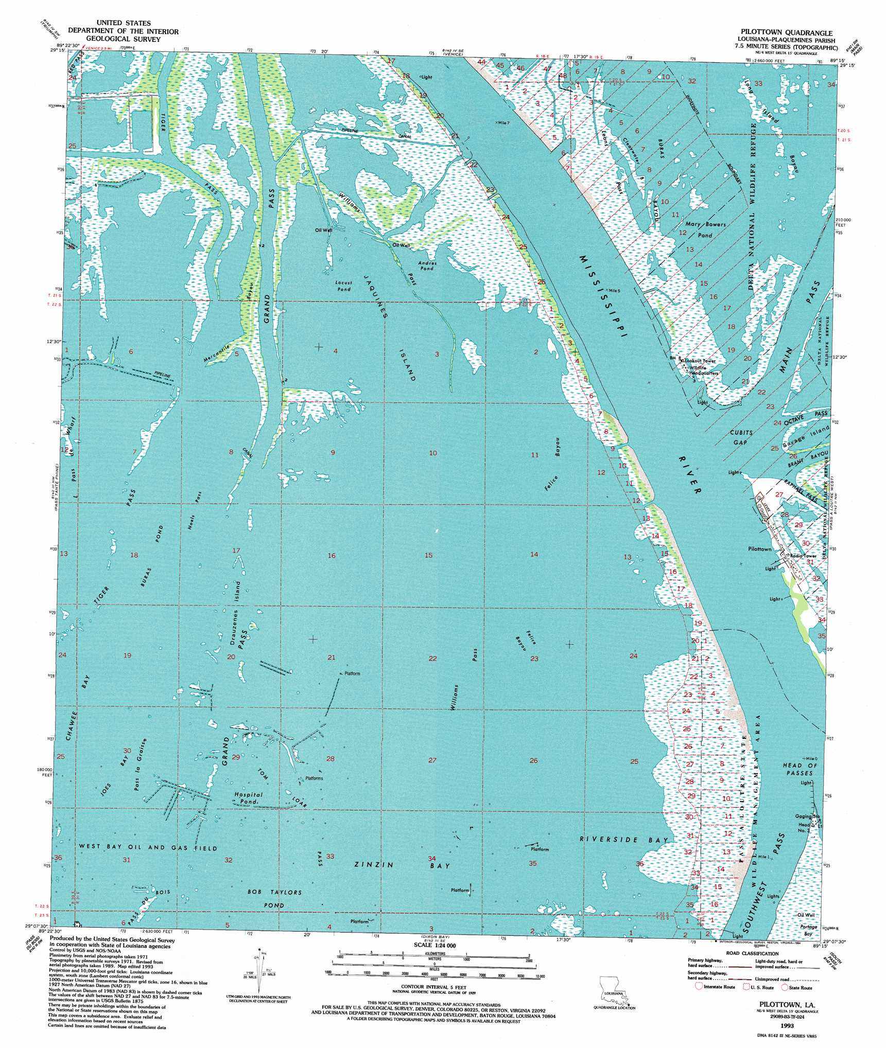
Pilottown Topo Map Louisiana
To zoom in, hover over the map of Pilottown
USGS Topo Quad 29089b3 - 1:24,000 scale
| Topo Map Name: | Pilottown |
| USGS Topo Quad ID: | 29089b3 |
| Print Size: | ca. 21 1/4" wide x 27" high |
| Southeast Coordinates: | 29.125° N latitude / 89.25° W longitude |
| Map Center Coordinates: | 29.1875° N latitude / 89.3125° W longitude |
| U.S. State: | LA |
| Filename: | o29089b3.jpg |
| Download Map JPG Image: | Pilottown topo map 1:24,000 scale |
| Map Type: | Topographic |
| Topo Series: | 7.5´ |
| Map Scale: | 1:24,000 |
| Source of Map Images: | United States Geological Survey (USGS) |
| Alternate Map Versions: |
Pilottown LA 1971, updated 1974 Download PDF Buy paper map Pilottown LA 1971, updated 1984 Download PDF Buy paper map Pilottown LA 1993, updated 1993 Download PDF Buy paper map Pilottown LA 1993, updated 1994 Download PDF Buy paper map Pilottown LA 2012 Download PDF Buy paper map Pilottown LA 2015 Download PDF Buy paper map |
1:24,000 Topo Quads surrounding Pilottown
Empire |
Coquille Point |
Taylor Pass |
Breton Islands |
|
Buras |
Triumph |
Venice |
Main Pass |
Breton Islands Se |
Bay Coquette |
Pass Tante Phine |
Pilottown |
Pass A Loutre West |
Pass A Loutre East |
Pass Du Bois |
Dixon Bay |
South Pass |
Garden Island Pass |
|
Burrwood Bayou West |
Burrwood Bayou East |
South Of South Pass |
> Back to 29089a1 at 1:100,000 scale
> Back to 29088a1 at 1:250,000 scale
> Back to U.S. Topo Maps home
Pilottown topo map: Gazetteer
Pilottown: Areas
Mississippi River Delta elevation 1m 3′Pilottown: Bays
Andres Pond elevation 0m 0′Bay Chalon elevation 0m 0′
Bottle Pond elevation 0m 0′
Buras Pond elevation 0m 0′
Chawee Bay elevation 0m 0′
Hospital Pond elevation 1m 3′
Joes Bay elevation 0m 0′
Locust Pond elevation 0m 0′
Mary Bowers Pond elevation 0m 0′
Portage Bay elevation 0m 0′
Riverside Bay elevation 0m 0′
Te Don Pond elevation 0m 0′
Twin Lakes elevation 0m 0′
Zinzin Bay elevation 0m 0′
Pilottown: Canals
Cooks Canal (historical) elevation 0m 0′Pilottown: Channels
Felice Bayou elevation 0m 0′Grand Pass elevation 2m 6′
Jaquines Pass (historical) elevation 0m 0′
Sullivan Bayou (historical) elevation 0m 0′
Tiger Pass elevation 0m 0′
Tom Loar Pass elevation 0m 0′
Pilottown: Gaps
Cubits Gap elevation 1m 3′Head of Passes elevation 1m 3′
Pilottown: Guts
Clearwater Bayou elevation 1m 3′Drauzenes Island elevation 0m 0′
Felice Bayou elevation 0m 0′
Leons Pass elevation 1m 3′
Little Pass de Wharf elevation 0m 0′
Long Island Bayou elevation 0m 0′
Mercantile Bayou elevation 1m 3′
Noels Pass elevation 0m 0′
Oil Mine Bayou (historical) elevation 0m 0′
Pass La Graisse elevation 0m 0′
Williams Pass elevation 0m 0′
Williams Pass elevation 0m 0′
Pilottown: Islands
Jaquines Island elevation 0m 0′Savage Island elevation 1m 3′
Pilottown: Populated Places
Pilottown elevation 1m 3′Pilottown: Post Offices
Pilottown Post Office elevation 1m 3′Pilottown: Streams
Mississippi River elevation 1m 3′Pilottown digital topo map on disk
Buy this Pilottown topo map showing relief, roads, GPS coordinates and other geographical features, as a high-resolution digital map file on DVD:
Gulf Coast (LA, MS, AL, FL) & Southwestern Georgia
Buy digital topo maps: Gulf Coast (LA, MS, AL, FL) & Southwestern Georgia
 & Southwestern Georgia map DVD")