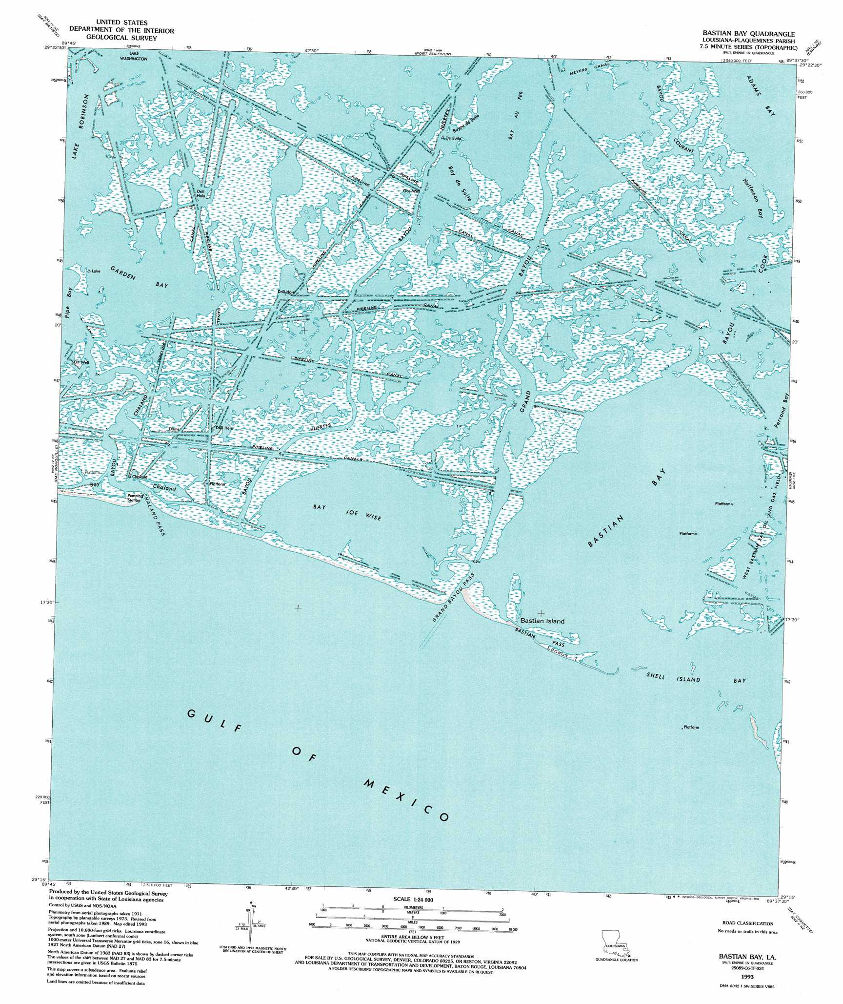
Bastian Bay Topo Map Louisiana
To zoom in, hover over the map of Bastian Bay
USGS Topo Quad 29089c6 - 1:24,000 scale
| Topo Map Name: | Bastian Bay |
| USGS Topo Quad ID: | 29089c6 |
| Print Size: | ca. 21 1/4" wide x 27" high |
| Southeast Coordinates: | 29.25° N latitude / 89.625° W longitude |
| Map Center Coordinates: | 29.3125° N latitude / 89.6875° W longitude |
| U.S. State: | LA |
| Filename: | o29089c6.jpg |
| Download Map JPG Image: | Bastian Bay topo map 1:24,000 scale |
| Map Type: | Topographic |
| Topo Series: | 7.5´ |
| Map Scale: | 1:24,000 |
| Source of Map Images: | United States Geological Survey (USGS) |
| Alternate Map Versions: |
Bastian Bay LA 1973, updated 1976 Download PDF Buy paper map Bastian Bay LA 1973, updated 1989 Download PDF Buy paper map Bastian Bay LA 1993, updated 1995 Download PDF Buy paper map Bastian Bay LA 2012 Download PDF Buy paper map Bastian Bay LA 2015 Download PDF Buy paper map |
1:24,000 Topo Quads surrounding Bastian Bay
Lake Laurier |
Pointe A La Hache |
Happy Jack |
Black Bay South |
|
Wilkinson Bay |
Bay Batiste |
Port Sulphur |
Empire |
Coquille Point |
Barataria Pass |
Bay Ronquille |
Bastian Bay |
Buras |
Triumph |
Grand Isle |
Bay Coquette |
Pass Tante Phine |
||
Pass Du Bois |
> Back to 29089a1 at 1:100,000 scale
> Back to 29088a1 at 1:250,000 scale
> Back to U.S. Topo Maps home
Bastian Bay topo map: Gazetteer
Bastian Bay: Bays
Bastian Bay elevation 0m 0′Bay Chaland elevation 0m 0′
Ferrand Bay elevation 0m 0′
Garden Bay elevation 0m 0′
Lake Robinson elevation 0m 0′
Shell Island Bay elevation 0m 0′
Bastian Bay: Channels
Bastian Pass elevation 0m 0′Chaland Pass elevation 1m 3′
Grand Bayou Pass elevation 1m 3′
Bastian Bay: Guts
Bayou Chaland elevation 0m 0′Bayou Cook elevation 0m 0′
Bayou Courant elevation 0m 0′
Bayou de Suite elevation 0m 0′
Bayou Huertes elevation 0m 0′
Bastian Bay: Islands
Bastian Island elevation 0m 0′Lanaux Island elevation 0m 0′
Bastian Bay: Lakes
Bay Au Fer elevation 0m 0′Bay de Suite elevation 0m 0′
Bay Joe Wise elevation 0m 0′
Halfmoon Bay elevation 0m 0′
Bastian Bay digital topo map on disk
Buy this Bastian Bay topo map showing relief, roads, GPS coordinates and other geographical features, as a high-resolution digital map file on DVD:
Gulf Coast (LA, MS, AL, FL) & Southwestern Georgia
Buy digital topo maps: Gulf Coast (LA, MS, AL, FL) & Southwestern Georgia
 & Southwestern Georgia map DVD")