Bay Batiste Topo Map Louisiana
To zoom in, hover over the map of Bay Batiste
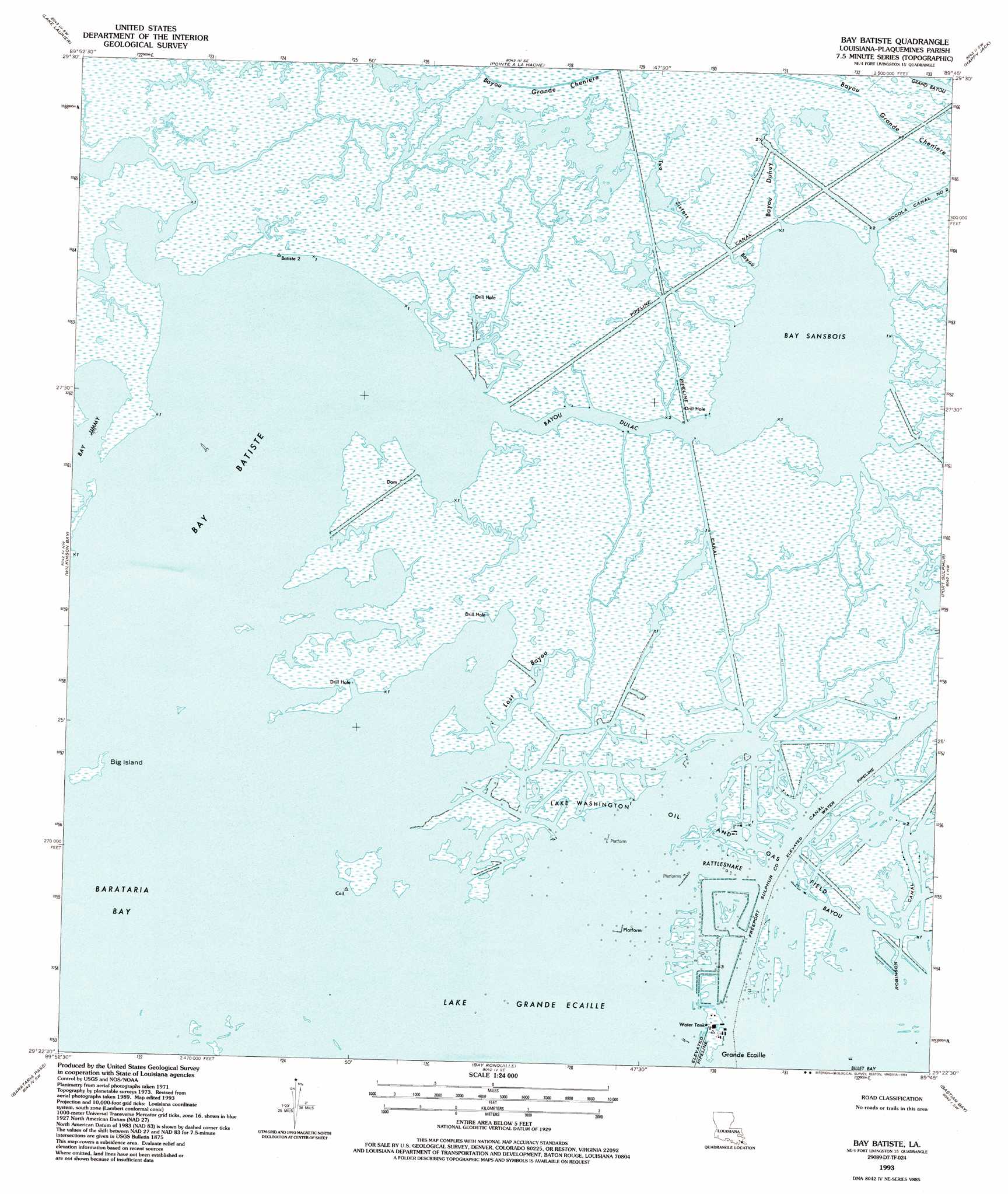
USGS Topo Quad 29089d7 - 1:24,000 scale
| Topo Map Name: | Bay Batiste |
| USGS Topo Quad ID: | 29089d7 |
| Print Size: | ca. 21 1/4" wide x 27" high |
| Southeast Coordinates: | 29.375° N latitude / 89.75° W longitude |
| Map Center Coordinates: | 29.4375° N latitude / 89.8125° W longitude |
| U.S. State: | LA |
| Filename: | o29089d7.jpg |
| Download Map JPG Image: | Bay Batiste topo map 1:24,000 scale |
| Map Type: | Topographic |
| Topo Series: | 7.5´ |
| Map Scale: | 1:24,000 |
| Source of Map Images: | United States Geological Survey (USGS) |
| Alternate Map Versions: |
Bay Batiste LA 1973, updated 1976 Download PDF Buy paper map Bay Batiste LA 1993, updated 1994 Download PDF Buy paper map Bay Batiste LA 2012 Download PDF Buy paper map Bay Batiste LA 2015 Download PDF Buy paper map |
1:24,000 Topo Quads surrounding Bay Batiste
Lafitte |
Phoenix |
Lake Batola |
Lake Cuatro Caballo |
Black Bay North |
Three Bayou Bay |
Lake Laurier |
Pointe A La Hache |
Happy Jack |
Black Bay South |
Bay Dosgris |
Wilkinson Bay |
Bay Batiste |
Port Sulphur |
Empire |
Bay Tambour |
Barataria Pass |
Bay Ronquille |
Bastian Bay |
Buras |
Caminada Pass |
Grand Isle |
Bay Coquette |
> Back to 29089a1 at 1:100,000 scale
> Back to 29088a1 at 1:250,000 scale
> Back to U.S. Topo Maps home
Bay Batiste topo map: Gazetteer
Bay Batiste: Bays
Bay Batiste elevation 0m 0′Lake Grand Ecaille elevation 0m 0′
Bay Batiste: Guts
Bayou Duhuy elevation 1m 3′Bayou Dulac elevation 0m 0′
Lost Bayou elevation 0m 0′
Rattlesnake Bayou elevation 0m 0′
Two Sisters Bayou elevation 0m 0′
Bay Batiste: Islands
Big Island elevation 0m 0′Bay Batiste: Lakes
Bay Sansbois elevation 0m 0′Bay Batiste: Oilfields
Lake Washington Oil and Gas Field elevation 1m 3′Bay Batiste: Populated Places
Grande Ecaille elevation 1m 3′Bay Batiste digital topo map on disk
Buy this Bay Batiste topo map showing relief, roads, GPS coordinates and other geographical features, as a high-resolution digital map file on DVD:
Gulf Coast (LA, MS, AL, FL) & Southwestern Georgia
Buy digital topo maps: Gulf Coast (LA, MS, AL, FL) & Southwestern Georgia
 & Southwestern Georgia map DVD")