Lake Cuatro Caballo Topo Map Louisiana
To zoom in, hover over the map of Lake Cuatro Caballo
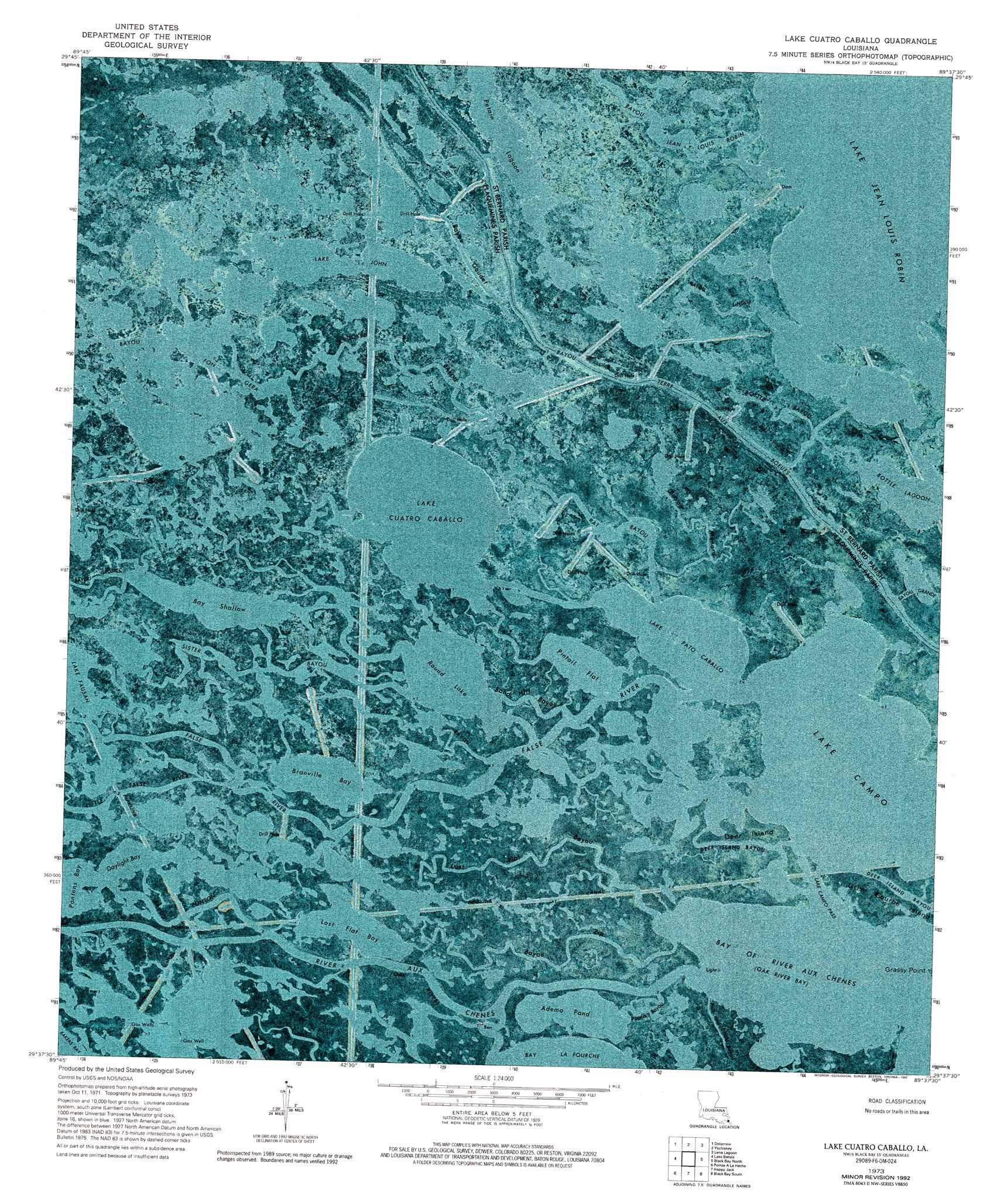
USGS Topo Quad 29089f6 - 1:24,000 scale
| Topo Map Name: | Lake Cuatro Caballo |
| USGS Topo Quad ID: | 29089f6 |
| Print Size: | ca. 21 1/4" wide x 27" high |
| Southeast Coordinates: | 29.625° N latitude / 89.625° W longitude |
| Map Center Coordinates: | 29.6875° N latitude / 89.6875° W longitude |
| U.S. State: | LA |
| Filename: | p29089f6.jpg |
| Download Map JPG Image: | Lake Cuatro Caballo topo map 1:24,000 scale |
| Map Type: | Orthophoto |
| Topo Series: | 7.5´ |
| Map Scale: | 1:24,000 |
| Source of Map Images: | United States Geological Survey (USGS) |
| Alternate Map Versions: |
Lake Cuatro Caballo LA 1973, updated 1976 Download PDF Buy paper map Lake Cuatro Caballo LA 1973, updated 1992 Download PDF Buy paper map Lake Cuatro Caballo LA 2012 Download PDF Buy paper map Lake Cuatro Caballo LA 2015 Download PDF Buy paper map |
1:24,000 Topo Quads surrounding Lake Cuatro Caballo
Chalmette |
Martello Castle |
Proctor Point |
Pte Aux Marchettes |
Lake Eugenie |
Belle Chasse |
Delacroix |
Yscloskey |
Lena Lagoon |
Lake Eloi |
Phoenix |
Lake Batola |
Lake Cuatro Caballo |
Black Bay North |
Lake Athanasio |
Lake Laurier |
Pointe A La Hache |
Happy Jack |
Black Bay South |
|
Wilkinson Bay |
Bay Batiste |
Port Sulphur |
Empire |
Coquille Point |
> Back to 29089e1 at 1:100,000 scale
> Back to 29088a1 at 1:250,000 scale
> Back to U.S. Topo Maps home
Lake Cuatro Caballo topo map: Gazetteer
Lake Cuatro Caballo: Bays
Bay of River Aux Chenes elevation 0m 0′Lake Cuatro Caballo: Channels
Lake Campo Pass elevation 0m 0′Lake Cuatro Caballo: Guts
Bayou Fon Gera elevation 0m 0′Bayou Goudet elevation 0m 0′
Bayou Grosbec elevation 0m 0′
Bayou Jean Louis Robin elevation 0m 0′
Bayou Lingeo elevation 0m 0′
Bayou Menard elevation 0m 0′
Bayou Ponton elevation 0m 0′
Bayou Zip elevation 0m 0′
Bottle Bayou elevation 0m 0′
Crooked Bayou elevation 0m 0′
Deer Island Bayou elevation 0m 0′
False River elevation 0m 0′
Flat Bayou elevation 0m 0′
Little False River elevation 0m 0′
Lost Flat Bayou elevation 0m 0′
Polk and Dallas Bayou elevation 0m 0′
Popcorn Bayou elevation 0m 0′
Rat Bayou elevation 0m 0′
River aux Chenes elevation 3m 9′
Sand Hill Bayou elevation 0m 0′
Sister Bayou elevation 0m 0′
Lake Cuatro Caballo: Islands
Deer Island elevation 0m 0′Lake Cuatro Caballo: Lakes
Adema Pond elevation 0m 0′Bay Shallow elevation 0m 0′
Bottle Lagoon elevation 0m 0′
Branville Bay elevation 0m 0′
Daylight Bay elevation 0m 0′
Lake Campo elevation 0m 0′
Lake Cuatro Caballo elevation 0m 0′
Lake Jean Louis Robin elevation 0m 0′
Lake John elevation 0m 0′
Lake Pato Caballo elevation 0m 0′
Lost Flat Bay elevation 0m 0′
Petain Lagoon elevation 0m 0′
Pintail Flat elevation 0m 0′
Round Lake elevation 0m 0′
Lake Cuatro Caballo: Oilfields
Crooked Bayou Gas Field elevation 0m 0′Lake Cuatro Caballo digital topo map on disk
Buy this Lake Cuatro Caballo topo map showing relief, roads, GPS coordinates and other geographical features, as a high-resolution digital map file on DVD:
Gulf Coast (LA, MS, AL, FL) & Southwestern Georgia
Buy digital topo maps: Gulf Coast (LA, MS, AL, FL) & Southwestern Georgia
 & Southwestern Georgia map DVD")