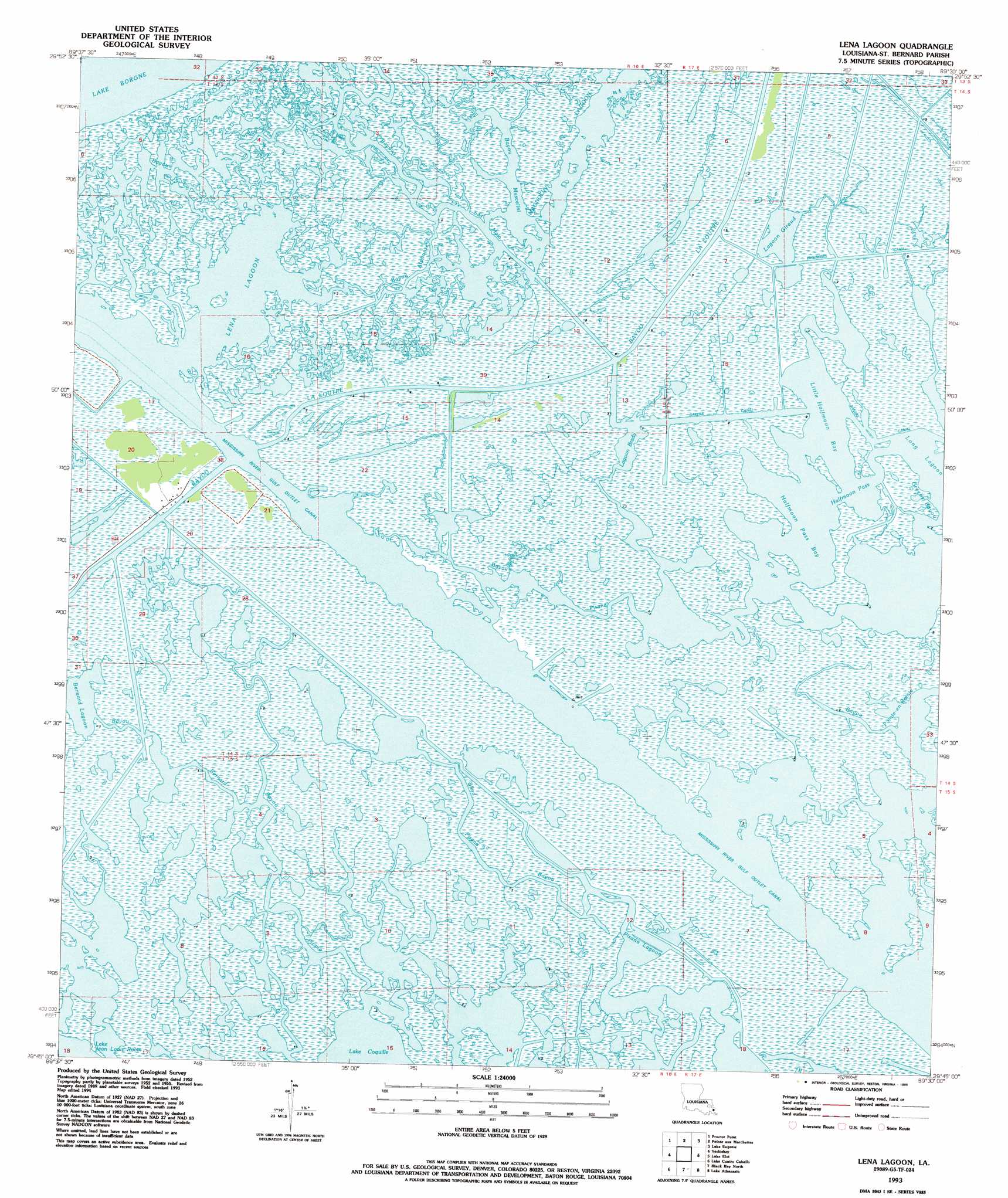
Lena Lagoon Topo Map Louisiana
To zoom in, hover over the map of Lena Lagoon
USGS Topo Quad 29089g5 - 1:24,000 scale
| Topo Map Name: | Lena Lagoon |
| USGS Topo Quad ID: | 29089g5 |
| Print Size: | ca. 21 1/4" wide x 27" high |
| Southeast Coordinates: | 29.75° N latitude / 89.5° W longitude |
| Map Center Coordinates: | 29.8125° N latitude / 89.5625° W longitude |
| U.S. State: | LA |
| Filename: | o29089g5.jpg |
| Download Map JPG Image: | Lena Lagoon topo map 1:24,000 scale |
| Map Type: | Topographic |
| Topo Series: | 7.5´ |
| Map Scale: | 1:24,000 |
| Source of Map Images: | United States Geological Survey (USGS) |
| Alternate Map Versions: |
Lena Lagoon LA 1955, updated 1959 Download PDF Buy paper map Lena Lagoon LA 1955, updated 1963 Download PDF Buy paper map Lena Lagoon LA 1968, updated 1969 Download PDF Buy paper map Lena Lagoon LA 1968, updated 1978 Download PDF Buy paper map Lena Lagoon LA 1993, updated 1995 Download PDF Buy paper map Lena Lagoon LA 2012 Download PDF Buy paper map Lena Lagoon LA 2015 Download PDF Buy paper map |
1:24,000 Topo Quads surrounding Lena Lagoon
Chef Menteur |
Alligator Point |
False Mouth Bayou |
Malheureux Point |
Three Mile Bay |
Martello Castle |
Proctor Point |
Pte Aux Marchettes |
Lake Eugenie |
Oak Mound Bayou |
Delacroix |
Yscloskey |
Lena Lagoon |
Lake Eloi |
Morgan Harbor |
Lake Batola |
Lake Cuatro Caballo |
Black Bay North |
Lake Athanasio |
Point Chicot |
Pointe A La Hache |
Happy Jack |
Black Bay South |
> Back to 29089e1 at 1:100,000 scale
> Back to 29088a1 at 1:250,000 scale
> Back to U.S. Topo Maps home
Lena Lagoon topo map: Gazetteer
Lena Lagoon: Canals
Bakers Canal elevation 1m 3′Engineers Canal elevation 1m 3′
Jahnckes Ditch elevation 0m 0′
Lena Lagoon: Guts
Bayou Alphonse elevation 0m 0′Bayou Bernard elevation 0m 0′
Bayou Guyago elevation 0m 0′
Bayou Muscelini elevation 1m 3′
Bayou Pisana elevation 0m 0′
Bayou Saint Malo elevation 0m 0′
Blind Pisana Bayou elevation 0m 0′
Greens Bayou elevation 1m 3′
Lena Lagoon: Lakes
Bernard Lagoon elevation 0m 0′Halfmoon Pass elevation 0m 0′
Halfmoon Pass Bay elevation 0m 0′
Lagoon Brady elevation 0m 0′
Lagoon Giraud elevation 0m 0′
Lena Lagoon elevation 0m 0′
Little Halfmoon Bay elevation 0m 0′
Magnolia Lagoon elevation 0m 0′
Pisana Lagoon (historical) elevation 0m 0′
Lena Lagoon digital topo map on disk
Buy this Lena Lagoon topo map showing relief, roads, GPS coordinates and other geographical features, as a high-resolution digital map file on DVD:
Gulf Coast (LA, MS, AL, FL) & Southwestern Georgia
Buy digital topo maps: Gulf Coast (LA, MS, AL, FL) & Southwestern Georgia
 & Southwestern Georgia map DVD")