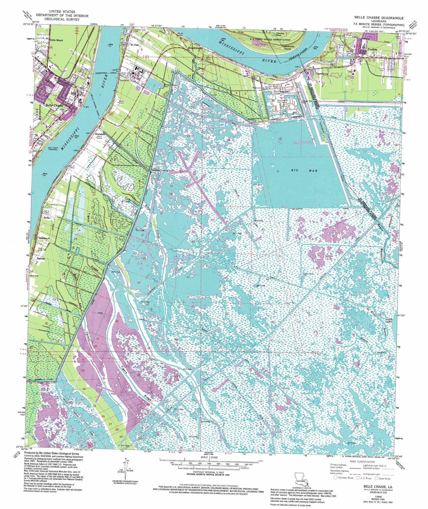
Belle Chasse Topo Map Louisiana
To zoom in, hover over the map of Belle Chasse
USGS Topo Quad 29089g8 - 1:24,000 scale
| Topo Map Name: | Belle Chasse |
| USGS Topo Quad ID: | 29089g8 |
| Print Size: | ca. 21 1/4" wide x 27" high |
| Southeast Coordinates: | 29.75° N latitude / 89.875° W longitude |
| Map Center Coordinates: | 29.8125° N latitude / 89.9375° W longitude |
| U.S. State: | LA |
| Filename: | o29089g8.jpg |
| Download Map JPG Image: | Belle Chasse topo map 1:24,000 scale |
| Map Type: | Topographic |
| Topo Series: | 7.5´ |
| Map Scale: | 1:24,000 |
| Source of Map Images: | United States Geological Survey (USGS) |
| Alternate Map Versions: |
Belle Chasse LA 1951, updated 1952 Download PDF Buy paper map Belle Chasse LA 1951, updated 1960 Download PDF Buy paper map Belle Chasse LA 1966, updated 1968 Download PDF Buy paper map Belle Chasse LA 1966, updated 1973 Download PDF Buy paper map Belle Chasse LA 1966, updated 1980 Download PDF Buy paper map Belle Chasse LA 1966, updated 1986 Download PDF Buy paper map Belle Chasse LA 1966, updated 1991 Download PDF Buy paper map Belle Chasse LA 1966, updated 1994 Download PDF Buy paper map Belle Chasse LA 1999, updated 2000 Download PDF Buy paper map Belle Chasse LA 2012 Download PDF Buy paper map Belle Chasse LA 2015 Download PDF Buy paper map |
1:24,000 Topo Quads surrounding Belle Chasse
Indian Beach |
Spanish Fort |
Little Woods |
Chef Menteur |
Alligator Point |
New Orleans West |
New Orleans East |
Chalmette |
Martello Castle |
Proctor Point |
Lake Cataouatche East |
Bertrandville |
Belle Chasse |
Delacroix |
Yscloskey |
Barataria |
Lafitte |
Phoenix |
Lake Batola |
Lake Cuatro Caballo |
Bay L'Ours |
Three Bayou Bay |
Lake Laurier |
Pointe A La Hache |
Happy Jack |
> Back to 29089e1 at 1:100,000 scale
> Back to 29088a1 at 1:250,000 scale
> Back to U.S. Topo Maps home
Belle Chasse topo map: Gazetteer
Belle Chasse: Airports
Amax Metals Recovery Incorporated Heliport elevation 2m 6′Braithwaite Park Airport elevation 1m 3′
Belle Chasse: Basins
Caernarvon Crevasse elevation 3m 9′Poydras Crevasse elevation 3m 9′
Belle Chasse: Canals
Braithwaite Canal elevation 0m 0′D P Canal elevation 1m 3′
Delacroix Canal elevation 0m 0′
Forty Arpent Canal elevation -2m -7′
Green Avenue Canal elevation 2m 6′
Industry Canal elevation -2m -7′
Mumphry Ditch elevation 1m 3′
Perez Canal elevation -1m -4′
Promised Land Canal elevation 0m 0′
Reggio Canal elevation 1m 3′
Scarsdale Canal elevation 1m 3′
Stella Canal elevation 0m 0′
White Ditch elevation -1m -4′
Belle Chasse: Capes
Twelvemile Point elevation 3m 9′Belle Chasse: Guts
Bayou Duhuy elevation 0m 0′Bayou Mandeville elevation 0m 0′
Cane Ridge Slough elevation 1m 3′
Le Blanc Bayou elevation 0m 0′
Belle Chasse: Lakes
Big Mar elevation 0m 0′Charley Pond elevation 2m 6′
Belle Chasse: Levees
English Turn Revetment elevation 3m 9′Poydras Revetment elevation 3m 9′
Scarsdale Revetment elevation 2m 6′
Belle Chasse: Oilfields
Caskett Bayou Gas Field elevation 1m 3′Dalcour Gas Field elevation 1m 3′
Belle Chasse: Parks
Saint Bernard State Park elevation 1m 3′Belle Chasse: Populated Places
Belle Chasse elevation 2m 6′Braithwaite elevation 2m 6′
Caernarvon elevation 1m 3′
Dalcour elevation 2m 6′
Noble Manor elevation -1m -4′
Port Nickel elevation 2m 6′
Poydras elevation 2m 6′
Saint Clair elevation 3m 9′
Scarsdale elevation 2m 6′
Stella elevation 2m 6′
Belle Chasse: Post Offices
Belle Chasse Post Office elevation 2m 6′Belle Chasse: Ridges
Tigers Ridge elevation 0m 0′Belle Chasse digital topo map on disk
Buy this Belle Chasse topo map showing relief, roads, GPS coordinates and other geographical features, as a high-resolution digital map file on DVD:
Gulf Coast (LA, MS, AL, FL) & Southwestern Georgia
Buy digital topo maps: Gulf Coast (LA, MS, AL, FL) & Southwestern Georgia
 & Southwestern Georgia map DVD")