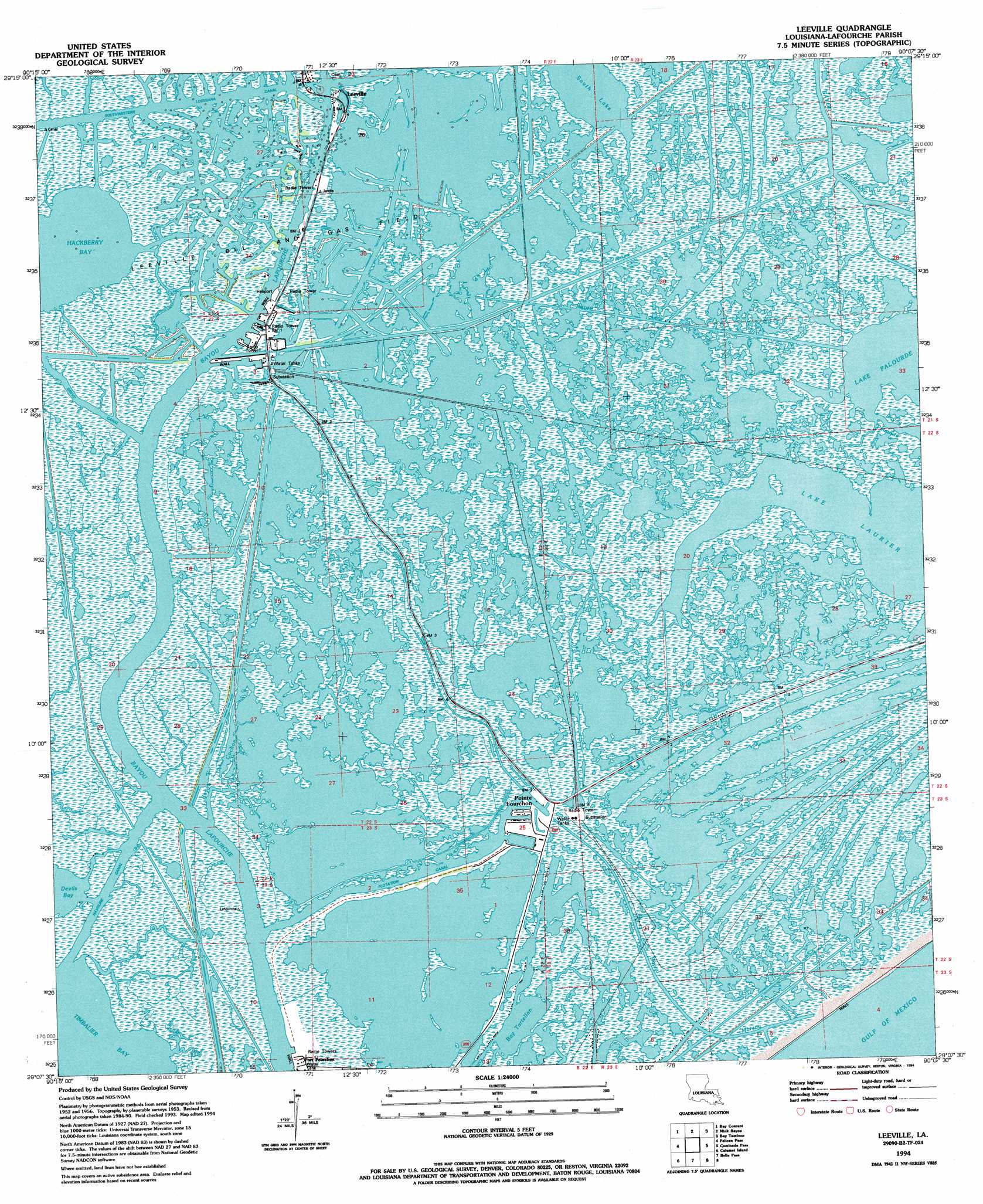
Leeville Topo Map Louisiana
To zoom in, hover over the map of Leeville
USGS Topo Quad 29090b2 - 1:24,000 scale
| Topo Map Name: | Leeville |
| USGS Topo Quad ID: | 29090b2 |
| Print Size: | ca. 21 1/4" wide x 27" high |
| Southeast Coordinates: | 29.125° N latitude / 90.125° W longitude |
| Map Center Coordinates: | 29.1875° N latitude / 90.1875° W longitude |
| U.S. State: | LA |
| Filename: | o29090b2.jpg |
| Download Map JPG Image: | Leeville topo map 1:24,000 scale |
| Map Type: | Topographic |
| Topo Series: | 7.5´ |
| Map Scale: | 1:24,000 |
| Source of Map Images: | United States Geological Survey (USGS) |
| Alternate Map Versions: |
Leeville LA 1994, updated 1994 Download PDF Buy paper map Leeville LA 1998, updated 2001 Download PDF Buy paper map Leeville LA 2012 Download PDF Buy paper map Leeville LA 2015 Download PDF Buy paper map |
1:24,000 Topo Quads surrounding Leeville
Lake Bully Camp |
Golden Meadow |
Golden Meadow Farms |
Bay Dosgris |
Wilkinson Bay |
Lake Felicity |
Bay Courant |
Mink Bayou |
Bay Tambour |
Barataria Pass |
Jacko Bay |
Pelican Pass |
Leeville |
Caminada Pass |
Grand Isle |
Timbalier Island |
Calumet Island |
Belle Pass |
||
> Back to 29090a1 at 1:100,000 scale
> Back to 29090a1 at 1:250,000 scale
> Back to U.S. Topo Maps home
Leeville topo map: Gazetteer
Leeville: Airports
Chevron USA Incorporated Heliport elevation 1m 3′Compressor Station 524 Heliport elevation 0m 0′
Leeville: Bays
Hackberry Bay elevation 0m 0′Leeville: Bridges
Leeville Bridge elevation 0m 0′Leeville: Canals
Flotation Canal elevation 0m 0′Greys Canal elevation 0m 0′
Havoline Canal elevation 0m 0′
Piroque Canal elevation 0m 0′
William Canal elevation 0m 0′
Leeville: Guts
Bayou Cochon elevation 0m 0′Bayou Ferblanc elevation 0m 0′
Bayou Moreau elevation 0m 0′
Leeville: Lakes
Bay Tartellon elevation 0m 0′Lake Laurier elevation 0m 0′
Lake Palourde elevation 0m 0′
South Lake elevation 0m 0′
Leeville: Parks
Wisner State Wildlife Management Area elevation 0m 0′Leeville: Populated Places
Leeville elevation 0m 0′Leeville digital topo map on disk
Buy this Leeville topo map showing relief, roads, GPS coordinates and other geographical features, as a high-resolution digital map file on DVD: