Pelican Pass Topo Map Louisiana
To zoom in, hover over the map of Pelican Pass
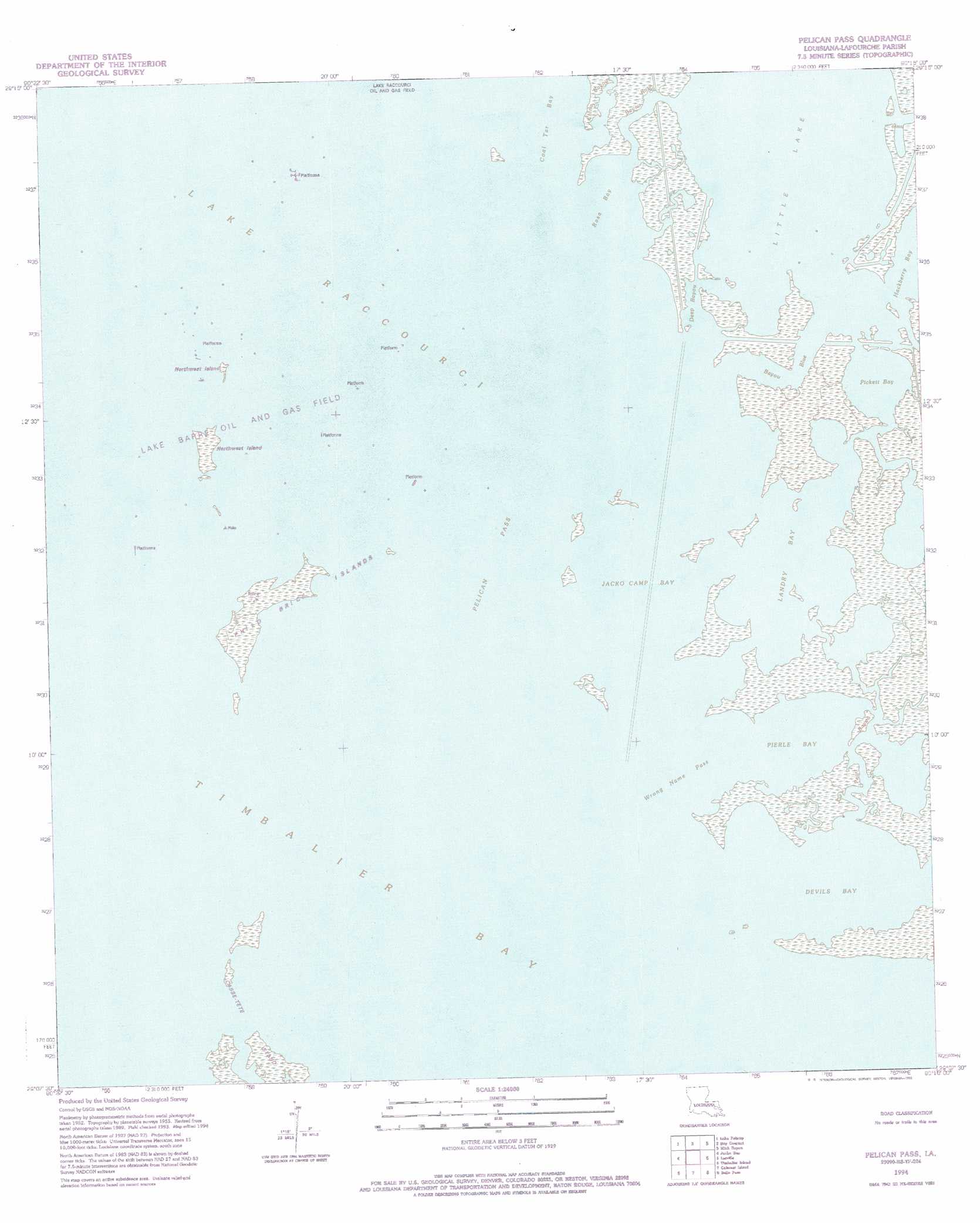
USGS Topo Quad 29090b3 - 1:24,000 scale
| Topo Map Name: | Pelican Pass |
| USGS Topo Quad ID: | 29090b3 |
| Print Size: | ca. 21 1/4" wide x 27" high |
| Southeast Coordinates: | 29.125° N latitude / 90.25° W longitude |
| Map Center Coordinates: | 29.1875° N latitude / 90.3125° W longitude |
| U.S. State: | LA |
| Filename: | o29090b3.jpg |
| Download Map JPG Image: | Pelican Pass topo map 1:24,000 scale |
| Map Type: | Topographic |
| Topo Series: | 7.5´ |
| Map Scale: | 1:24,000 |
| Source of Map Images: | United States Geological Survey (USGS) |
| Alternate Map Versions: |
Pelican Pass LA 1956, updated 1959 Download PDF Buy paper map Pelican Pass LA 1956, updated 1965 Download PDF Buy paper map Pelican Pass LA 1956, updated 1973 Download PDF Buy paper map Pelican Pass LA 1956, updated 1980 Download PDF Buy paper map Pelican Pass LA 1994, updated 1994 Download PDF Buy paper map Pelican Pass LA 1998, updated 2003 Download PDF Buy paper map Pelican Pass LA 2012 Download PDF Buy paper map Pelican Pass LA 2015 Download PDF Buy paper map |
1:24,000 Topo Quads surrounding Pelican Pass
Montegut |
Lake Bully Camp |
Golden Meadow |
Golden Meadow Farms |
Bay Dosgris |
Lake Tambour |
Lake Felicity |
Bay Courant |
Mink Bayou |
Bay Tambour |
Lake La Graisse |
Jacko Bay |
Pelican Pass |
Leeville |
Caminada Pass |
Cat Island Pass |
Timbalier Island |
Calumet Island |
Belle Pass |
|
> Back to 29090a1 at 1:100,000 scale
> Back to 29090a1 at 1:250,000 scale
> Back to U.S. Topo Maps home
Pelican Pass topo map: Gazetteer
Pelican Pass: Bays
Coal Tar Bay elevation 0m 0′Devils Bay elevation 0m 0′
Jacko Camp Bay elevation 0m 0′
Lake Raccourci elevation 0m 0′
Landry Bay elevation 0m 0′
Little Lake elevation 0m 0′
Pickett Bay elevation 0m 0′
Pierle Bay elevation 0m 0′
Rosa Bay elevation 0m 0′
Shallow Bayou elevation 0m 0′
Timbalier Bay elevation 0m 0′
Pelican Pass: Capes
Capon Point elevation 1m 3′Pelican Pass: Channels
Pelican Pass elevation 0m 0′Wrong Name Pass elevation 0m 0′
Pelican Pass: Guts
Bayou Blue elevation 0m 0′Bayou Rosa elevation 2m 6′
Deep Bayou elevation 0m 0′
Pearl Bayou elevation 0m 0′
Pelican Pass: Islands
Devils Island elevation 2m 6′Northwest Island elevation 2m 6′
Philo Brice Islands elevation 2m 6′
Pelican Pass: Oilfields
Lake Barre Oil and Gas Field elevation 0m 0′Pelican Pass digital topo map on disk
Buy this Pelican Pass topo map showing relief, roads, GPS coordinates and other geographical features, as a high-resolution digital map file on DVD: