Lake Felicity Topo Map Louisiana
To zoom in, hover over the map of Lake Felicity
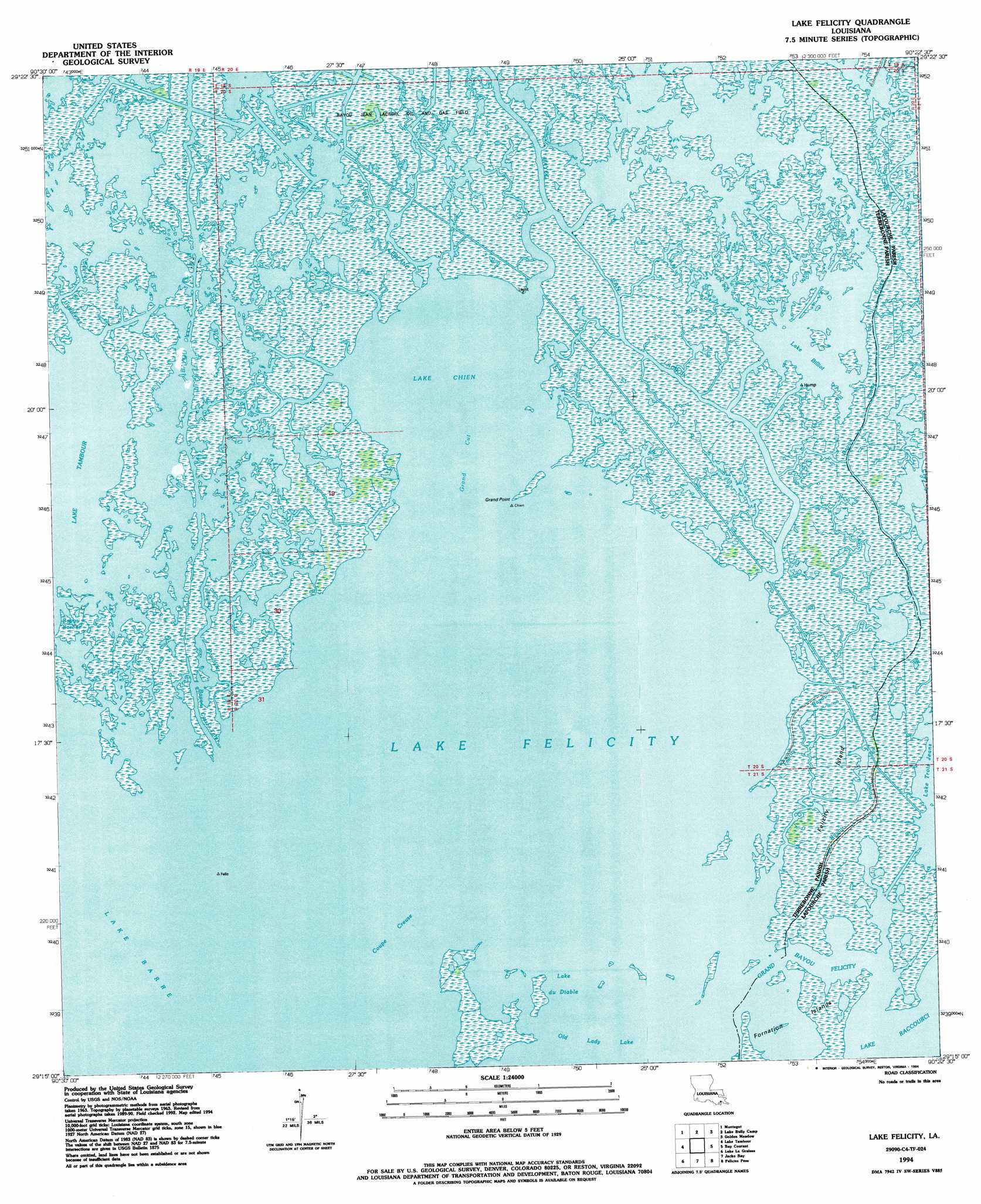
USGS Topo Quad 29090c4 - 1:24,000 scale
| Topo Map Name: | Lake Felicity |
| USGS Topo Quad ID: | 29090c4 |
| Print Size: | ca. 21 1/4" wide x 27" high |
| Southeast Coordinates: | 29.25° N latitude / 90.375° W longitude |
| Map Center Coordinates: | 29.3125° N latitude / 90.4375° W longitude |
| U.S. State: | LA |
| Filename: | o29090c4.jpg |
| Download Map JPG Image: | Lake Felicity topo map 1:24,000 scale |
| Map Type: | Topographic |
| Topo Series: | 7.5´ |
| Map Scale: | 1:24,000 |
| Source of Map Images: | United States Geological Survey (USGS) |
| Alternate Map Versions: |
Lake Felicity LA 1964, updated 1965 Download PDF Buy paper map Lake Felicity LA 1964, updated 1976 Download PDF Buy paper map Lake Felicity LA 1964, updated 1980 Download PDF Buy paper map Lake Felicity LA 1964, updated 1983 Download PDF Buy paper map Lake Felicity LA 1994, updated 1994 Download PDF Buy paper map Lake Felicity LA 2012 Download PDF Buy paper map Lake Felicity LA 2015 Download PDF Buy paper map |
1:24,000 Topo Quads surrounding Lake Felicity
Houma |
Bourg |
Larose |
Cut Off |
Bay L'Ours |
Dulac |
Montegut |
Lake Bully Camp |
Golden Meadow |
Golden Meadow Farms |
Lake Quitman |
Lake Tambour |
Lake Felicity |
Bay Courant |
Mink Bayou |
Cocodrie |
Lake La Graisse |
Jacko Bay |
Pelican Pass |
Leeville |
Eastern Isles Dernieres |
Cat Island Pass |
Timbalier Island |
Calumet Island |
Belle Pass |
> Back to 29090a1 at 1:100,000 scale
> Back to 29090a1 at 1:250,000 scale
> Back to U.S. Topo Maps home
Lake Felicity topo map: Gazetteer
Lake Felicity: Bays
Lake Chien elevation 0m 0′Lake Felicity elevation 0m 0′
Lake Felicity: Capes
Grand Point elevation 1m 3′Lake Felicity: Channels
Coupe Creuse elevation 0m 0′Deep Cut elevation 0m 0′
Grand Cut elevation 0m 0′
Lake du Diable elevation 0m 0′
Lake Felicity: Guts
Bayou Casse-Tete elevation 1m 3′Bayou de la Valle elevation 0m 0′
Bayou Jean Lacroix elevation 0m 0′
Bayou Leblanc elevation 1m 3′
Bayou Poulailler elevation 1m 3′
Felicity Bayou elevation 1m 3′
Grand Bayou Felicity elevation 0m 0′
Lake de la Valle elevation 0m 0′
Lake Felicity: Lakes
Lake Billiot elevation 0m 0′Lake Felicity: Streams
Bayou Barbue elevation 0m 0′Bayou Guillaume elevation 0m 0′
Bayou Pointe Au Chien elevation 1m 3′
Bayou Saint Jean Charles elevation 0m 0′
Lake Felicity: Swamps
Felicity Island elevation 1m 3′Lake Felicity digital topo map on disk
Buy this Lake Felicity topo map showing relief, roads, GPS coordinates and other geographical features, as a high-resolution digital map file on DVD: