Lake Mechant Topo Map Louisiana
To zoom in, hover over the map of Lake Mechant
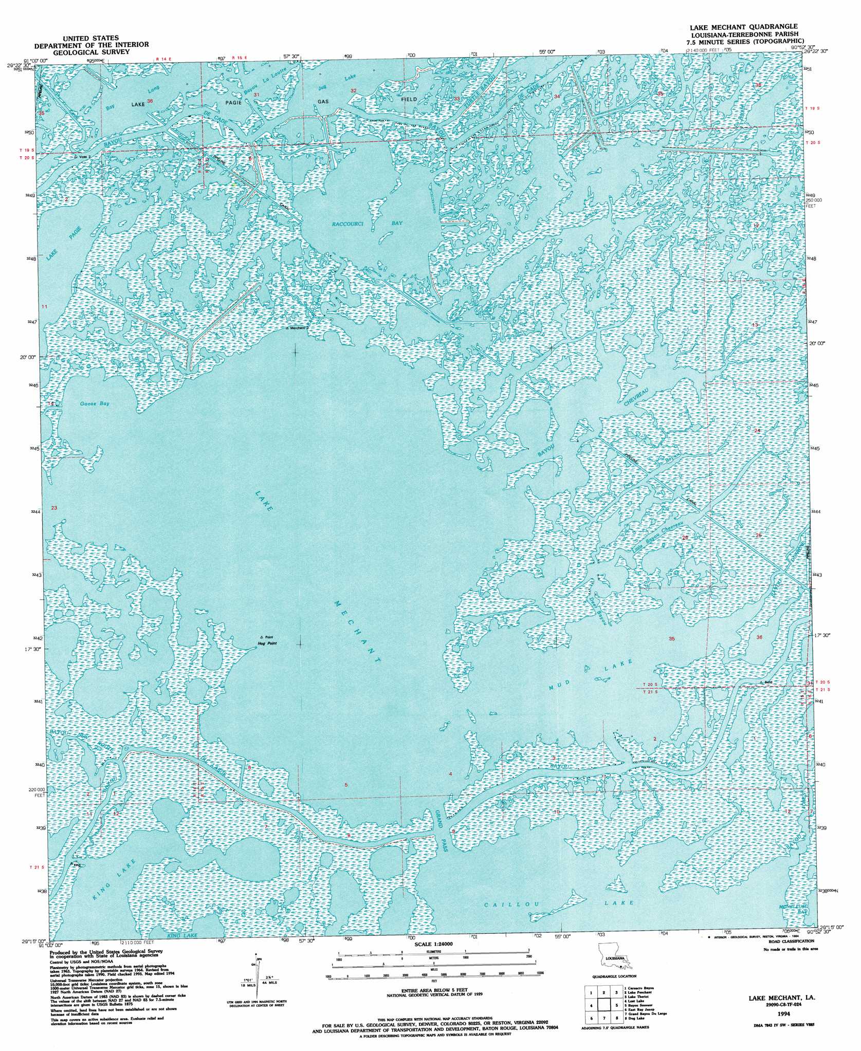
USGS Topo Quad 29090c8 - 1:24,000 scale
| Topo Map Name: | Lake Mechant |
| USGS Topo Quad ID: | 29090c8 |
| Print Size: | ca. 21 1/4" wide x 27" high |
| Southeast Coordinates: | 29.25° N latitude / 90.875° W longitude |
| Map Center Coordinates: | 29.3125° N latitude / 90.9375° W longitude |
| U.S. State: | LA |
| Filename: | o29090c8.jpg |
| Download Map JPG Image: | Lake Mechant topo map 1:24,000 scale |
| Map Type: | Topographic |
| Topo Series: | 7.5´ |
| Map Scale: | 1:24,000 |
| Source of Map Images: | United States Geological Survey (USGS) |
| Alternate Map Versions: |
Lake Mechant LA 1964, updated 1965 Download PDF Buy paper map Lake Mechant LA 1964, updated 1976 Download PDF Buy paper map Lake Mechant LA 1964, updated 1981 Download PDF Buy paper map Lake Mechant LA 1964, updated 1989 Download PDF Buy paper map Lake Mechant LA 1994, updated 1994 Download PDF Buy paper map Lake Mechant LA 2012 Download PDF Buy paper map Lake Mechant LA 2015 Download PDF Buy paper map |
1:24,000 Topo Quads surrounding Lake Mechant
Morgan City Sw |
Morgan City Se |
Bayou Cocodrie |
Humphreys |
Houma |
Plumb Bayou |
Carencro Bayou |
Lake Penchant |
Lake Theriot |
Dulac |
Fourleague Bay |
Lost Lake |
Lake Mechant |
Bayou Sauveur |
Lake Quitman |
Oyster Bayou |
East Bay Junop |
Grand Bayou Du Large |
Dog Lake |
Cocodrie |
Western Isles Dernieres |
Central Isles Derniere |
Eastern Isles Dernieres |
> Back to 29090a1 at 1:100,000 scale
> Back to 29090a1 at 1:250,000 scale
> Back to U.S. Topo Maps home
Lake Mechant topo map: Gazetteer
Lake Mechant: Canals
Voss Canal elevation 1m 3′Lake Mechant: Capes
Hog Point elevation 1m 3′Lake Mechant: Channels
Grand Pass elevation 0m 0′Lake Mechant: Guts
Bayou Chevreau elevation 0m 0′Bayou Dufrene elevation 0m 0′
Bayou Jones elevation -2m -7′
Bayou New Route elevation 0m 0′
Deer Bayou elevation 0m 0′
Fred Bayou elevation 0m 0′
Little Bayou Chevreau elevation 0m 0′
Raccourci Bayou elevation 0m 0′
Lake Mechant: Lakes
Bay Long elevation 0m 0′Goose Bay elevation 0m 0′
Jug Lake elevation 0m 0′
Lake Mechant elevation 0m 0′
Lake Washa elevation 0m 0′
Mud Lake elevation 0m 0′
Raccourci Bay elevation 0m 0′
Lake Mechant: Streams
Bayou la Loutre elevation 0m 0′Small Bayou La Pointe elevation 1m 3′
Turtle Bayou elevation 0m 0′
Lake Mechant digital topo map on disk
Buy this Lake Mechant topo map showing relief, roads, GPS coordinates and other geographical features, as a high-resolution digital map file on DVD: