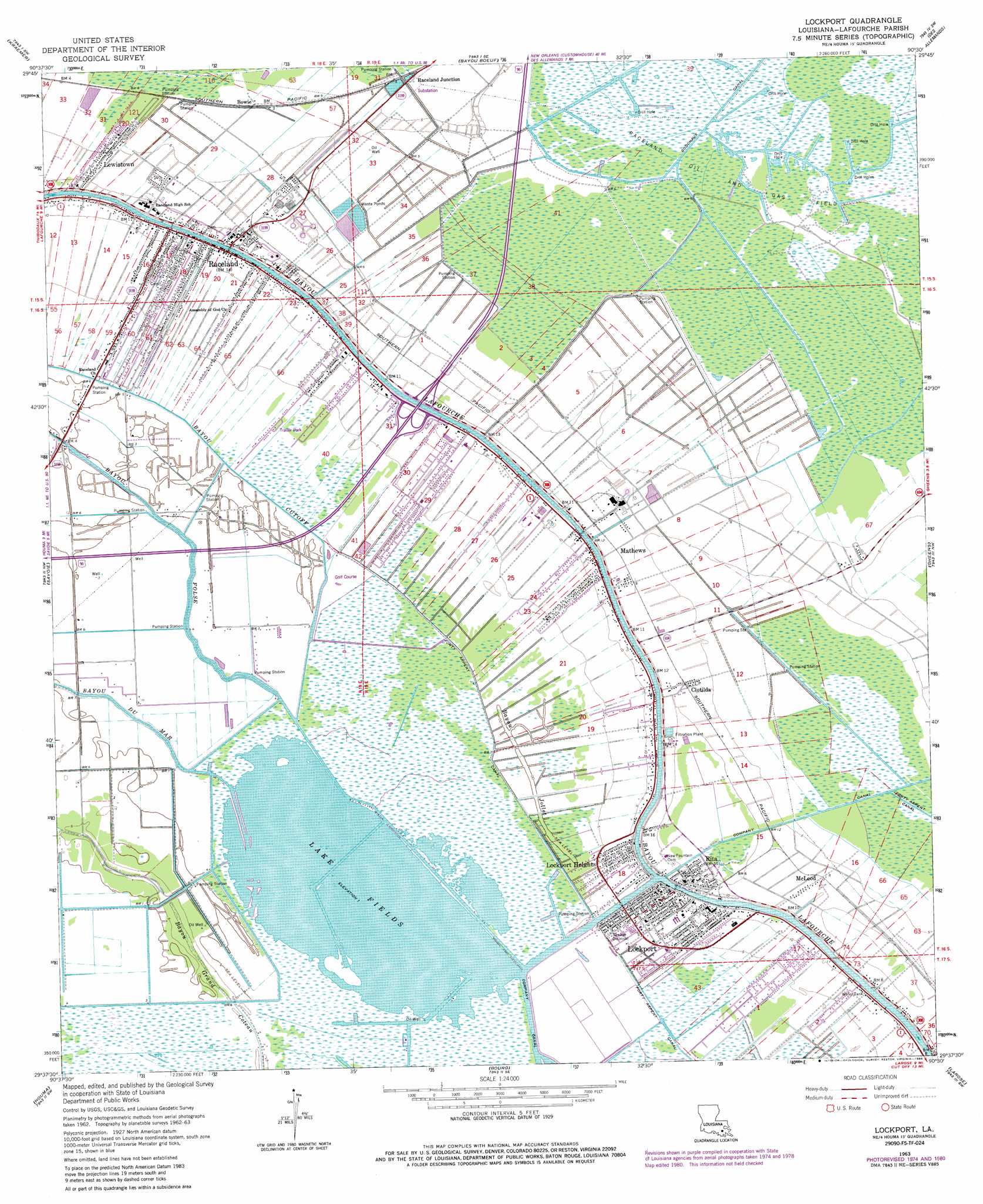
Lockport Topo Map Louisiana
To zoom in, hover over the map of Lockport
USGS Topo Quad 29090f5 - 1:24,000 scale
| Topo Map Name: | Lockport |
| USGS Topo Quad ID: | 29090f5 |
| Print Size: | ca. 21 1/4" wide x 27" high |
| Southeast Coordinates: | 29.625° N latitude / 90.5° W longitude |
| Map Center Coordinates: | 29.6875° N latitude / 90.5625° W longitude |
| U.S. State: | LA |
| Filename: | o29090f5.jpg |
| Download Map JPG Image: | Lockport topo map 1:24,000 scale |
| Map Type: | Topographic |
| Topo Series: | 7.5´ |
| Map Scale: | 1:24,000 |
| Source of Map Images: | United States Geological Survey (USGS) |
| Alternate Map Versions: |
Lockport LA 1963, updated 1964 Download PDF Buy paper map Lockport LA 1963, updated 1975 Download PDF Buy paper map Lockport LA 1963, updated 1981 Download PDF Buy paper map Lockport LA 1963, updated 1986 Download PDF Buy paper map Lockport LA 1998, updated 2000 Download PDF Buy paper map Lockport LA 2012 Download PDF Buy paper map Lockport LA 2015 Download PDF Buy paper map |
1:24,000 Topo Quads surrounding Lockport
Lagan |
Lower Vacherie |
Lac Des Allemands |
Hahnville |
Luling |
Thibodaux |
Kraemer |
Bayou Boeuf |
Des Allemands |
Lake Cataouatche West |
Gray |
Savoie |
Lockport |
Gheens |
Catahoula Bay |
Humphreys |
Houma |
Bourg |
Larose |
Cut Off |
Lake Theriot |
Dulac |
Montegut |
Lake Bully Camp |
Golden Meadow |
> Back to 29090e1 at 1:100,000 scale
> Back to 29090a1 at 1:250,000 scale
> Back to U.S. Topo Maps home
Lockport topo map: Gazetteer
Lockport: Airports
Raceland Station Heliport elevation 3m 9′Saint Anne Heliport elevation 2m 6′
Lockport: Dams
Louisiana Noname 95 Dam elevation 0m 0′Lockport: Guts
Bayou Jollet elevation 0m 0′Lockport: Lakes
Lake Fields elevation 0m 0′Lockport: Oilfields
Raceland Oil and Gas Field elevation 1m 3′Lockport: Populated Places
Bowie elevation 1m 3′Clotilda elevation 2m 6′
Godchaux elevation 3m 9′
Lewistown elevation 2m 6′
Lockport elevation 3m 9′
Lockport Heights elevation 1m 3′
Mathews elevation 3m 9′
McLeod elevation 2m 6′
New Hope (historical) elevation 1m 3′
Raceland elevation 4m 13′
Raceland Junction elevation 1m 3′
Ravenwood (historical) elevation 2m 6′
Rita elevation 2m 6′
Utopia (historical) elevation 1m 3′
Lockport: Post Offices
Lockport Post Office elevation 3m 9′Lockport: Ridges
Love Ridge elevation 0m 0′Lockport: Streams
Bayou Cut Off elevation 1m 3′Bayou Du Mar elevation 0m 0′
Bayou Folse elevation 0m 0′
Lockport digital topo map on disk
Buy this Lockport topo map showing relief, roads, GPS coordinates and other geographical features, as a high-resolution digital map file on DVD: