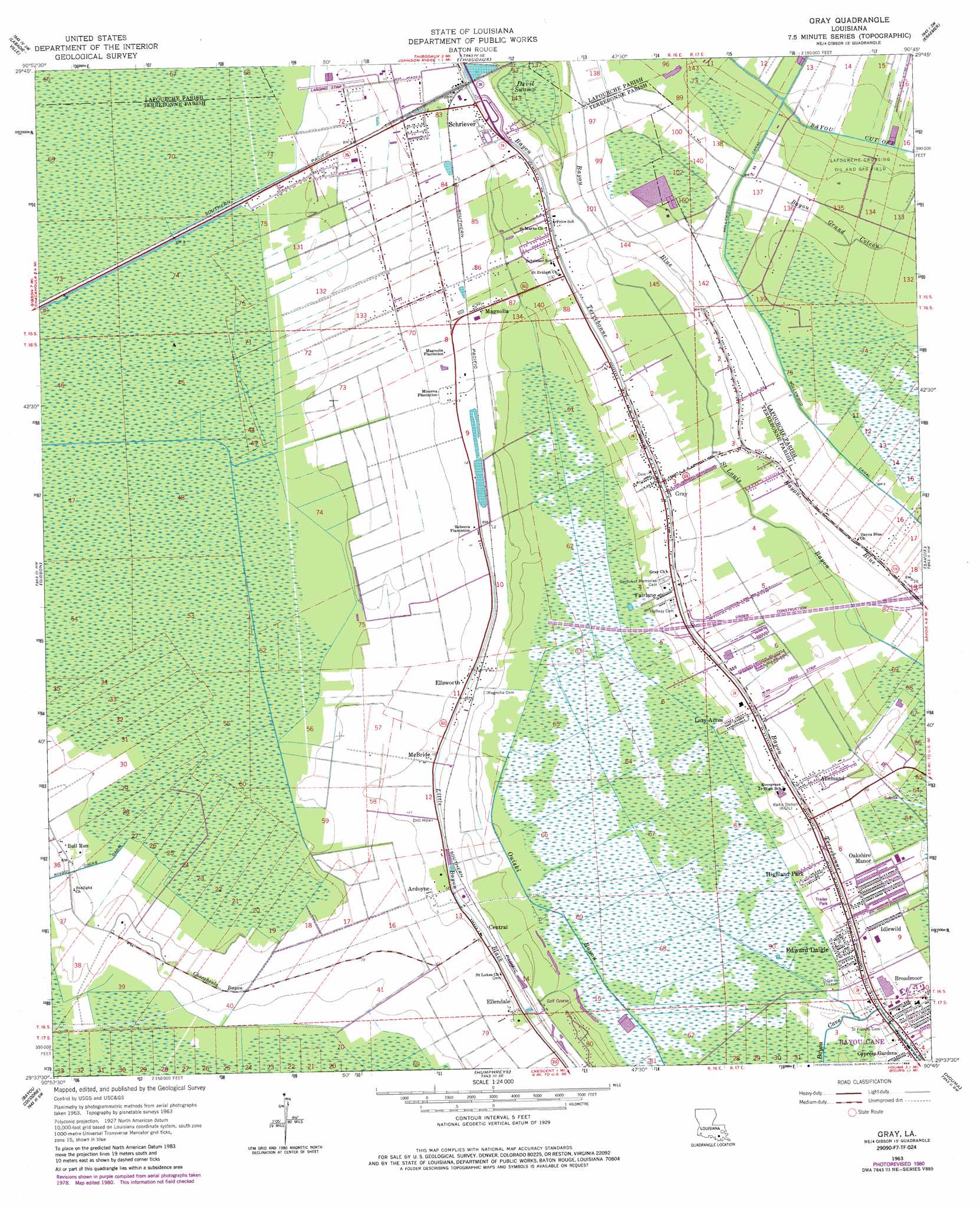
Gray Topo Map Louisiana
To zoom in, hover over the map of Gray
USGS Topo Quad 29090f7 - 1:24,000 scale
| Topo Map Name: | Gray |
| USGS Topo Quad ID: | 29090f7 |
| Print Size: | ca. 21 1/4" wide x 27" high |
| Southeast Coordinates: | 29.625° N latitude / 90.75° W longitude |
| Map Center Coordinates: | 29.6875° N latitude / 90.8125° W longitude |
| U.S. State: | LA |
| Filename: | o29090f7.jpg |
| Download Map JPG Image: | Gray topo map 1:24,000 scale |
| Map Type: | Topographic |
| Topo Series: | 7.5´ |
| Map Scale: | 1:24,000 |
| Source of Map Images: | United States Geological Survey (USGS) |
| Alternate Map Versions: |
Gray LA 1963, updated 1965 Download PDF Buy paper map Gray LA 1963, updated 1976 Download PDF Buy paper map Gray LA 1963, updated 1981 Download PDF Buy paper map Gray LA 1963, updated 1986 Download PDF Buy paper map Gray LA 1998, updated 2000 Download PDF Buy paper map Gray LA 2012 Download PDF Buy paper map Gray LA 2015 Download PDF Buy paper map |
1:24,000 Topo Quads surrounding Gray
Napoleonville |
Madewood |
Lagan |
Lower Vacherie |
Lac Des Allemands |
Grassy Lake |
Labadieville |
Thibodaux |
Kraemer |
Bayou Boeuf |
Amelia |
Gibson |
Gray |
Savoie |
Lockport |
Morgan City Se |
Bayou Cocodrie |
Humphreys |
Houma |
Bourg |
Carencro Bayou |
Lake Penchant |
Lake Theriot |
Dulac |
Montegut |
> Back to 29090e1 at 1:100,000 scale
> Back to 29090a1 at 1:250,000 scale
> Back to U.S. Topo Maps home
Gray topo map: Gazetteer
Gray: Airports
Southland Strip elevation 2m 6′Southland Strip Number 2 elevation 2m 6′
Thibodaux Municipal Airport elevation 2m 6′
Transco Schriever Heliport elevation 2m 6′
Troop C Heliport elevation 3m 9′
Gray: Populated Places
Allemand elevation 3m 9′Ardoyne elevation 3m 9′
Bull Run elevation 1m 3′
Central elevation 3m 9′
Country Hollow elevation 2m 6′
Cypress Gardens elevation 3m 9′
Edward Daigle elevation 3m 9′
Ellendale elevation 3m 9′
Ellsworth elevation 3m 9′
Fairlane elevation 4m 13′
Gray elevation 3m 9′
Highland Park elevation 3m 9′
Idlewild elevation 2m 6′
Isle of Cuba elevation 3m 9′
Lazy Acres elevation 2m 6′
Magnolia elevation 3m 9′
Magnolia Plantation elevation 4m 13′
McBride elevation 3m 9′
Minerva Plantation elevation 3m 9′
Oakshire Manor elevation 2m 6′
Rebecca Plantation elevation 4m 13′
Schriever elevation 4m 13′
Gray: Post Offices
Gray Post Office elevation 3m 9′Schriever Post Office elevation 4m 13′
Gray: Streams
Chacahoula Bayou elevation 2m 6′Gray digital topo map on disk
Buy this Gray topo map showing relief, roads, GPS coordinates and other geographical features, as a high-resolution digital map file on DVD: