Lower Vacherie Topo Map Louisiana
To zoom in, hover over the map of Lower Vacherie
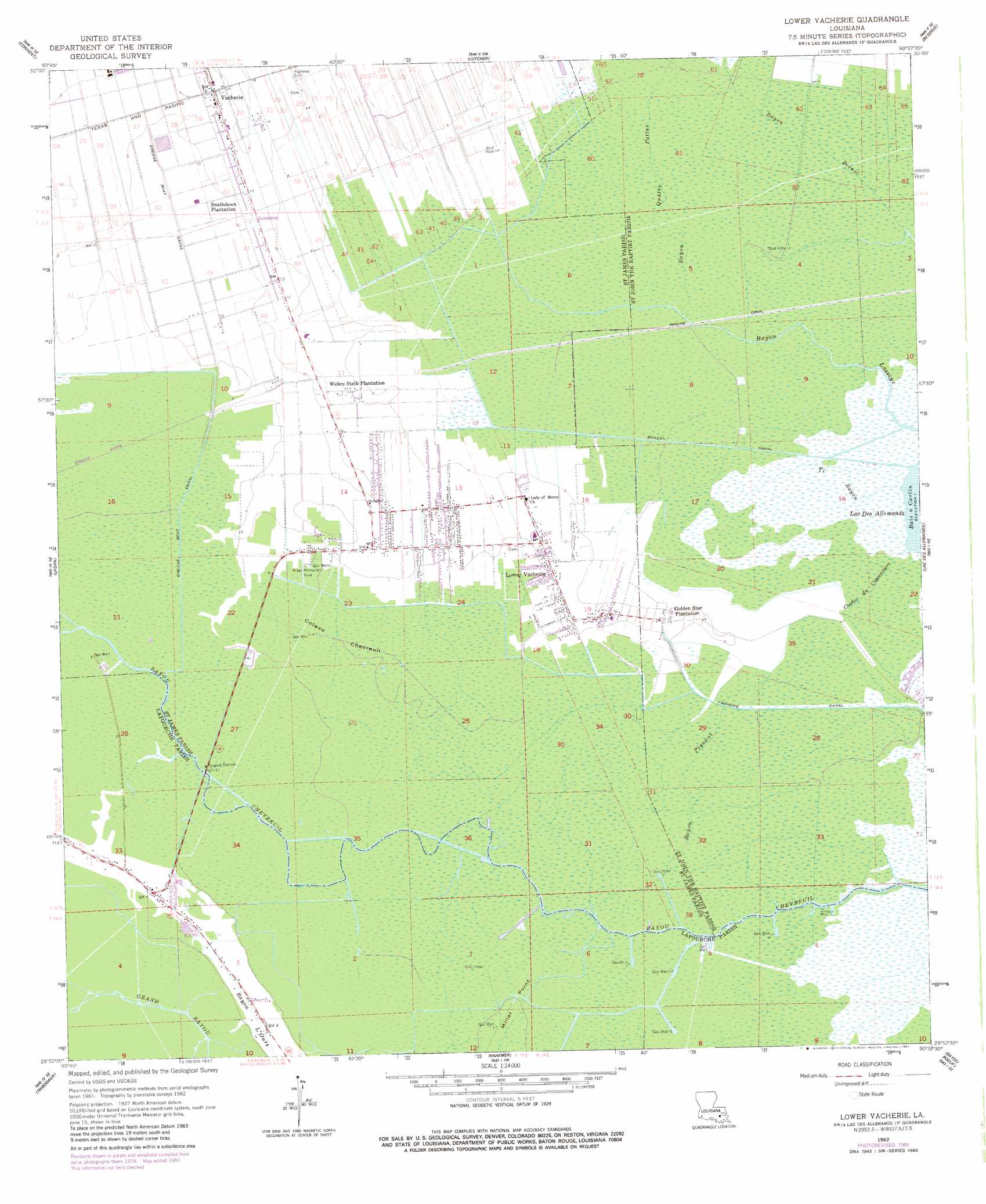
USGS Topo Quad 29090h6 - 1:24,000 scale
| Topo Map Name: | Lower Vacherie |
| USGS Topo Quad ID: | 29090h6 |
| Print Size: | ca. 21 1/4" wide x 27" high |
| Southeast Coordinates: | 29.875° N latitude / 90.625° W longitude |
| Map Center Coordinates: | 29.9375° N latitude / 90.6875° W longitude |
| U.S. State: | LA |
| Filename: | o29090h6.jpg |
| Download Map JPG Image: | Lower Vacherie topo map 1:24,000 scale |
| Map Type: | Topographic |
| Topo Series: | 7.5´ |
| Map Scale: | 1:24,000 |
| Source of Map Images: | United States Geological Survey (USGS) |
| Alternate Map Versions: |
Lower Vacherie LA 1962, updated 1963 Download PDF Buy paper map Lower Vacherie LA 1962, updated 1973 Download PDF Buy paper map Lower Vacherie LA 1962, updated 1981 Download PDF Buy paper map Lower Vacherie LA 1962, updated 1981 Download PDF Buy paper map Lower Vacherie LA 1998, updated 2000 Download PDF Buy paper map Lower Vacherie LA 2012 Download PDF Buy paper map Lower Vacherie LA 2015 Download PDF Buy paper map |
1:24,000 Topo Quads surrounding Lower Vacherie
Gonzales |
Sorrento |
Mount Airy Nw |
Mount Airy Ne |
Ruddock |
Donaldsonville |
Convent |
Lutcher |
Reserve |
Laplace |
Madewood |
Lagan |
Lower Vacherie |
Lac Des Allemands |
Hahnville |
Labadieville |
Thibodaux |
Kraemer |
Bayou Boeuf |
Des Allemands |
Gibson |
Gray |
Savoie |
Lockport |
Gheens |
> Back to 29090e1 at 1:100,000 scale
> Back to 29090a1 at 1:250,000 scale
> Back to U.S. Topo Maps home
Lower Vacherie topo map: Gazetteer
Lower Vacherie: Areas
Coteau Chevreuil elevation 1m 3′Lower Vacherie: Canals
Brazan Canal elevation 1m 3′Vacherie Canal elevation 1m 3′
Lower Vacherie: Flats
Miller Point elevation 1m 3′Lower Vacherie: Oilfields
Bayou Chevreuil Gas Field elevation 0m 0′Citamon Bayou Gas Field elevation 0m 0′
Lower Vacherie Gas Field elevation 1m 3′
Lower Vacherie: Parks
Miles Memorial Park elevation 1m 3′Lower Vacherie: Populated Places
Armant elevation 5m 16′Golden Star Plantation elevation 2m 6′
Lower Vacherie elevation 2m 6′
North Vacherie elevation 2m 6′
South Vacherie elevation 0m 0′
Southdown Plantation elevation 3m 9′
Webre Steib Plantation elevation 2m 6′
Lower Vacherie: Streams
Bayou Piquant elevation 0m 0′Bayou Quatre Pattes elevation 1m 3′
Coulee du Cimentiere elevation 0m 0′
Ti Bayou elevation 0m 0′
Lower Vacherie digital topo map on disk
Buy this Lower Vacherie topo map showing relief, roads, GPS coordinates and other geographical features, as a high-resolution digital map file on DVD: