Belle Isle Topo Map Louisiana
To zoom in, hover over the map of Belle Isle
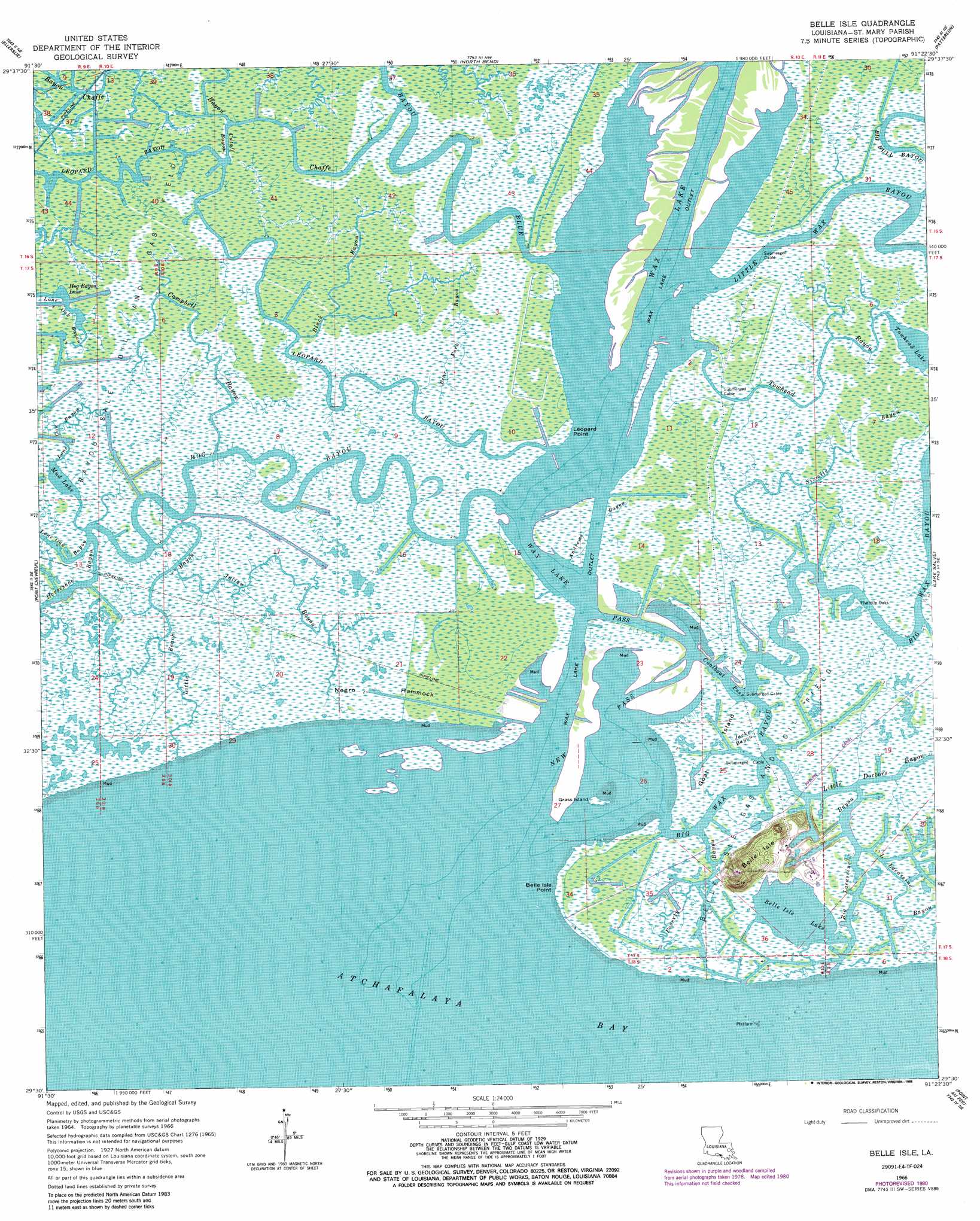
USGS Topo Quad 29091e4 - 1:24,000 scale
| Topo Map Name: | Belle Isle |
| USGS Topo Quad ID: | 29091e4 |
| Print Size: | ca. 21 1/4" wide x 27" high |
| Southeast Coordinates: | 29.5° N latitude / 91.375° W longitude |
| Map Center Coordinates: | 29.5625° N latitude / 91.4375° W longitude |
| U.S. State: | LA |
| Filename: | o29091e4.jpg |
| Download Map JPG Image: | Belle Isle topo map 1:24,000 scale |
| Map Type: | Topographic |
| Topo Series: | 7.5´ |
| Map Scale: | 1:24,000 |
| Source of Map Images: | United States Geological Survey (USGS) |
| Alternate Map Versions: |
Belle Isle LA 1966, updated 1967 Download PDF Buy paper map Belle Isle LA 1966, updated 1981 Download PDF Buy paper map Belle Isle LA 1966, updated 1988 Download PDF Buy paper map Belle Isle LA 1994, updated 1998 Download PDF Buy paper map Belle Isle LA 1998, updated 2000 Download PDF Buy paper map Belle Isle LA 2012 Download PDF Buy paper map Belle Isle LA 2015 Download PDF Buy paper map |
1:24,000 Topo Quads surrounding Belle Isle
Kemper |
Franklin |
Centerville |
Tiger Island |
Napoleonville Sw |
Marone Point |
Ellerslie |
North Bend |
Patterson |
Morgan City |
Lake Point |
Point Chevreuil |
Belle Isle |
Lake Salve |
Morgan City Sw |
Point Au Fer Ne |
Plumb Bayou |
|||
Point Au Fer |
Fourleague Bay |
> Back to 29091e1 at 1:100,000 scale
> Back to 29090a1 at 1:250,000 scale
> Back to U.S. Topo Maps home
Belle Isle topo map: Gazetteer
Belle Isle: Canals
Horseshoe Bayou elevation 0m 0′Belle Isle: Capes
Belle Isle Point elevation 0m 0′Leopard Point elevation 0m 0′
Belle Isle: Channels
Coalboat Pass elevation 0m 0′New Pass elevation 0m 0′
Wax Lake Pass elevation 0m 0′
Belle Isle: Guts
Big Lacassine Bayou elevation 0m 0′Little Beach Bayou elevation 0m 0′
Little Lacassine Bayou elevation 1m 3′
Belle Isle: Islands
Belle Isle elevation 5m 16′Goat Island elevation 0m 0′
Grass Island elevation 1m 3′
Negro Hammock elevation 1m 3′
Belle Isle: Lakes
Belle Isle Lake elevation 0m 0′Hog Bayou Lake elevation 0m 0′
Mud Lake elevation 0m 0′
Towhead Lake elevation 0m 0′
Wax Lake elevation 1m 3′
Belle Isle: Oilfields
Belle Isle Gas and Oil Field elevation 0m 0′Belle Isle: Populated Places
Fivemile Oaks elevation 1m 3′Belle Isle: Streams
Andrews Bayou elevation 0m 0′Bayou Blue elevation 0m 0′
Bayou Chaffe elevation 0m 0′
Bear Fork Bayou elevation 0m 0′
Big Bull Bayou elevation 0m 0′
Big Wax Bayou elevation 0m 0′
Black Bayou elevation 0m 0′
Campbell Bayou elevation 0m 0′
Cutoff Bayou elevation 0m 0′
Hog Bayou elevation 0m 0′
Jacks Bayou elevation 0m 0′
Julian Bayou elevation 0m 0′
Leopard Bayou elevation 0m 0′
Little Doctors Bayou elevation 0m 0′
Little Wax Bayou elevation 0m 0′
Myrtle Bayou elevation 0m 0′
Poverty Bayou elevation 0m 0′
Sixmile Bayou elevation 0m 0′
Towhead Bayou elevation 0m 0′
Belle Isle digital topo map on disk
Buy this Belle Isle topo map showing relief, roads, GPS coordinates and other geographical features, as a high-resolution digital map file on DVD: