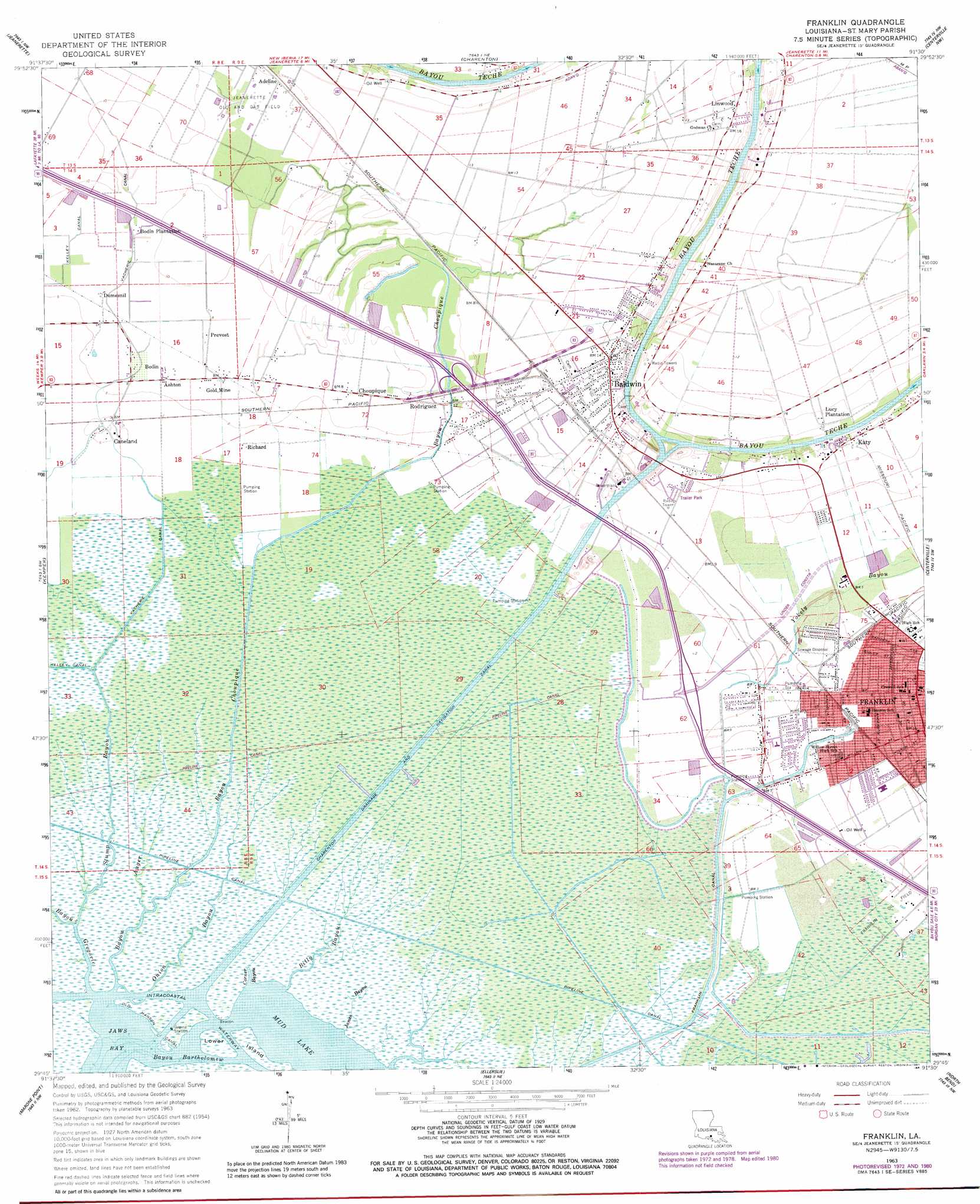
Franklin Topo Map Louisiana
To zoom in, hover over the map of Franklin
USGS Topo Quad 29091g5 - 1:24,000 scale
| Topo Map Name: | Franklin |
| USGS Topo Quad ID: | 29091g5 |
| Print Size: | ca. 21 1/4" wide x 27" high |
| Southeast Coordinates: | 29.75° N latitude / 91.5° W longitude |
| Map Center Coordinates: | 29.8125° N latitude / 91.5625° W longitude |
| U.S. State: | LA |
| Filename: | o29091g5.jpg |
| Download Map JPG Image: | Franklin topo map 1:24,000 scale |
| Map Type: | Topographic |
| Topo Series: | 7.5´ |
| Map Scale: | 1:24,000 |
| Source of Map Images: | United States Geological Survey (USGS) |
| Alternate Map Versions: |
Franklin LA 1963, updated 1964 Download PDF Buy paper map Franklin LA 1963, updated 1978 Download PDF Buy paper map Franklin LA 1963, updated 1981 Download PDF Buy paper map Franklin LA 1994, updated 1998 Download PDF Buy paper map Franklin LA 2012 Download PDF Buy paper map Franklin LA 2015 Download PDF Buy paper map |
1:24,000 Topo Quads surrounding Franklin
New Iberia North |
Loreauville |
Jackass Bay |
Lake Chicot |
Pigeon |
New Iberia South |
Jeanerette |
Charenton |
Centerville Nw |
Centerville Ne |
Weeks |
Kemper |
Franklin |
Centerville |
Tiger Island |
Hammock Lake |
Marone Point |
Ellerslie |
North Bend |
Patterson |
Bayou Blanc |
Lake Point |
Point Chevreuil |
Belle Isle |
Lake Salve |
> Back to 29091e1 at 1:100,000 scale
> Back to 29090a1 at 1:250,000 scale
> Back to U.S. Topo Maps home
Franklin topo map: Gazetteer
Franklin: Bays
Jaws Bay elevation 0m 0′Franklin: Bends
Irish Bend elevation 3m 9′Franklin: Canals
Charenton Drainage and Navigation Canal elevation 0m 0′Franklin Canal elevation 0m 0′
Old Hanson Canal elevation 1m 3′
Vacherie Canal elevation 1m 3′
Franklin: Guts
Bayou Bartholomew elevation 0m 0′Corner Bayou elevation 0m 0′
Franklin: Islands
Lower Island elevation 1m 3′Franklin: Lakes
Mud Lake elevation 1m 3′Franklin: Oilfields
Baldwin Gas Field elevation 2m 6′Jeanerette Oil and Gas Field elevation 2m 6′
Onion Bayou Gas Field elevation 1m 3′
Franklin: Parks
Broussard-Harris Park elevation 2m 6′Caffery Park elevation 2m 6′
Franklin Historic District elevation 4m 13′
Parc Sur La Teche elevation 4m 13′
Franklin: Populated Places
Adeline elevation 3m 9′Ashton elevation 2m 6′
Baldwin elevation 5m 16′
Bodin elevation 2m 6′
Caneland elevation 1m 3′
Choupique elevation 3m 9′
Dumesnil elevation 2m 6′
Franklin elevation 3m 9′
Gold Mine elevation 2m 6′
Katy elevation 4m 13′
Linwood elevation 4m 13′
Prevost elevation 2m 6′
Richard elevation 1m 3′
Rodriquez elevation 2m 6′
Franklin: Post Offices
Baldwin Post Office elevation 5m 16′Franklin Post Office elevation 4m 13′
Franklin: Streams
Bayou Auger elevation 9m 29′Bayou Choupique elevation 1m 3′
Bayou Gregorie elevation 7m 22′
Billy Bayou elevation 3m 9′
James Bayou elevation 0m 0′
Onion Bayou elevation 0m 0′
Stump Bayou elevation 0m 0′
Yokely Bayou elevation -1m -4′
Franklin digital topo map on disk
Buy this Franklin topo map showing relief, roads, GPS coordinates and other geographical features, as a high-resolution digital map file on DVD: