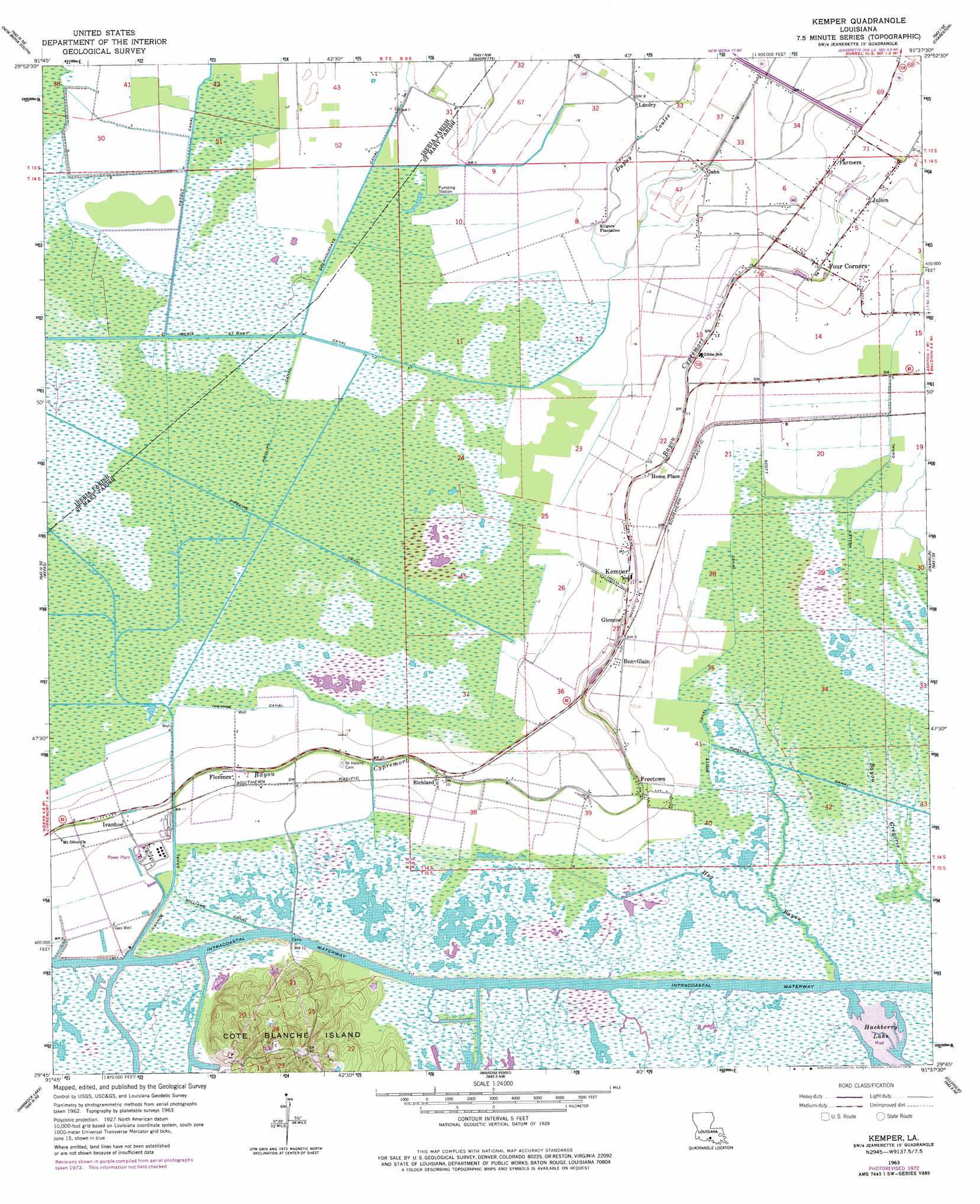
Kemper Topo Map Louisiana
To zoom in, hover over the map of Kemper
USGS Topo Quad 29091g6 - 1:24,000 scale
| Topo Map Name: | Kemper |
| USGS Topo Quad ID: | 29091g6 |
| Print Size: | ca. 21 1/4" wide x 27" high |
| Southeast Coordinates: | 29.75° N latitude / 91.625° W longitude |
| Map Center Coordinates: | 29.8125° N latitude / 91.6875° W longitude |
| U.S. State: | LA |
| Filename: | o29091g6.jpg |
| Download Map JPG Image: | Kemper topo map 1:24,000 scale |
| Map Type: | Topographic |
| Topo Series: | 7.5´ |
| Map Scale: | 1:24,000 |
| Source of Map Images: | United States Geological Survey (USGS) |
| Alternate Map Versions: |
Kemper LA 1963, updated 1964 Download PDF Buy paper map Kemper LA 1963, updated 1978 Download PDF Buy paper map Kemper LA 1994, updated 1998 Download PDF Buy paper map Kemper LA 2012 Download PDF Buy paper map Kemper LA 2015 Download PDF Buy paper map |
1:24,000 Topo Quads surrounding Kemper
Youngsville |
New Iberia North |
Loreauville |
Jackass Bay |
Lake Chicot |
Delcambre |
New Iberia South |
Jeanerette |
Charenton |
Centerville Nw |
Tigre Lagoon |
Weeks |
Kemper |
Franklin |
Centerville |
Cypremort Point |
Hammock Lake |
Marone Point |
Ellerslie |
North Bend |
Bayou Lucien |
Bayou Blanc |
Lake Point |
Point Chevreuil |
Belle Isle |
> Back to 29091e1 at 1:100,000 scale
> Back to 29090a1 at 1:250,000 scale
> Back to U.S. Topo Maps home
Kemper topo map: Gazetteer
Kemper: Canals
Iberia-Saint Mary Canal elevation 2m 6′Ivanhoe Canal elevation 0m 0′
Ivanhoe Canal elevation 0m 0′
Kelley Canal elevation 3m 9′
Patout Canal elevation 1m 3′
Phillips Canal elevation 0m 0′
Scott Canal elevation 1m 3′
Scott Canal elevation 1m 3′
Williams Canal elevation 1m 3′
Kemper: Islands
Cote Blanche Island elevation 21m 68′Kemper: Lakes
Hackberry Lake elevation 0m 0′Kemper: Populated Places
Bonvillain elevation 2m 6′Farmers elevation 3m 9′
Florence elevation 1m 3′
Four Corners elevation 4m 13′
Freetown elevation 2m 6′
Gahn elevation 1m 3′
Glencoe elevation 2m 6′
Home Place elevation 3m 9′
Ivanhoe elevation 2m 6′
Julien elevation 3m 9′
Kemper elevation 4m 13′
Kilgore Plantation elevation 1m 3′
Landry elevation 2m 6′
Richland elevation 2m 6′
United elevation 2m 6′
Kemper: Streams
Dupuy Coulee elevation 1m 3′Hog Bayou elevation 7m 22′
Kemper digital topo map on disk
Buy this Kemper topo map showing relief, roads, GPS coordinates and other geographical features, as a high-resolution digital map file on DVD: