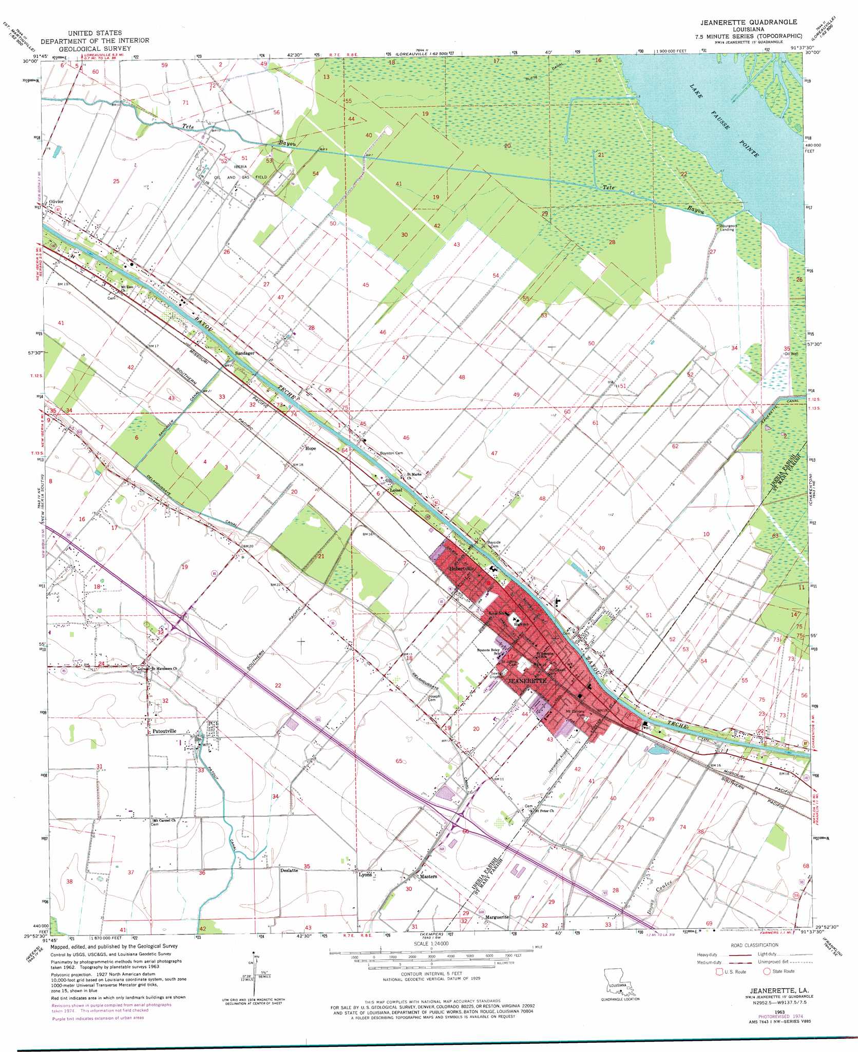
Jeanerette Topo Map Louisiana
To zoom in, hover over the map of Jeanerette
USGS Topo Quad 29091h6 - 1:24,000 scale
| Topo Map Name: | Jeanerette |
| USGS Topo Quad ID: | 29091h6 |
| Print Size: | ca. 21 1/4" wide x 27" high |
| Southeast Coordinates: | 29.875° N latitude / 91.625° W longitude |
| Map Center Coordinates: | 29.9375° N latitude / 91.6875° W longitude |
| U.S. State: | LA |
| Filename: | o29091h6.jpg |
| Download Map JPG Image: | Jeanerette topo map 1:24,000 scale |
| Map Type: | Topographic |
| Topo Series: | 7.5´ |
| Map Scale: | 1:24,000 |
| Source of Map Images: | United States Geological Survey (USGS) |
| Alternate Map Versions: |
Jeanerette LA 1963, updated 1964 Download PDF Buy paper map Jeanerette LA 1963, updated 1978 Download PDF Buy paper map Jeanerette LA 1994, updated 1998 Download PDF Buy paper map Jeanerette LA 2012 Download PDF Buy paper map Jeanerette LA 2015 Download PDF Buy paper map |
1:24,000 Topo Quads surrounding Jeanerette
Broussard |
Parks |
Catahoula |
Lake Mongoulois |
Grand River |
Youngsville |
New Iberia North |
Loreauville |
Jackass Bay |
Lake Chicot |
Delcambre |
New Iberia South |
Jeanerette |
Charenton |
Centerville Nw |
Tigre Lagoon |
Weeks |
Kemper |
Franklin |
Centerville |
Cypremort Point |
Hammock Lake |
Marone Point |
Ellerslie |
North Bend |
> Back to 29091e1 at 1:100,000 scale
> Back to 29090a1 at 1:250,000 scale
> Back to U.S. Topo Maps home
Jeanerette topo map: Gazetteer
Jeanerette: Airports
Diamond Shamrock Heliport elevation 3m 9′Le Maire Memorial Airport elevation 4m 13′
Jeanerette: Canals
Butte Canal elevation 1m 3′Delahoussaye Canal elevation 1m 3′
Jeanerette Canal elevation 0m 0′
Sandager Canal elevation 2m 6′
Jeanerette: Oilfields
Iberia Oil and Gas Field elevation 2m 6′Loisel Gas Field elevation 1m 3′
North Loisel Gas Field elevation 0m 0′
Jeanerette: Parks
Jeanerette City Park elevation 4m 13′Jeanerette: Populated Places
Bourgeois Landing elevation 0m 0′Deslatte elevation 2m 6′
Hope elevation 5m 16′
Hubertville elevation 5m 16′
Jeanerette elevation 5m 16′
Lifenite elevation 6m 19′
Loisel elevation 6m 19′
Lyons elevation 3m 9′
Marguerite elevation 2m 6′
Masters elevation 0m 0′
Patoutville elevation 2m 6′
Sandager elevation 6m 19′
Jeanerette: Post Offices
Jeanerette Post Office elevation 5m 16′Jeanerette: Streams
Tete Bayou elevation 0m 0′Jeanerette digital topo map on disk
Buy this Jeanerette topo map showing relief, roads, GPS coordinates and other geographical features, as a high-resolution digital map file on DVD: