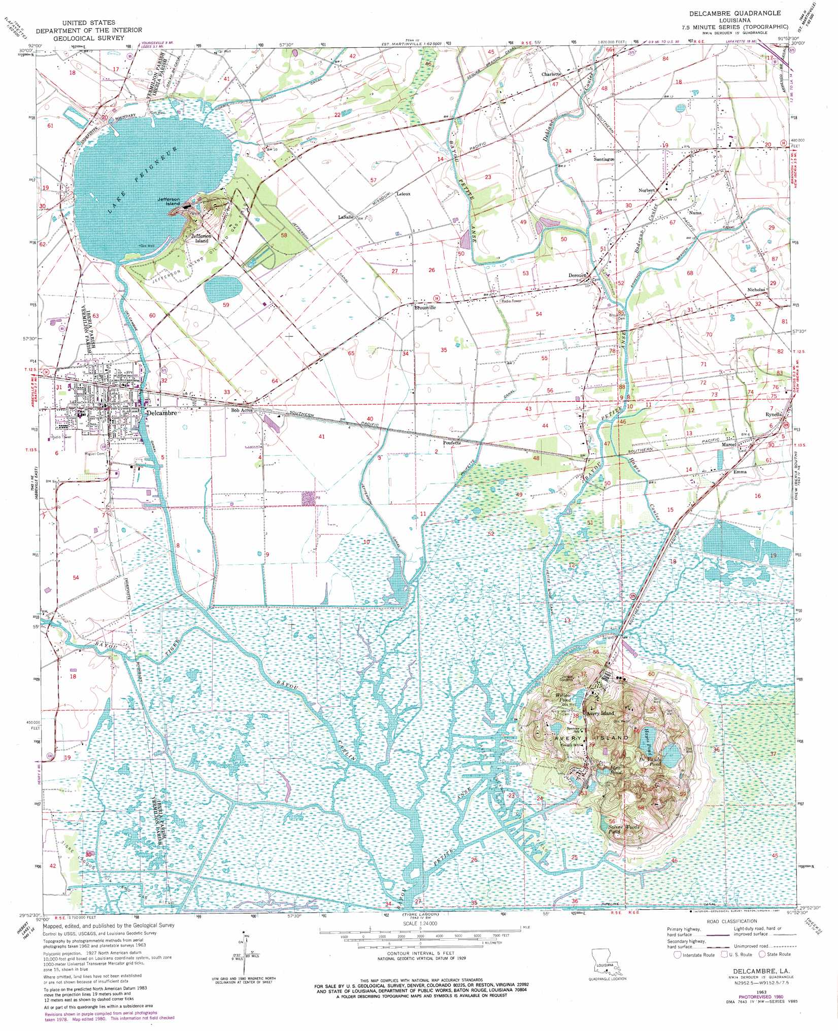
Delcambre Topo Map Louisiana
To zoom in, hover over the map of Delcambre
USGS Topo Quad 29091h8 - 1:24,000 scale
| Topo Map Name: | Delcambre |
| USGS Topo Quad ID: | 29091h8 |
| Print Size: | ca. 21 1/4" wide x 27" high |
| Southeast Coordinates: | 29.875° N latitude / 91.875° W longitude |
| Map Center Coordinates: | 29.9375° N latitude / 91.9375° W longitude |
| U.S. State: | LA |
| Filename: | o29091h8.jpg |
| Download Map JPG Image: | Delcambre topo map 1:24,000 scale |
| Map Type: | Topographic |
| Topo Series: | 7.5´ |
| Map Scale: | 1:24,000 |
| Source of Map Images: | United States Geological Survey (USGS) |
| Alternate Map Versions: |
Delcambre LA 1963, updated 1964 Download PDF Buy paper map Delcambre LA 1963, updated 1981 Download PDF Buy paper map Delcambre LA 1994, updated 1998 Download PDF Buy paper map Delcambre LA 2012 Download PDF Buy paper map Delcambre LA 2015 Download PDF Buy paper map |
1:24,000 Topo Quads surrounding Delcambre
Duson |
Lafayette |
Broussard |
Parks |
Catahoula |
Leroy |
Milton |
Youngsville |
New Iberia North |
Loreauville |
Abbeville West |
Abbeville East |
Delcambre |
New Iberia South |
Jeanerette |
Intracoastal City |
Hebert Lake |
Tigre Lagoon |
Weeks |
Kemper |
Fearman Lake |
Redfish Point |
Cypremort Point |
Hammock Lake |
Marone Point |
> Back to 29091e1 at 1:100,000 scale
> Back to 29090a1 at 1:250,000 scale
> Back to U.S. Topo Maps home
Delcambre topo map: Gazetteer
Delcambre: Airports
Leonards Airfield elevation 2m 6′Transco Delcambre Heliport elevation 2m 6′
Delcambre: Canals
Delcambre Canal elevation 0m 0′Jefferson Canal elevation 1m 3′
Malam Branch Canal elevation 3m 9′
Norris Branch Canal elevation 2m 6′
Petite Anse Canal elevation 2m 6′
Poufette Canal elevation 1m 3′
Delcambre: Islands
Avery Island elevation 17m 55′Jefferson Island elevation 6m 19′
Delcambre: Lakes
Blue Pond elevation 4m 13′De Vance Pond elevation 18m 59′
Hayes Pond elevation 19m 62′
Lake Peigneur elevation 1m 3′
Saline Wood Pond elevation 2m 6′
Willow Pond elevation 13m 42′
Delcambre: Oilfields
Avery Island Oil Field elevation 3m 9′Jefferson Island Oil and Gas Field elevation 2m 6′
Tigre Lagoon Oil and Gas Field elevation 1m 3′
Delcambre: Parks
Jungle Gardens elevation 32m 104′Delcambre: Populated Places
Avery Island elevation 13m 42′Bob Acres elevation 2m 6′
Brousville elevation 2m 6′
Charlotte elevation 3m 9′
Delcambre elevation 2m 6′
Derouen elevation 2m 6′
Emma elevation 1m 3′
Jefferson Island elevation 4m 13′
Lasalle elevation 2m 6′
Leleux elevation 2m 6′
Marce elevation 1m 3′
Nicholas elevation 3m 9′
Norbert elevation 3m 9′
Numa elevation 3m 9′
Poufette elevation 1m 3′
Rynella elevation 2m 6′
Santiague elevation 2m 6′
Delcambre: Post Offices
Avery Island Post Office elevation 10m 32′Delcambre: Streams
Badeaux Coulee elevation 1m 3′Bayou Carlin elevation 0m 0′
Bayou Parc Perdu elevation 2m 6′
Bayou Tigre elevation 0m 0′
Coulee Malam elevation 1m 3′
Deblanc Coulee elevation 3m 9′
Hayes Coulee elevation 0m 0′
Delcambre digital topo map on disk
Buy this Delcambre topo map showing relief, roads, GPS coordinates and other geographical features, as a high-resolution digital map file on DVD: