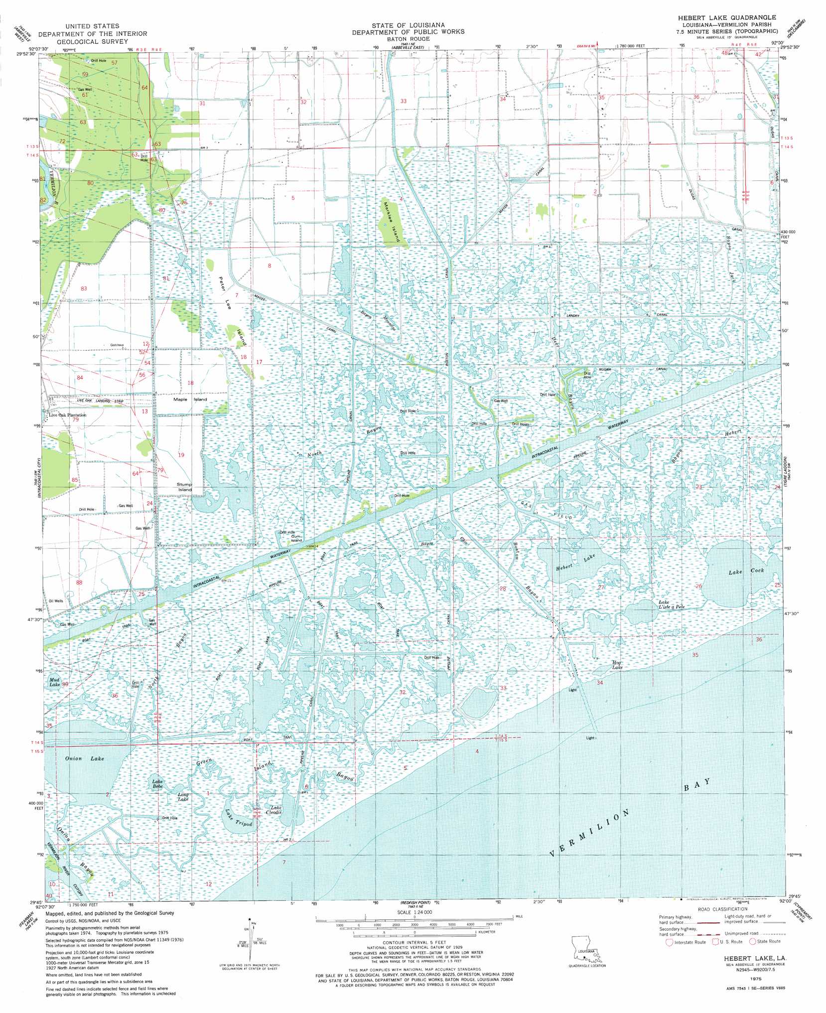
Hebert Lake Topo Map Louisiana
To zoom in, hover over the map of Hebert Lake
USGS Topo Quad 29092g1 - 1:24,000 scale
| Topo Map Name: | Hebert Lake |
| USGS Topo Quad ID: | 29092g1 |
| Print Size: | ca. 21 1/4" wide x 27" high |
| Southeast Coordinates: | 29.75° N latitude / 92° W longitude |
| Map Center Coordinates: | 29.8125° N latitude / 92.0625° W longitude |
| U.S. State: | LA |
| Filename: | o29092g1.jpg |
| Download Map JPG Image: | Hebert Lake topo map 1:24,000 scale |
| Map Type: | Topographic |
| Topo Series: | 7.5´ |
| Map Scale: | 1:24,000 |
| Source of Map Images: | United States Geological Survey (USGS) |
| Alternate Map Versions: |
Hebert Lake LA 2012 Download PDF Buy paper map Hebert Lake LA 2015 Download PDF Buy paper map |
1:24,000 Topo Quads surrounding Hebert Lake
Kaplan North |
Leroy |
Milton |
Youngsville |
New Iberia North |
Kaplan South |
Abbeville West |
Abbeville East |
Delcambre |
New Iberia South |
Forked Island |
Intracoastal City |
Hebert Lake |
Tigre Lagoon |
Weeks |
Pumpkin Islands |
Fearman Lake |
Redfish Point |
Cypremort Point |
Hammock Lake |
Mulberry Island East |
Cheniere Au Tigre |
Hell Hole Bayou |
Bayou Lucien |
Bayou Blanc |
> Back to 29092e1 at 1:100,000 scale
> Back to 29092a1 at 1:250,000 scale
> Back to U.S. Topo Maps home
Hebert Lake topo map: Gazetteer
Hebert Lake: Airports
Live Oak Landing Strip elevation 1m 3′Hebert Lake: Canals
Boston Canal elevation 0m 0′Dugas Canal elevation 1m 3′
Landry Canal elevation 0m 0′
Magee Canal elevation 1m 3′
Mayer Canal elevation 1m 3′
Nugier Canal elevation 1m 3′
Hebert Lake: Islands
Gum Island elevation 1m 3′Maple Island elevation 0m 0′
Marklee Island elevation 0m 0′
Peter Lee Island elevation 0m 0′
Stump Island elevation 1m 3′
Hebert Lake: Lakes
Hebert Lake elevation 0m 0′Hog Lake elevation 1m 3′
Lake Bebe elevation 0m 0′
Lake Cleodis elevation 0m 0′
Lake Cock elevation 0m 0′
Lake L'isle a Pete elevation 3m 9′
Lake Tripod elevation -4m -14′
Long Lake elevation 0m 0′
Mud Lake elevation 5m 16′
Onion Lake elevation -2m -7′
Hebert Lake: Oilfields
Boston Bayou Oil and Gas Field elevation 1m 3′South Erath Gas Field elevation 1m 3′
Hebert Lake: Streams
Bayou Chin elevation 1m 3′Bayou Hebert elevation 0m 0′
Bayou Jack elevation 1m 3′
Bayou Mountine elevation 0m 0′
Boston Bayou elevation 0m 0′
Deer Bayou elevation 0m 0′
Green Island Bayou elevation 0m 0′
North Bayou elevation 0m 0′
Onion Bayou elevation 0m 0′
Hebert Lake digital topo map on disk
Buy this Hebert Lake topo map showing relief, roads, GPS coordinates and other geographical features, as a high-resolution digital map file on DVD: