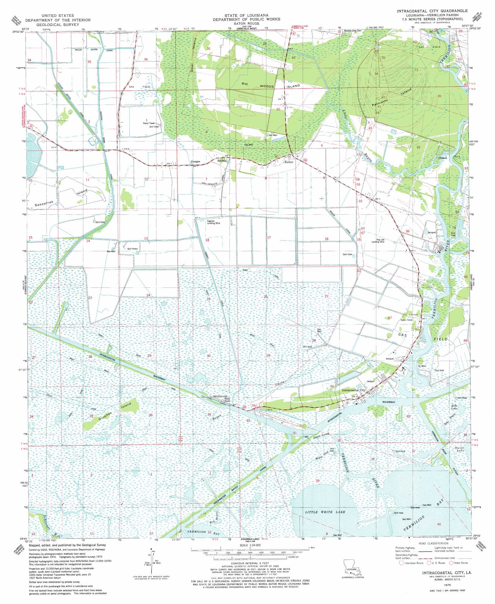
Intracoastal City Topo Map Louisiana
To zoom in, hover over the map of Intracoastal City
USGS Topo Quad 29092g2 - 1:24,000 scale
| Topo Map Name: | Intracoastal City |
| USGS Topo Quad ID: | 29092g2 |
| Print Size: | ca. 21 1/4" wide x 27" high |
| Southeast Coordinates: | 29.75° N latitude / 92.125° W longitude |
| Map Center Coordinates: | 29.8125° N latitude / 92.1875° W longitude |
| U.S. State: | LA |
| Filename: | o29092g2.jpg |
| Download Map JPG Image: | Intracoastal City topo map 1:24,000 scale |
| Map Type: | Topographic |
| Topo Series: | 7.5´ |
| Map Scale: | 1:24,000 |
| Source of Map Images: | United States Geological Survey (USGS) |
| Alternate Map Versions: |
Intracoastal City LA 1975, updated 1978 Download PDF Buy paper map Intracoastal City LA 2012 Download PDF Buy paper map Intracoastal City LA 2015 Download PDF Buy paper map |
1:24,000 Topo Quads surrounding Intracoastal City
Wright |
Kaplan North |
Leroy |
Milton |
Youngsville |
Forked Island Nw |
Kaplan South |
Abbeville West |
Abbeville East |
Delcambre |
Jacks Point Island |
Forked Island |
Intracoastal City |
Hebert Lake |
Tigre Lagoon |
Pecan Island |
Pumpkin Islands |
Fearman Lake |
Redfish Point |
Cypremort Point |
Mulberry Island West |
Mulberry Island East |
Cheniere Au Tigre |
Hell Hole Bayou |
Bayou Lucien |
> Back to 29092e1 at 1:100,000 scale
> Back to 29092a1 at 1:250,000 scale
> Back to U.S. Topo Maps home
Intracoastal City topo map: Gazetteer
Intracoastal City: Airports
Central Industries Airport elevation 0m 0′Era Heliport elevation 1m 3′
Exxon Intracoastal City Terminal Seaplane Base elevation 1m 3′
Intracoastal City Heliport elevation 1m 3′
Intracoastal City Heliport elevation 1m 3′
Roy Lee Landing Strip elevation 1m 3′
Sagrera Landing Strip elevation 1m 3′
Tenneco Intracoastal Heliport elevation 1m 3′
Union Oil Company of California Heliport elevation 1m 3′
Intracoastal City: Bays
Little White Lake elevation 0m 0′Intracoastal City: Canals
Hall-Schultz Canal elevation 1m 3′Hebert Canal elevation 1m 3′
Meaux Canal elevation 1m 3′
Miller Island Canal elevation 1m 3′
Seventh Ward Canal elevation 0m 0′
Intracoastal City: Channels
Four Mile Cutoff elevation 0m 0′Intracoastal City: Dams
Leland Bowman Lock elevation 0m 0′Intracoastal City: Forests
Big Woods elevation 1m 3′Intracoastal City: Islands
Big Woods Island elevation 1m 3′Goat Island elevation 1m 3′
Grophes Island elevation 0m 0′
Palmetto Island elevation 1m 3′
Sassafras Island elevation 1m 3′
Shell Island elevation 0m 0′
Intracoastal City: Lakes
Bebe Lake elevation 0m 0′Intracoastal City: Oilfields
Esther Gas Field elevation 1m 3′Intracoastal City Gas Field elevation 1m 3′
Live Oak Oil and Gas Field elevation 0m 0′
North Buck Point Gas Field elevation 1m 3′
Southwest Esther Gas Field elevation 1m 3′
Theall Gas Field elevation 1m 3′
Intracoastal City: Populated Places
Esther elevation 1m 3′Intracoastal City elevation 1m 3′
Intracoastal City: Post Offices
Esther Post Office elevation 2m 6′Intracoastal City: Streams
Bayou Chene elevation 0m 0′Bayou Glad elevation 0m 0′
Bayou Sorrow elevation 0m 0′
Bebe Bayou elevation 1m 3′
Hog Bayou elevation 0m 0′
Little Bayou elevation 0m 0′
Vermilion River elevation 0m 0′
Intracoastal City digital topo map on disk
Buy this Intracoastal City topo map showing relief, roads, GPS coordinates and other geographical features, as a high-resolution digital map file on DVD: