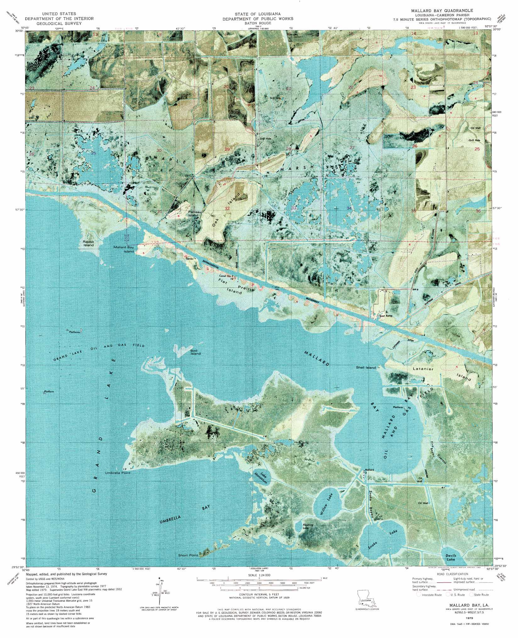
Mallard Bay Topo Map Louisiana
To zoom in, hover over the map of Mallard Bay
USGS Topo Quad 29092h6 - 1:24,000 scale
| Topo Map Name: | Mallard Bay |
| USGS Topo Quad ID: | 29092h6 |
| Print Size: | ca. 21 1/4" wide x 27" high |
| Southeast Coordinates: | 29.875° N latitude / 92.625° W longitude |
| Map Center Coordinates: | 29.9375° N latitude / 92.6875° W longitude |
| U.S. State: | LA |
| Filename: | p29092h6.jpg |
| Download Map JPG Image: | Mallard Bay topo map 1:24,000 scale |
| Map Type: | Orthophoto |
| Topo Series: | 7.5´ |
| Map Scale: | 1:24,000 |
| Source of Map Images: | United States Geological Survey (USGS) |
| Alternate Map Versions: |
Mallard Bay LA 1979, updated 1980 Download PDF Buy paper map Mallard Bay LA 2012 Download PDF Buy paper map Mallard Bay LA 2015 Download PDF Buy paper map |
1:24,000 Topo Quads surrounding Mallard Bay
Lacassine |
Welsh South |
Jennings |
Mermentau |
Crowley West |
Hayes |
Thornwell |
Lake Arthur |
Gueydan |
Wright |
Lake Misere |
Latania Lake |
Mallard Bay |
Latanier Bayou |
Forked Island Nw |
Grand Cheniere |
Catfish Lake |
Collicon Lake |
Lake Le Bleu |
Jacks Point Island |
Hog Bayou |
Cow Island |
Deep Lake |
Floating Turf Bayou |
Pecan Island |
> Back to 29092e1 at 1:100,000 scale
> Back to 29092a1 at 1:250,000 scale
> Back to U.S. Topo Maps home
Mallard Bay topo map: Gazetteer
Mallard Bay: Bays
Mallard Bay elevation 0m 0′Umbrella Bay elevation 0m 0′
Mallard Bay: Canals
Canal Number Two elevation 0m 0′Latanier Ditch elevation 0m 0′
Lulu Canal elevation 2m 6′
Ridge Canal elevation 1m 3′
Mallard Bay: Capes
Short Point elevation 0m 0′Umbrella Point elevation 0m 0′
Mallard Bay: Islands
Bird Island elevation 0m 0′Flat Prairie Island elevation 1m 3′
Latanier Island elevation 1m 3′
Mallard Bay Island elevation 3m 9′
Oak Island elevation 1m 3′
Perreau Island elevation 2m 6′
Rabbit Island elevation 1m 3′
Shell Island elevation 0m 0′
Mallard Bay: Lakes
Devils Lake elevation 0m 0′Floating Lake elevation 0m 0′
Grand Lake elevation 0m 0′
Lake Monzelum elevation 0m 0′
Snake Lake elevation 1m 3′
Willow Lake elevation -2m -7′
Mallard Bay: Oilfields
Grand Lake Oil and Gas Field elevation 0m 0′Mallard Bay Oil and Gas Field elevation 0m 0′
Mallard Bay: Streams
Five Bayou Cypress elevation 0m 0′Mallard Bay: Swamps
Maple Marsh elevation 1m 3′Mallard Bay digital topo map on disk
Buy this Mallard Bay topo map showing relief, roads, GPS coordinates and other geographical features, as a high-resolution digital map file on DVD: