Johnsons Bayou Topo Map Louisiana
To zoom in, hover over the map of Johnsons Bayou
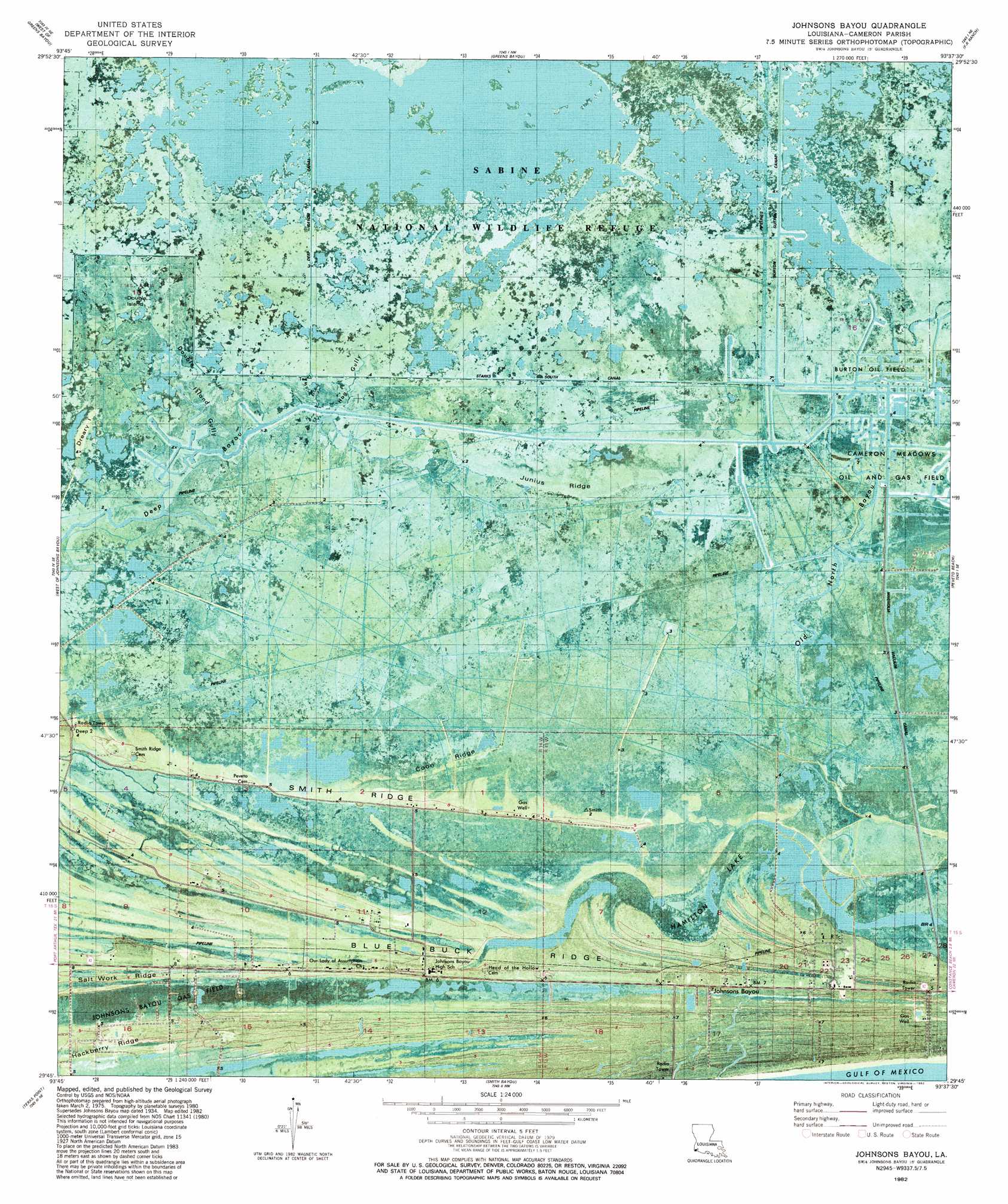
USGS Topo Quad 29093g6 - 1:24,000 scale
| Topo Map Name: | Johnsons Bayou |
| USGS Topo Quad ID: | 29093g6 |
| Print Size: | ca. 21 1/4" wide x 27" high |
| Southeast Coordinates: | 29.75° N latitude / 93.625° W longitude |
| Map Center Coordinates: | 29.8125° N latitude / 93.6875° W longitude |
| U.S. State: | LA |
| Filename: | p29093g6.jpg |
| Download Map JPG Image: | Johnsons Bayou topo map 1:24,000 scale |
| Map Type: | Orthophoto |
| Topo Series: | 7.5´ |
| Map Scale: | 1:24,000 |
| Source of Map Images: | United States Geological Survey (USGS) |
| Alternate Map Versions: |
Johnsons Bayou LA 1934, updated 1955 Download PDF Buy paper map Johnsons Bayou LA 1934, updated 1970 Download PDF Buy paper map Johnsons Bayou LA 1934, updated 1973 Download PDF Buy paper map Johnsons Bayou LA 1975, updated 1976 Download PDF Buy paper map Johnsons Bayou LA 1982, updated 1982 Download PDF Buy paper map Johnson Bayou LA 2012 Download PDF Buy paper map Johnson Bayou LA 2015 Download PDF Buy paper map |
1:24,000 Topo Quads surrounding Johnsons Bayou
Terry |
Orangefield |
Orange |
Cameron Farms |
Black Lake |
Port Arthur North |
West Of Greens Bayou |
Greens Bayou |
Five Lakes |
Browns Lake |
Port Arthur South |
West Of Johnsons Bayou |
Johnsons Bayou |
Peveto Beach |
Holly Beach |
Sabine Pass |
Texas Point |
Smith Bayou |
||
> Back to 29093e1 at 1:100,000 scale
> Back to 29092a1 at 1:250,000 scale
> Back to U.S. Topo Maps home
Johnsons Bayou topo map: Gazetteer
Johnsons Bayou: Airports
Johnsons Bayou Heliport elevation 2m 6′Station 44 Heliport elevation 1m 3′
Johnsons Bayou: Canals
Magnolia Vacuum Canal elevation 0m 0′Starks South Canal elevation 1m 3′
Johnsons Bayou: Islands
Double Island elevation 0m 0′Dreary Island elevation 0m 0′
Johnsons Bayou: Lakes
Hamilton Lake elevation 0m 0′Johnsons Bayou: Oilfields
Burton Oil Field elevation 0m 0′Cameron Meadows Oil and Gas Field elevation 1m 3′
Deep Bayou Oil and Gas Field elevation 1m 3′
Johnsons Bayou Gas Field elevation 1m 3′
Johnsons Bayou: Populated Places
Johnsons Bayou elevation 1m 3′Johnsons Bayou: Post Offices
Johnsons Bayou Post Office elevation 2m 6′Johnsons Bayou: Ridges
Coon Ridge elevation 1m 3′Junius Ridge elevation 1m 3′
Smith Ridge elevation 0m 0′
Johnsons Bayou: Streams
Double Island Gully elevation 0m 0′Hog Gully elevation 0m 0′
Old Bayou elevation 1m 3′
Old North Bayou elevation 0m 0′
Johnsons Bayou digital topo map on disk
Buy this Johnsons Bayou topo map showing relief, roads, GPS coordinates and other geographical features, as a high-resolution digital map file on DVD: