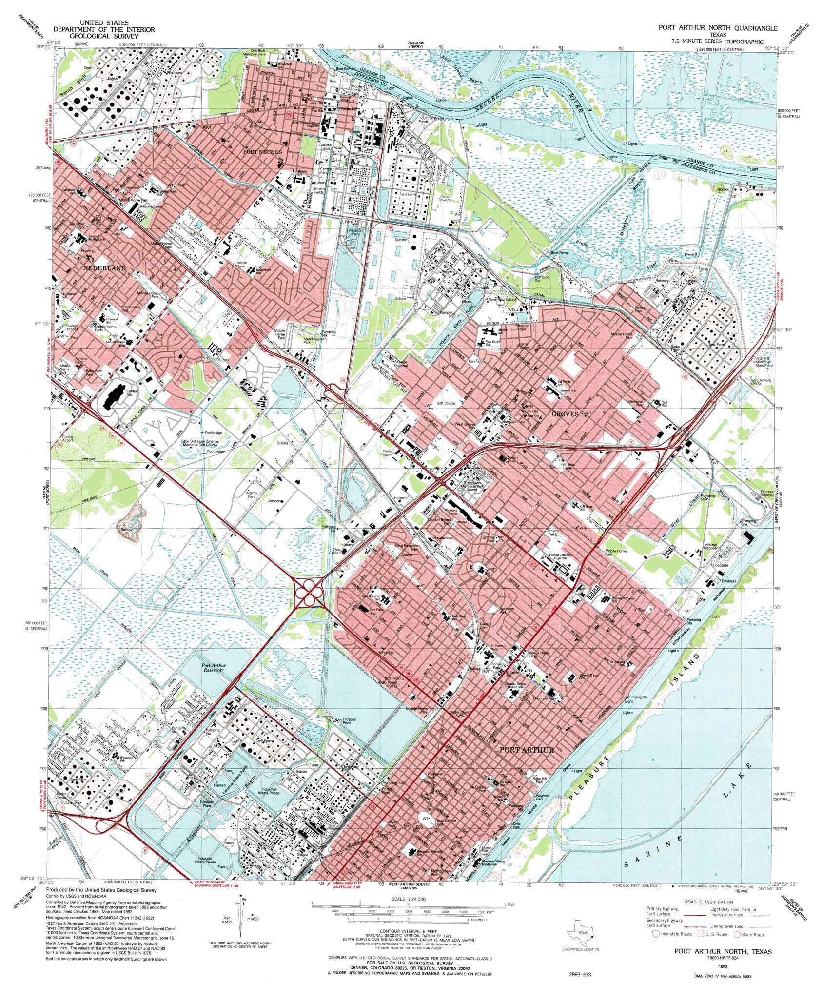
Port Arthur North Topo Map Texas
To zoom in, hover over the map of Port Arthur North
USGS Topo Quad 29093h8 - 1:24,000 scale
| Topo Map Name: | Port Arthur North |
| USGS Topo Quad ID: | 29093h8 |
| Print Size: | ca. 21 1/4" wide x 27" high |
| Southeast Coordinates: | 29.875° N latitude / 93.875° W longitude |
| Map Center Coordinates: | 29.9375° N latitude / 93.9375° W longitude |
| U.S. State: | TX |
| Filename: | o29093h8.jpg |
| Download Map JPG Image: | Port Arthur North topo map 1:24,000 scale |
| Map Type: | Topographic |
| Topo Series: | 7.5´ |
| Map Scale: | 1:24,000 |
| Source of Map Images: | United States Geological Survey (USGS) |
| Alternate Map Versions: |
Port Arthur North TX 1943, updated 1953 Download PDF Buy paper map Port Arthur North TX 1957, updated 1958 Download PDF Buy paper map Port Arthur North TX 1957, updated 1972 Download PDF Buy paper map Port Arthur North TX 1957, updated 1979 Download PDF Buy paper map Port Arthur North TX 1957, updated 1983 Download PDF Buy paper map Port Arthur North TX 1993 Download PDF Buy paper map Port Arthur North TX 2010 Download PDF Buy paper map Port Arthur North TX 2013 Download PDF Buy paper map Port Arthur North TX 2016 Download PDF Buy paper map |
1:24,000 Topo Quads surrounding Port Arthur North
Voth |
Pine Forest |
Texla |
Mauriceville |
Echo |
Beaumont West |
Beaumont East |
Terry |
Orangefield |
Orange |
Fannett East |
Port Acres |
Port Arthur North |
West Of Greens Bayou |
Greens Bayou |
Alligator Hole Marsh |
Big Hill Bayou |
Port Arthur South |
West Of Johnsons Bayou |
Johnsons Bayou |
Star Lake |
Clam Lake |
Sabine Pass |
Texas Point |
Smith Bayou |
> Back to 29093e1 at 1:100,000 scale
> Back to 29092a1 at 1:250,000 scale
> Back to U.S. Topo Maps home
Port Arthur North topo map: Gazetteer
Port Arthur North: Airports
P P H Heliport elevation 1m 3′Patco Heliport elevation 0m 0′
Saint Mary Hospital of Port Arthur Heliport elevation 2m 6′
Texaco Chemical Company-East Heliport elevation 4m 13′
Port Arthur North: Canals
Atlantic Canal elevation 5m 16′Sabine Neches Canal elevation 0m 0′
Port Arthur North: Guts
Left Prong Molasses Bayou elevation 2m 6′Molasses Bayou elevation 2m 6′
Right Prong Molasses Bayou elevation 1m 3′
West Crane Bayou elevation 2m 6′
Port Arthur North: Islands
Pleasure Island elevation 0m 0′Port Arthur North: Parks
Adams Park elevation 1m 3′Aurora Park elevation 2m 6′
Babe Ruth Park elevation 3m 9′
Blue Bonnet Park elevation 2m 6′
Bryan Park elevation 2m 6′
Bulldog Stadium elevation 5m 16′
C Doornbos Park elevation 4m 13′
Carl A Parker Multipurpose Center elevation 2m 6′
Cecil Reynolds Park elevation 2m 6′
Central Park elevation 5m 16′
Civic Park elevation 2m 6′
De Queen Park elevation 2m 6′
Fairlea Park elevation 3m 9′
Gates Park elevation 3m 9′
Greenlawn Memorial Park elevation 2m 6′
Griffing Park elevation 3m 9′
Groves City Park elevation 3m 9′
Hermann Park elevation 2m 6′
Hoffpuair Field elevation 3m 9′
Hughen Park elevation 2m 6′
Lions Park elevation 2m 6′
London Bridge Park elevation 1m 3′
Meadowgreen Park elevation 1m 3′
Memorial Park elevation 2m 6′
Memorial Stadium elevation 2m 6′
Montgomery Park elevation 2m 6′
Pioneer Park elevation 2m 6′
Port Neches - Grove High School Football and Track Stadium elevation 5m 16′
Port Neches Park elevation 5m 16′
Roosevelt Park elevation 2m 6′
Roosevelt Park elevation 2m 6′
Rose Hill Park elevation 2m 6′
Sunset Park elevation 5m 16′
Tex Ritter Park elevation 5m 16′
West Groves Park elevation 3m 9′
Port Arthur North: Pillars
Veterans Memorial Monument elevation 2m 6′Port Arthur North: Populated Places
Atreco elevation 2m 6′Griffing Park elevation 3m 9′
Groves elevation 4m 13′
Lakeview elevation 2m 6′
Nederland elevation 5m 16′
Pear Ridge elevation 2m 6′
Port Arthur elevation 2m 6′
Port Neches elevation 5m 16′
Port Arthur North: Reservoirs
Port Arthur Reservoir elevation 3m 9′Port Arthur North: Streams
Bird Island Bayou elevation 0m 0′Nig Bayou elevation 0m 0′
Port Arthur North digital topo map on disk
Buy this Port Arthur North topo map showing relief, roads, GPS coordinates and other geographical features, as a high-resolution digital map file on DVD: