Texas City Topo Map Texas
To zoom in, hover over the map of Texas City
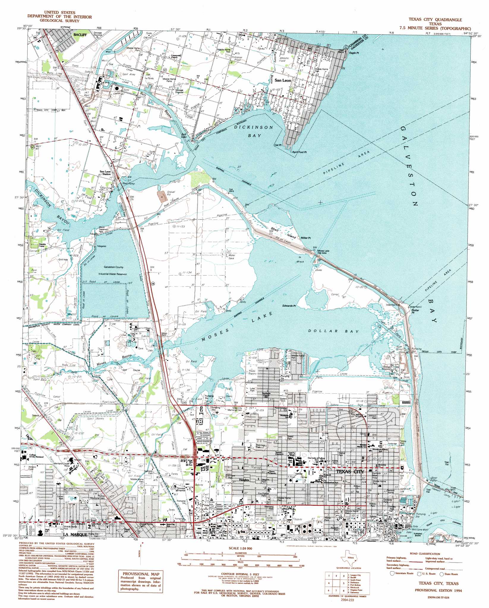
USGS Topo Quad 29094d8 - 1:24,000 scale
| Topo Map Name: | Texas City |
| USGS Topo Quad ID: | 29094d8 |
| Print Size: | ca. 21 1/4" wide x 27" high |
| Southeast Coordinates: | 29.375° N latitude / 94.875° W longitude |
| Map Center Coordinates: | 29.4375° N latitude / 94.9375° W longitude |
| U.S. State: | TX |
| Filename: | o29094d8.jpg |
| Download Map JPG Image: | Texas City topo map 1:24,000 scale |
| Map Type: | Topographic |
| Topo Series: | 7.5´ |
| Map Scale: | 1:24,000 |
| Source of Map Images: | United States Geological Survey (USGS) |
| Alternate Map Versions: |
Texas City TX 1929 Download PDF Buy paper map Texas City TX 1943, updated 1952 Download PDF Buy paper map Texas City TX 1954, updated 1958 Download PDF Buy paper map Texas City TX 1954, updated 1970 Download PDF Buy paper map Texas City TX 1954, updated 1977 Download PDF Buy paper map Texas City TX 1994, updated 1994 Download PDF Buy paper map Texas City TX 2010 Download PDF Buy paper map Texas City TX 2013 Download PDF Buy paper map Texas City TX 2016 Download PDF Buy paper map |
1:24,000 Topo Quads surrounding Texas City
Pasadena |
La Porte |
Morgan Point |
Umbrella Point |
Oak Island |
Friendswood |
League City |
Bacliff |
Smith Point |
Lake Stephenson |
Algoa |
Dickinson |
Texas City |
Port Bolivar |
Flake |
Mustang Bayou |
Hitchcock |
Virginia Point |
Galveston |
The Jetties |
Hoskins Mound |
Sea Isle |
Lake Como |
> Back to 29094a1 at 1:100,000 scale
> Back to 29094a1 at 1:250,000 scale
> Back to U.S. Topo Maps home
Texas City topo map: Gazetteer
Texas City: Airports
Austinia Airport elevation 4m 13′B and S Ultralight Airport elevation 4m 13′
Mainland Regional Health Care System Heliport elevation 5m 16′
Texas City: Bays
Dickinson Bay elevation 0m 0′Dollar Bay elevation 0m 0′
Salt Bayou elevation 0m 0′
Texas City: Capes
April Fool Point elevation 0m 0′Cat Point elevation 2m 6′
Dollar Point elevation 0m 0′
Eagle Point elevation 0m 0′
Edwards Point elevation 1m 3′
Miller Point elevation 0m 0′
Texas City: Dams
Galveston County Water Reservoir Dam elevation 3m 9′Moses Lake Tide Gate elevation 0m 0′
Texas City: Guts
Silo Bayou elevation 0m 0′Texas City: Islands
Shell Island elevation 1m 3′Texas City: Lakes
Moses Lake elevation 0m 0′Salt Lake elevation 0m 0′
Texas City: Parks
Bayou Park elevation 5m 16′Braslau Park elevation 3m 9′
Bremond Park elevation 4m 13′
Carver Park elevation 5m 16′
Clairmont Park elevation 3m 9′
DeLeon Park elevation 3m 9′
Eastside Park elevation 3m 9′
Fire Fighter Park elevation 4m 13′
Galveston County Water Reservoir Park elevation 2m 6′
Goddard Park elevation 2m 6′
Goodson Park elevation 2m 6′
Heights Park elevation 4m 13′
Insley Park elevation 2m 6′
Johnson Park elevation 2m 6′
Kohfeldt Park elevation 3m 9′
Kohfeldt Park elevation 4m 13′
La Salle Park elevation 2m 6′
Lulac Park elevation 2m 6′
Noble Park elevation 3m 9′
Nuckols Park elevation 3m 9′
Robinson Park elevation 3m 9′
Sanders Park elevation 3m 9′
Steed Park elevation 3m 9′
Stingaree Stadium elevation 2m 6′
Tarpey Park elevation 2m 6′
Trahan Park elevation 3m 9′
Walker Park elevation 2m 6′
Texas City: Populated Places
Heights elevation 4m 13′Nadeau elevation 3m 9′
San Leon elevation 3m 9′
Texas City elevation 3m 9′
Texas City: Reservoirs
Galveston County Industrial Water Reservoir elevation 3m 9′Galveston County Water Reservoir elevation 3m 9′
Texas City: Streams
Dickinson Bayou elevation 0m 0′Factory Bayou elevation 0m 0′
Moses Bayou elevation 0m 0′
Windmill Bayou elevation 0m 0′
Texas City digital topo map on disk
Buy this Texas City topo map showing relief, roads, GPS coordinates and other geographical features, as a high-resolution digital map file on DVD: